
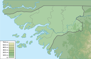
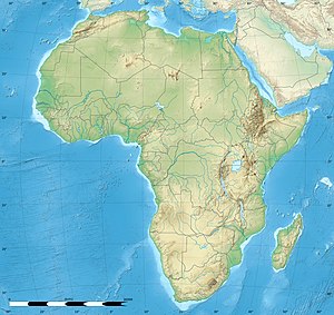
Guinea-Bissau, officially the Republic of Guinea-Bissau, is a country in West Africa that covers 36,125 square kilometres (13,948 sq mi) with an estimated population of 2,026,778. It borders Senegal to its north and Guinea to its southeast.
The region now known as Guinea-Bissau, in West Africa, has been inhabited by humans for thousands of years. During the 13th century CE, it was a province of the Mali Empire which later became independent as the empire of Kaabu. The Portuguese Empire claimed the region during the 1450s, but its control was limited to several forts along the coast during most of this period; it gained control of the mainland after a series of "pacification campaigns" from 1912 to 1915, which used military forces to violently crush local resistance. The offshore Bijagos Islands were not colonized until 1936. Guinea-Bissau gained independence from Portugal in 1974. The introduction of multi-party politics in 1991 led to the first multi-party elections in 1994. A civil war broke out in 1998, which lasted until the following year.

Bissau is the capital and largest city of Guinea-Bissau. As of 2015, it had a population of 492,004. Bissau is located on the Geba River estuary, off the Atlantic Ocean, and is Guinea-Bissau's largest city, major port, its administrative and military center.
The music of Guinea-Bissau is most widely associated with the polyrhythmic genre of gumbe, the country's primary musical export. Tina and tinga are other popular genres.

Portuguese Guinea, called the Overseas Province of Guinea from 1951 until 1972 and then State of Guinea from 1972 until 1974, was a Portuguese overseas province in West Africa from 1588 until 10 September 1974, when it gained independence as Guinea-Bissau.
Articles related to Guinea-Bissau include:

Buba is the largest city in southern Guinea-Bissau and the capital of the Quinara region. Itlies on the extreme end of the Rio Grande de Buba, near the Contanhez National Park, and has a population 6,815.

Bolama is the main town of Bolama Island and the capital of the Bolama Region. Though once the capital of Portuguese Guinea, it has a population of just 4,819 and much of its colonial era architecture is in a state of severe decay. The town is almost surrounded by mangrove swamps and is now mostly known for its production of cashew nuts.

Farim is a town of northern Guinea-Bissau. It sits on the north bank of the Farim/Cacheu River, about 215 km up the river from Cacheu. Population 8,661.

Quinara is a region in central Guinea-Bissau and its capital is Fulacunda. There has not been any local administration since the civil war of 1998-99 and all the social services are done by organs of civil society and other government agencies. It is a coastal region covered with Mangrove swamps, rain forest and tangled forest and receives an annual rainfall of more than 1,000 mm (39 in).

There are 39 sectors of Guinea-Bissau which subdivide the regions. The sectors are further subdivided into smaller groups called sections ; which are further subdivided into populated places. Here are the following listed below, by region:
Clube de Futebol Os Balantas is a Guinea-Bissauan football club based in Mansôa. They play in the top division in Guinean football, the Campeonato Nacional da Guiné-Bissau. The club is named after the Balanta people, the club location where the people inhabit. Mansoa is the main city of the Balantas in Guinea-Bissau. It is being the most popular club of the Oio Region.
The Balanta are an ethnic group found in Guinea-Bissau, Guinea, Senegal, Cape Verde and The Gambia. They are the second largest ethnic group of Guinea-Bissau, representing around a quarter of the population. Despite their numbers, they have remained outside the colonial and postcolonial state because of their social organisation. The Balanta can be divided into six dialects: Nyacra, Ganja (Mane), Naga, Patch, Sofar and Kentohe. The largest of which are the Balanta Kentohe.

The official language of Guinea-Bissau is Portuguese, which was spoken by 32.1% of the population according to the 2009 census. It is the language of instruction in schools, the language of literary production, the written press, legislation and administration.
Papels, also known as Moium, Oium, Papei, Pepel or Pelels, are an ethnic group primarily located in Guinea-Bissau, though are also found in Casamance (Senegal) and Guinea. Their population in Guinea-Bissau is about 183,000, with 9,000 living outside of the country. They traditionally engaged in hunting and agriculture.
Bissau-Guinean Americans are Americans of Bissau-Guinean descent. As was the case with almost all current West African coastal countries, the first people in the United States from present-day Guinea-Bissau were imported as slaves. Thus, in the 21st century, there are many African Americans who have discovered, through DNA analysis, they descend mainly or at least partly, from Bissau-Guinean enslaved people.

Bolama is the closest of the Bissagos Islands to the mainland of Guinea-Bissau. The island has a population of 6,024. It shares its name with its largest settlement, the town Bolama, which is the capital of the island and the Bolama Region. A causeway links the island to the Ilha das Cobras. Attractions on the island include sandy beaches and the abandoned ruins of the town of Bolama. It is known for its cashew nuts.
Teodora Inácia Gomes is a politician, feminist and women's rights activist, who is a former fighter in the struggle for Independence of Guinea-Bissau from Portuguese rule, and is Deputy Leader of African Party for the Independence of Guinea and Cape Verde (PAIGC).
Patrícia Godinho Gomes is a Bissau-Guinean historian and academic whose research studies the role of women in anticolonial resistance, African feminisms and gender in Lusophone countries with a particular focus on Guinea-Bissau and Cape Verde.

British Guinea or Colony of Bolama and Bolama River, was a colony of the United Kingdom in West Africa. Its capital was in the city of Bolama.
 Source Fonte Frondosa, Empada, since 1946
 Buba river near Empada, 2018
