East Godavari district or Toorpu Godavari Jilla is a district in Coastal Andhra region of Andhra Pradesh, India. Its district headquarters is at Kakinada. As of Census 2011, it became the most populous district of the state with a population of 5,151,549. Rajahmundry and Kakinada are the two largest cities in the Godavari districts in terms of population.

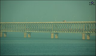
Rajahmundry, officially known as Rajamahendravaram, is a city located in East Godavari district in the Indian state of Andhra Pradesh. The city is located on the banks of Godavari River. It is a Municipal corporation and also the headquarters of both Rajahmundry Rural and Rajahmundry Urban mandals. It is administered under Rajahmundry revenue division. As per 2018 Census, it is the fourth most populous city in the state, with a population of 7,23,569. The city is known for its Historical, Cultural, Agricultural and Economic backgrounds and hence, it is known as the Cultural Capital of Andhra Pradesh. The Road cum Rail bridge across Godavari River which is one of the longest of it's kind, connects the city with the town of Kovvur. Rajamahendravaram is one of the famous and largest city after Visakhapatnam and Vijayawada.

Kovvur is a town in West Godavari district of the Indian state of Andhra Pradesh. It is a municipality and the mandal headquarters of Kovvur mandal in Kovvur revenue division.

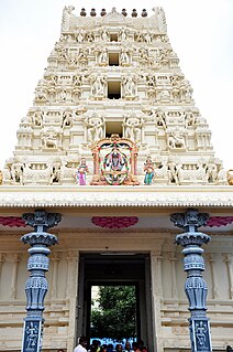
Dwaraka Tirumala is a census town in West Godavari district of the Indian state of Andhra Pradesh. It is located in Dwaraka Tirumala mandal of Eluru revenue division. The Venkateswara Temple is a pilgrimage center for hindus, which is the abode of Lord Venkateswara. This is often referred by the locals as Chinna Tirupati, meaning mini Tirupati.

Palakollu is the administrative headquarters of Palakollu Mandal in Narasapuram revenue division in West Godavari district of the Indian state of Andhra Pradesh. Palakollu is situated in Coastal Andhra region of the state. Occupying 19.49 square kilometres (7.53 sq mi) As of 2011 census, it has a population of about 61.2 kilo and a Metro population of about 81.1 kilo, making it the fourth most populous city in West Godavari District in Andhra pradesh. Palakollu City was selected for the year 2015-16 Housing for All Under Pradhan Mantri Awas Yojana for house less poor in the urban areas. At an average altitude of 1.5 metres (4.9 ft), Palakollu city is situated on National Highway 165 (India) and National Highway 216 (India) It is bounded by Krishna district on the west, East Godavari district on the east, Bay of Bengal on the south and the state of Telangana on the north. which is home to Ksheerarama, one of the five great Pancharama Kshetras.

Narasapuram, is a town in West Godavari district of the Indian state of Andhra Pradesh. It is a municipality and mandal headquarters of Narasapuram mandal in Narasapuram revenue division. The town is situated on the banks of the Vasista Godavari River. The city exports Lace as the lace industry is more prevalent in the city and its surroundings.

Eluru mandal is one of the 46 mandals in West Godavari district of the Indian state of Andhra Pradesh. It is administered under Eluru revenue division and its headquarters are located at Eluru city. The mandal is bounded by Pedapadu mandal, Pedavegi mandal, Denduluru mandal, Bhimadole mandal and it also borders Krishna district.

Tangellamudi is a census town in West Godavari district of the Indian state of Andhra Pradesh. It is located in Eluru mandal of Eluru revenue division. The town is a constituent of Eluru urban agglomeration.

Satrampadu is a census town in West Godavari district of the Indian state of Andhra Pradesh. It is located in Eluru mandal of Eluru revenue division. The town is a constituent of Eluru urban agglomeration.

Pedavegi mandal is one of the 46 mandals in West Godavari district of the Indian state of Andhra Pradesh. It is administered under Eluru revenue division and its headquarters are located at Pedavegi. The mandal is bounded by Eluru mandal, Denduluru mandal, Kamavarapukota mandal.

Tadepalligudem mandal is one of the 48 mandals in West Godavari district of the Indian state of Andhra Pradesh. It is under the administration of Eluru revenue division and the headquarters are located at Tadepalligudem. The mandal is bounded by Nallajerla, Devarapalle, Nidadavolu, Unguturu, Pentapadu, Tanuku and Undrajavaram mandals.

Tanuku mandal is one of the 48 mandals in West Godavari district of the Indian state of Andhra Pradesh. It is under the administration of Kovvur revenue division and the headquarters are located at Tanuku. The mandal is bounded by Nallajerla, Devarapalle, Nidadavolu, Unguturu, Pentapadu, Tanuku and Undrajavaram mandals.

Eluru Rural is a partial out growth of Eluru in West Godavari district of the Indian state of Andhra Pradesh. It is located in Eluru mandal of Eluru revenue division. It is also a constituent of Eluru urban agglomeration.

Dwaraka Tirumala mandal is one of the 48 mandals in West Godavari district of the Indian state of Andhra Pradesh. It is under the administration of Eluru revenue division and the headquarters are located at Dwaraka Tirumala. The mandal is bounded by Jangareddygudem, Koyyalagudem, Kamavarapukota, Nallajerla, Pedavegi, Unguturu, Denduluru and Bhimadole mandals.
Jangareddygudem is a mandal in West Godavari district in the state of Andhra Pradesh in India.

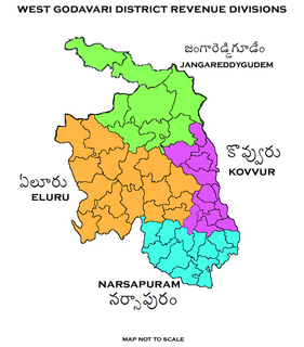
Jangareddygudem revenue division is an administrative division in the West Godavari district of the Indian state of Andhra Pradesh. It is one of the 4 revenue divisions in the district which consists of 8 mandals under its administration. Jangareddygudem is the divisional headquarters.

Komadavole is a out growth of Eluru city in West Godavari district of the Indian state of Andhra Pradesh. It is located in Eluru mandal of Eluru revenue division. It is also a constituent of Eluru Urban Agglomeration.

Madepalle is a village in West Godavari district of the Indian state of Andhra Pradesh. It is located in Eluru mandal of Eluru revenue division. The town is a constituent of Eluru urban agglomeration.

Malkapuram is a village in West Godavari district of the Indian state of Andhra Pradesh. It is located in Eluru mandal of Eluru revenue division. The town is a constituent of Eluru urban agglomeration.


