Related Research Articles
The Amazon River in South America is the largest river by discharge volume of water in the world, and the disputed longest river system in the world in comparison to the Nile.

The federative units of Brazil are subnational entities with a certain degree of autonomy and endowed with their own government and constitution, which together form the Federative Republic of Brazil. There are 26 states and one federal district. The states are generally based on historical, conventional borders which have developed over time. The states are divided into municipalities, while the Federal District assumes the competences of both a state and a municipality.
Acre is a state located in the west of the North Region of Brazil and the Amazonia Legal. Located in the westernmost part of the country, at a two-hour time difference from Brasília, Acre is bordered clockwise by the Brazilian states of Amazonas and Rondônia to the north and east, the Bolivian department of Pando to the southeast, and the Peruvian regions of Madre de Dios, Ucayali and Loreto to the south and west. The state, which has 0.42% of the Brazilian population, generates 0.2% of the Brazilian GDP.

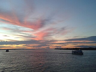
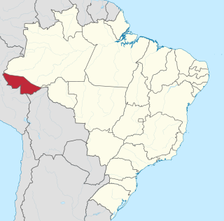
Amazonas is a state of Brazil, located in the North Region in the northwestern corner of the country. It is the largest Brazilian state by area and the 9th largest country subdivision in the world, and the largest in South America, being greater than the areas of Uruguay, Paraguay, and Chile combined. Mostly located in the Southern Hemisphere, it is the third largest country subdivision in the Southern Hemisphere after the Australian states of Western Australia and Queensland. Entirely in the Western Hemisphere, it is the fourth largest in the Western Hemisphere after Greenland, Nunavut and Alaska. It would be the sixteenth largest country in land area, slightly larger than Mongolia. Neighbouring states are Roraima, Pará, Mato Grosso, Rondônia, and Acre. It also borders the nations of Peru, Colombia and Venezuela. This includes the Departments of Amazonas, Vaupés and Guainía in Colombia, as well as the Amazonas state in Venezuela, and the Loreto Region in Peru.
Amazonas may refer to:

Manaus is the capital and largest city of the Brazilian state of Amazonas. It is the seventh-largest city in Brazil, with an estimated 2020 population of 2,219,580 distributed over a land area of about 11,401 km2 (4,402 sq mi). Located at the east center of the state, the city is the center of the Manaus metropolitan area and the largest metropolitan area in the North Region of Brazil by urban landmass. It is situated near the confluence of the Negro and Solimões rivers. It is the only city in the Amazon Rainforest with a population over 1 million people.

Amazonas is a department of Southern Colombia in the south of the country. It is the largest department in area while also having the 3rd smallest population. Its capital is Leticia and its name comes from the Amazon River, which drains the department.

Amazonas State is one of the 23 states into which Venezuela is divided. It covers nearly a fifth of the area of Venezuela, but has less than 1% of Venezuela's population.

Classification of Indigenous peoples of the Americas is based upon cultural regions, geography, and linguistics. Anthropologists have named various cultural regions, with fluid boundaries, that are generally agreed upon with some variation. These cultural regions are broadly based upon the locations of Indigenous peoples of the Americas from early European and African contact beginning in the late 15th century. When Indigenous peoples have been forcibly removed by nation-states, they retain their original geographic classification. Some groups span multiple cultural regions.

Solimões is the name often given to upper stretches of the Amazon River in Brazil from its confluence with the Rio Negro upstream to the border of Peru.

The North Region of Brazil is the largest region of Brazil, corresponding to 45.27% of the national territory. It is the second least inhabited of the country, and contributes with a minor percentage in the national GDP and population. It comprises the states of Acre, Amapá, Amazonas, Pará, Rondônia, Roraima and Tocantins.

The Japurá River or Caquetá River is a river about 2,820 kilometres (1,750 mi) long in the Amazon basin. It rises in Colombia and flows eastward through Brazil to join the Amazon River.

Tabatinga, originally Forte de São Francisco Xavier de Tabatinga, is a municipality in the Três Fronteiras area of Western Amazonas. It is in the Brazilian state of Amazonas. Its population was 67,182 (2020) and its area is 3,225 km2.

The Battle of Riachuelo was a large and decisive naval battle of the Paraguayan War between Paraguay and the Empire of Brazil. By late 1864, Paraguay had scored a series of victories in the war, but on 11 June 1865, its naval defeat by the Brazilians on the Paraná River began to turn the tide in favor of the allies.

Time in Brazil is calculated using standard time, and the country is divided into four standard time zones: UTC−02:00, UTC−03:00, UTC−04:00 and UTC−05:00.
The Amazonas State University is a Brazilian public university operated by the state of Amazonas, located in Manaus, Amazonas, Brazil. It was established in 2001 by a state law that turned the University of Technology of Amazonas into the UEA. In 2011, UEA was ranked the best university of the state in an evaluation made by the Ministry of Education.

Vaupés River is a tributary of the Rio Negro in South America. It rises in the Guaviare Department of Colombia, flowing east through Guaviare and Vaupés Departments. It forms part of the international border between the Vaupés department of Colombia and the Amazonas state of Brazil. On the border it merges with the Papurí River and becomes known as the Uaupés. In 1847 an explorer saw a rapid which hurled its waves 12 or 15 metres in the air, "as if great subaqueous explosions were taking place." The river continues on east through the Alto Rio Negro Indigenous Territory until it flows into the Rio Negro at São Joaquim, Amazonas. Vaupés is a blackwater river.
The Pira-tapuya, or variations like Pira-Tapuia, Piratapuyo, etc., or Tapuya for short, are an indigenous people of the Amazon regions. They live along the Vaupés River in Colombia and in the state of Amazonas, Brazil.