Twin Lakes Township is a township in Carlton County, Minnesota, United States. The population was 1,912 as of the 2000 census.
Mud Lake is an unorganized territory located in Marshall County, Minnesota, United States. In both the 2000 and 2010 U.S. censuses, the unorganized territory recorded a population of 0.

Eagle Mountain is the highest natural point in Minnesota, United States, at 2,301 feet (701 m). It is in northern Cook County in the Boundary Waters Canoe Area Wilderness and Superior National Forest in the Misquah Hills, northwest of Grand Marais. It is a Minnesota State Historic Site.

The Lac qui Parle River is a tributary of the Minnesota River, 118 miles (190 km) long, in southwestern Minnesota in the United States. A number of tributaries of the river, including its largest, the West Branch Lac qui Parle River, also flow in eastern South Dakota. Via the Minnesota River, the Lac qui Parle River is part of the watershed of the Mississippi River, draining an area of 1,156 square miles (2,990 km2) in an agricultural region. Slightly more than two-thirds of the Lac qui Parle watershed is in Minnesota. Lac qui parle means "lake which speaks" in the French language, and was a translation of the Sioux name for Lac qui Parle, a lake on the Minnesota River upstream of the mouth of the Lac qui Parle River.

Lake Louise State Park is a Minnesota state park just north of the Iowa border near the small town of Le Roy in Mower County, Minnesota, directly south of Rochester. It has a 25 acre man-made lake and 1,168 acres (5 km2) of mixed prairie and deciduous forest. It is used for picnics, swimming, camping, hiking, horseback riding, and other outdoor recreation. It is noted for butterfly watching, as some rare species have been seen. It features a picnic shelter which dates to the Public Works Administration era.
The Elk River is an 84.0-mile-long (135.2 km) river in east-central Minnesota in the United States. It is a tributary of the Mississippi River, draining a watershed of 630 square miles (1,600 km2).

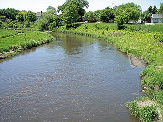
The Buffalo River is a 139-mile-long (224 km) tributary of the Red River of the North in western Minnesota in the United States. Via the Red River, Lake Winnipeg and the Nelson River, it is part of the watershed of Hudson Bay. The river drains an area of 1,189 square miles (3,080 km2).
Bachelor Lake is a lake in Brown County, Minnesota in the northeastern part of Stark township. Covering 79.80 acres, it is an officially protected water of the State of Minnesota. The lake is within the Cottonwood River Major Watershed. The lake’s elevation is 1,004 feet (306 m), and it is zoned as a shoreland area which is regulated as a shoreland management water.

The Chippewa River is a 153-mile-long (246 km) tributary of the Minnesota River in western and southwestern Minnesota in the United States. Via the Minnesota River, it is part of the watershed of the Mississippi River.

Split Rock Creek State Park is a state park of Minnesota, USA, located in Ihlen, or just south of Pipestone.
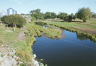
The Pomme de Terre River is a 125-mile-long (201 km) tributary of the Minnesota River in western Minnesota in the United States. Via the Minnesota River, it is part of the watershed of the Mississippi River, draining an area of 875 square miles (2,270 km2) in an agricultural region. The headwaters region of the Pomme de Terre River is the northernmost extremity of the Minnesota River's watershed.
Okabena Creek is a 40-mile-long (64 km) waterway in southern Minnesota. It is a tributary, via the short Diversion Creek, of Heron Lake, the outlet of which flows to the Des Moines River. Okabena Creek begins in Worthington, Minnesota, connecting by a ditch to the outlet of Okabena Lake, then flows northeast past the towns of Brewster and Okabena to the Heron Lake/South Heron Lake system.
Sturgeon River is a 63.6-mile-long (102.4 km) river in the U.S. state of Michigan, flowing mostly southward through Alger County and Delta County counties on the Upper Peninsula.
The Crow Wing Chain of Lakes is a chain of eleven shallow lakes along the Crow Wing River in Hubbard County, Minnesota, approximately 90 miles (140 km) upstream from the Crow Wing's confluence with the Mississippi River. Although connected, there are a few dams between a few of the lakes that are impossible to traverse via motorboats, although they are able to be crossed in canoe.
Nett Lake is an unincorporated community and census-designated place (CDP) in Nett Lake Territory, Saint Louis County, Minnesota, United States; located on the shore of Nett Lake. As of the 2010 census, its population was 284.
Grand Falls is an unincorporated community in Koochiching County, Minnesota, United States.
Island Lake is an unincorporated community in Beltrami County, in the U.S. state of Minnesota.
Schley is an unincorporated community in Cass County, Minnesota, United States, within the Bowstring State Forest and the Chippewa National Forest. It is located between Cass Lake and Bena along U.S. Highway 2 near Forest Road 2958.
Wall Lake is an unincorporated community in Otter Tail County, in the U.S. state of Minnesota.
