Engelen

Last updated
Engelen
Flag of Engelen.svg
Wapen van Engelen.JPG
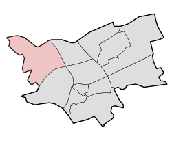
Map - NL - 's-Hertogenbosch - Wijk 12 Engelen.svg
Country Netherlands
Province North Brabant
Municipality 's-Hertogenbosch
Population
 (2008)
5,510
Major roads N59
Website http://www.dorp-engelen.nl/index1.htm
Saint Lambertuschurch Engelen, de Sint Lambertuskerk foto5 2012-10-22 10.35.jpg
Saint Lambertuschurch

Engelen is a village in the Dutch province of North Brabant. It is part of the municipality of 's-Hertogenbosch.

Contents

Location and plan

Engelen is located in the north of North Brabant. It borders the villages Vlijmen and Bokhoven as well as the industrial area De Vutter in `s-Hertogenbosch.

Engelen is divided in several parts. The oldest part consists of the original village. The “new” part consists of the areas that were built before the current expansion took place. The newest part is called plan Haverleij. This consists of castle style housing blocks built around a courtyard / parking lot. Haverleij also includes an 18-hole golf course from Burg Golf. [1] Haverleij borders Engelen Lock on the Dieze Canal. De Haverleij is also closer connecting Engelen to Bokhoven and Vlijmen.

One of the things that are typical for Engelen is the Lake of Engelen  [ nl ] which is a small lake connected to the village by industrial ground De Vutter. January 4, 2007 Engelen came into the news because of a dead baby being found at the lake, which was left there by her parents, till so far the parents have not yet been found. The baby has been given the name “Engel van het Meer,” which means “Angel of the Lake”, referring to the name Engelermeer. [2] Engelen even has its very own anthem named; Kaas is Baas (en: Cheese is boss)

Facilities

Currently, there are many facilities, for example a sport complex with a tennis club, football club (FC Engelen), and a golf club located in De Haverleij, and also a healthcare facility called “De Lage Leun” including a dentist, chemists, and doctor's post. A main meeting place for people and companies in Engelen is the Engelenburcht, a social meeting place and small event hall where yearly activities for the inhabitants of Engelen, Bokhoven, and De Haverleij are held. [3] A primary school De Matrix and Jenaplanschool Antonius Abt. serves Engelen and surrounding areas.

History

Engelen was a separate municipality between 1821 and 1971, when it was merged with 's-Hertogenbosch. [4]

Related Research Articles

Rosmalen Place in North Brabant, Netherlands

Rosmalen is a town in the province of North Brabant, in the south of the Netherlands. The town is located 6 kilometers east of the city of 's-Hertogenbosch and has been part of that municipality since 1996. Its population is around 37,240 on 1 January 2021. In 2005 the town began construction of a new neighbourhood, De Groote Wielen, to include 5,000 homes and other buildings.

s-Hertogenbosch City and municipality in North Brabant, Netherlands

's-Hertogenbosch, colloquially known as Den Bosch, is a city and municipality in the Netherlands with a population of 157,486. It is the capital of the province of North Brabant.

North Brabant Province of the Netherlands

North Brabant, also unofficially called Brabant, is a province in the south of the Netherlands. It borders the provinces of South Holland and Gelderland to the north, Limburg to the east, Zeeland to the west, and the Flemish provinces of Antwerp and Limburg to the south. The northern border follows the Meuse westward to its mouth in the Hollands Diep strait, part of the Rhine–Meuse–Scheldt delta. North Brabant has a population of 2,562,566 as of November 2019. Major cities in North Brabant are Eindhoven, Tilburg, Breda and its provincial capital 's-Hertogenbosch.

Heusden Municipality in North Brabant, Netherlands

Heusden is a municipality and a town in the South of the Netherlands. It is located between the towns of Waalwijk and 's-Hertogenbosch. The municipality of Heusden, including Herpt, Heesbeen, Hedikhuizen, Doeveren, and Oudheusden, merged with Drunen and Vlijmen in 1997, giving the municipality its current form.

Ravenstein, Netherlands City in North Brabant, Netherlands

Ravenstein is a city and a former municipality in the south of the Netherlands, in the province of North Brabant. The former municipality covered an area of 42.68 km². In 2003 it was incorporated into the city of Oss.

Bokhoven

Bokhoven is a village in the Netherlands, in the municipality of 's-Hertogenbosch. It is located about seven kilometres northwest of the city center, on the south bank of the river Maas.

Vlijmen Town in North Brabant, Netherlands

Vlijmen is a town in the Dutch province of North Brabant. It is located in the municipality of Heusden, about 6 km west of 's-Hertogenbosch.

Cuijk en Sint Agatha is a former municipality in the Dutch province of North Brabant. It covered the villages of Cuijk and Sint Agatha.

Dinther Village in North Brabant, Netherlands

Dinther is a village in the Dutch province of North Brabant. It is located in the municipality of Bernheze.

Kessel, North Brabant Village in North Brabant, Netherlands

Kessel is a village in the southern Netherlands. It is located in Oss, North Brabant about 12 km northeast of 's-Hertogenbosch on the river Maas.

Nieuwkuijk Village in North Brabant, Netherlands

Nieuwkuijk is a village in the Dutch province of North Brabant. It is located in the municipality of Heusden, about 10 km west of 's-Hertogenbosch.

Reek, Netherlands Village in North Brabant, Netherlands

Reek is a village in the Dutch province of North Brabant. It is located in the former municipality of Landerd, about 3 km east of Schaijk.

Vlijmen en Engelen was a municipality in the Dutch province of North Brabant. It covered the villages of Vlijmen and Engelen.

Berne Abbey Dutch monastery

Berne Abbey, a Dutch abbey of the Premonstratensians, or Norbertines, in Heeswijk, North Brabant, is the oldest extant religious community in the Netherlands. It has 27 brothers and priests.

The following is a timeline of the history of the municipality of 's-Hertogenbosch, Netherlands.

Moerputten Bridge Bridge

The Moerputten Bridge is a former railway bridge near the Dutch city 's-Hertogenbosch. It spans the peat lake 'Lange Putten'.

Bokhoven Castle

Bokhoven Castle was a big defendable castle in Bokhoven, the Netherlands. A moat and part of the northern wall of the outer bailey are all that reminds of the castle.

Loon op Zand Castle Castle in the Netherlands

Loon op Zand Castle, is a castle in Loon op Zand, in the Dutch province of North Brabant. The current building looks like a manor, but is actually the keep of a medieval castle.

Empel en Meerwijk Castle

Empel en Meerwijk Castle was a medieval castle just north of 's-Hertogenbosch. All that's left is a terrain where the castle outlines have been visualized.

Lage Zwaluwe-s-Hertogenbosch railway

The Lage Zwaluwe-'s-Hertogenbosch railway or Langstraatspoorlijn is a defunct and partially open railway line in North Brabant, the Netherlands. It ran through the Langstraat from Lage Zwaluwe railway station via Waalwijk to 's-Hertogenbosch railway station. Part of the line had been repurposed for recreation. It has the nickname Halvezolenlijntje. The Moerputten Bridge is a unique piece of engineering.

References

  1. "BurgGolf". burggolf.nl.
  2. "Home › Vermist". vermist.nl. Archived from the original on 2011-07-20.
  3. "Het informatieportaal voor Engelen, Bokhoven en de Haverleij door dorp-engelen.nl". Archived from the original on 2008-08-10. Retrieved 2008-11-07.
  4. Ad van der Meer and Onno Boonstra, Repertorium van Nederlandse gemeenten , KNAW, 2011.

Coordinates: 51°43′N5°16′E / 51.717°N 5.267°E / 51.717; 5.267