Related Research Articles
Bergen County is the most populous county in the U.S. state of New Jersey. As of the 2019 Census estimate, the county's population was 932,202, an increase of 3.0% from the 2010 census, which in turn represented an increase of 20,998 (2.4%) from the 884,118 counted in the 2000 Census. Located in the northeastern corner of New Jersey and its Gateway Region, Bergen County is part of the New York City Metropolitan Area and is directly across the Hudson River from Manhattan, to which it is connected by the George Washington Bridge.
Route 5 is a 3.18-mile (5.12 km) state highway located entirely in Bergen County, New Jersey, United States. It runs from U.S. Route 1/9 (US 1-9) in Ridgefield east down the New Jersey Palisades to end at County Route 505 at the Hudson River in Edgewater. The route is a two- to four-lane undivided highway its entire length, passing mostly through wooded residential neighborhoods. The route passes under Route 63 in Palisades Park, with access to that route provided by Bergen Boulevard, and intersects the southern terminus of Route 67 in Fort Lee.
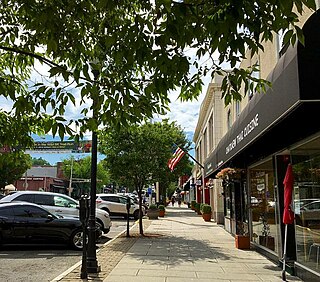
Englewood is a city in Bergen County, New Jersey, United States. As of the 2010 United States Census, the city had a total population of 27,147, reflecting an increase of 944 (+3.6%) from the 26,203 counted in the 2000 Census, which had in turn increased by 1,353 (+5.4%) from the 24,850 counted in the 1990 Census.

Teaneck is a township in Bergen County in New Jersey, United States, and a suburb in the New York metropolitan area. As of the 2010 United States Census, the township's population was 39,776, reflecting an increase of 516 (+1.3%) from the 39,260 counted in the 2000 Census, which had in turn increased by 1,435 (+3.8%) from the 37,825 counted in the 1990 Census. As of 2010 it was the second-most populous among the 70 municipalities in Bergen County, behind Hackensack, which had a population of 43,010.
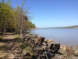
Overpeck Creek is a tributary of the Hackensack River, approximately 8 miles (13 km) long, in Bergen County in northeastern New Jersey in the United States. The lower broad mouth of the creek is part of the extended tidal estuary of the lower Hackensack and of the adjacent wetland region known as the New Jersey Meadowlands.

The Palisades, also called the New Jersey Palisades or the Hudson River Palisades, are a line of steep cliffs along the west side of the lower Hudson River in Northeastern New Jersey and Southeastern New York in the United States. The cliffs stretch north from Jersey City about 20 miles (32 km) to near Nyack, New York, and visible at Haverstraw, New York. They rise nearly vertically from near the edge of the river, and are about 300 feet (90 m) high at Weehawken, increasing gradually to 540 feet (160 m) high near their northern terminus. North of Fort Lee, the Palisades are part of Palisades Interstate Park and are a National Natural Landmark.
Lodi Township was a township that existed in Bergen County, New Jersey, United States, from 1826 to 1935.
Harrington Township was a township that existed in Bergen County, New Jersey, United States, from 1775 until 1916. It was named after the Haring family, who were early settlers to the region.

New Jersey's 9th congressional district is represented in Congress by Democrat Bill Pascrell, who resides in Paterson. Congressman Pascrell was first elected in 1996 from the old 8th district, defeating incumbent William J. Martini. The 9th district consists largely of municipalities in Bergen County and Passaic County.
Ridgefield Township was a township that existed in Bergen County, New Jersey. The township was created in 1871, when Hackensack Township was trisected to form Palisades Township in the northernmost third, Englewood Township in the central strip and Ridgefield Township encompassing the southernmost portion, stretching from the Hudson River on the east to the Hackensack River, with Hudson County to the south. Much of the area had been during the colonial area known as the English Neighborhood. As described in the 1882 book, History of Bergen and Passaic counties, New Jersey,
Ridgefield is the first township in Bergen County which the traveler enters in passing up the Palisades. His first impressions are much like those of old Hendrick Hudson in speaking of a wider extent of country: "A very good land to fall in with, and a pleasant land to see." The valley of the Hackensack invited early settlers in the seventeenth century, and the valley of the Overpeck Creek, a navigable arm of the Hackensack, also attracted settlers quite as early in this direction. Sloops and schooners can pass up this creek nearly to the northern boundary of the township. Ridgefield is bounded on the north by Englewood, on the east by the Hudson, on the south by Hudson County, and on the west by the Hackensack River. The southern boundary is less than two miles in extent, and the northern less than four, and the length of the township from north to south does not exceed four miles. Bellman's Creek, forming part of the southern boundary, the Hackensack, the Overpeck, the Hudson, with more than a dozen other smaller streams and rivulets, bountifully supply the whole township with water. From the western border of the Palisades the land descends to the Overpeck, forming a most beautiful valley, with the land again rising to a high ridge midway between the Overpeck and the Hackensack. From this long ridge, extending far to the north beyond this township, it took its name of Ridgefield.
The New York, Susquehanna and Western, formerly the Midland Railroad, the Jersey City and Albany Railroad, and the Northern Railway of New Jersey—all running northward through the township— afford ample railroad accommodations. The Susquehanna enters the township at Bellman's Creek, and the Northern at about one hundred feet south of the creek, and at a point north and east of the Susquehanna. The Albany road in this locality is not yet constructed, diverging at present from the track of the Susquehanna between Little Ferry and Bogota stations. It has, however, an independent line projected and now under construction to New York City.
Early Settlements. Ridgefield embraces the earliest settlements in the ancient township of Hackensack, antedating even the organization of that township in 1693, and of the county of Bergen in 1675. There seems to have been no town or village compactly built, like the village of Bergen, but there were settlements both of Dutch and English in and about what was subsequently known as English Neighborhood prior to 1675. The Westervelts, the Zimcrmans, the Bantas, and the Blauvelts, all coming from Holland, settled in the middle of the seventeenth century in that locality. The ancestors of Jacob P. Westervelt, now of Hackensack Village, with himself, were born in English Neighborhood. His father was born there in 1776, and was the son of Christopher Westervelt, who was born there certainly as early as 1690, and he was the son of the original ancestor of this family, who came from Holland and settled on Overpeck Creek, within the present limits of Ridgefield township, probably about 1670.
Hackensack Township was a township that was formed in 1693 within Bergen County, New Jersey, United States. The township was created by the New Jersey Legislature as one of the first group of townships in New Jersey. Bergen County, which had been created in 1682, was thus split into two parts: Hackensack Township to the north, and Bergen Township to the south.
Palisades Township was a township that existed in Bergen County, New Jersey, United States. The township was in existence from 1871 to 1922.
Bergen Township was a township that existed in the U.S. state of New Jersey, from 1661 to 1862, first as Bergen, New Netherland, then as part Bergen County, and later as part of Hudson County. Several places still bear the name: the township of North Bergen; Bergen Square, Old Bergen Road, Bergen Avenue, Bergen Junction, Bergen Hill and Bergen Arches in Jersey City; Bergen Point in Bayonne; and Bergenline Avenue and Bergen Turnpike in North Hudson.
Bergen Township was a township that existed in Bergen County, New Jersey. The township was created on February 21, 1893, from the southern section of Lodi Township :
Be It Enacted by the Senate and General Assembly of Portion to be the State of New Jersey, That all that portion of the township of Lodi, in the county of Bergen, lying within the following boundaries, to wit, beginning at the intersection Boundaries, of the northerly boundary of the township of Boiling Springs, in the county of Bergen, with the middle of the Passaic river; running thence easterly along the northerly boundary of said township of Boiling Springs to the middle of the Hackensack River; thence, northerly along the middle of the Hackensack river to a point opposite the mouth of a creek emptying into said river, commonly known as the Upper Mudabock creek; thence, westerly in a straight line to a point where the northerly line of the public road leading from Moonachie to Wood-Ridge, commonly known as the Mousetown road, intersects the westerly line of the public road commonly known as the Moonachie road; thence, westerly along the northerly line of the Mousetown road to the westerly line of the Riser ditch; thence, northerly along the westerly line of said ditch to the northerly line of lands now or formerly belonging to the estate of Richard Vreeland; thence, westerly along said line of lands to the Polifly road; thence, still westerly in the same course as last described, along the northerly line of lands now or formerly belonging to the estate of Benjamin Cox to a line commonly known as the Polifly line; thence, northerly along said line to the southerly line of the public road leading from said Polifly road to the public road commonly known as the River road; thence westerly along the southerly line of said road leading from the Polifly road to the River road; thence, still westerly in line with the last course of the southerly line of said road to the middle of the Saddle river; thence, downstream through the middle of the Saddle river to the middle of the Passaic thence, down stream through the middle of said to the place of beginning, shall be and hereby is set off from the township Lodi, in the county of Bergen, and made a separate township, to be known by the name of the township of Bergen.
Overpeck Township was a township that existed in Bergen County, New Jersey, United States, from 1897 to 1938.

The Hackensack Plank Road, also known as Bergen Turnpike, was a major artery which connected the cities of Hoboken and Hackensack, New Jersey. Like its cousin routes, the Newark Plank Road and Paterson Plank Road, it travelled over Bergen Hill and across the Hackensack Meadows from the Hudson River waterfront to the city for which it was named. It was originally built as a colonial turnpike road as Hackensack and Hoboken Turnpike. The route mostly still exists today, though some segments are now called the Bergen Turnpike. It was during the 19th century that plank roads were developed, often by private companies which charged a toll. As the name suggests, wooden boards were laid on a roadbed in order to prevent horse-drawn carriages and wagons from sinking into softer ground on the portions of the road that passed through wetlands. The company that built the road received its charter on November 30, 1802. The road followed the route road from Hackensack to Communipaw that was described in 1679 as a "fine broad wagon-road."
Harrison Township was created by an act of the New Jersey Legislature on April 13, 1840, and was part of Hudson County which was created from portions of Bergen County, on February 22, 1840.

Bergen Neck is a name for the peninsula between the Upper New York Bay and the Newark Bay in the Hudson County, New Jersey municipalities of Bayonne and Jersey City. Its southernmost tip, Bergen Point, is separated from Staten Island by the Kill van Kull, which is crossed by the Bayonne Bridge.
The English Neighborhood was the colonial-era name for the towns in eastern Bergen County, New Jersey, along the Hudson Palisades between the Hudson River and the Hackensack River, particularly around its main tributary, Overpeck Creek. The region had been part of the Dutch New Netherland colony of Bergen, whose main town was located at Bergen Square in today's Jersey City. The name speaks to the geography of the region, bergen being the Dutch word for hills. Earlier attempts at settlement at Achter Col and Vriessendael had been compromised in conflicts with the precolonial population, phratries of the Lenape known by their exonyms, the Hackensack and the Tappan.
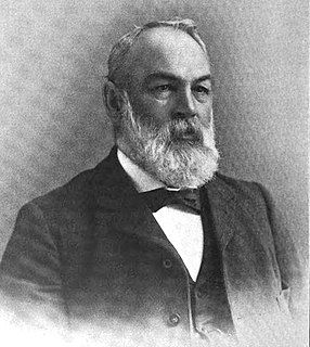
William Weaver Bennett chaired the three-man township committee at the formation of Teaneck, New Jersey, making him the first Mayor of Teaneck, New Jersey.
References
Coordinates: 40°54′N73°58′W / 40.90°N 73.97°W
| This New Jersey–related article is a stub. You can help Wikipedia by expanding it. |