Tobago is an island and ward within the Republic of Trinidad and Tobago. It is located 35 kilometres (22 mi) northeast of the larger island of Trinidad and about 160 kilometres (99 mi) off the northeastern coast of Venezuela. It lies to the southeast of Grenada.
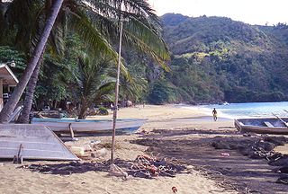
Castara is a seaside village on the leeward (north) coast of the island of Tobago, the smaller of the two islands in the twin-island Republic of Trinidad and Tobago. Castara's economy is dependent primarily on fishing and agriculture, with tourism playing an increasingly important role since the 1990s.

Chacachacare is an island in the Republic of Trinidad and Tobago, located at 10° 41' north latitude and 61° 45' west longitude. The island is 360 hectares in area.

Saint Giles Island is the largest in a group of small islands off the northeast tip of Tobago. It is very steep sided and hosts tropical dry forest and wind-swept littoral scrub.

Charlotteville is a village lying on the northeastern tip of Tobago on Man-o-War Bay.

Grenadines is an administrative parish of Saint Vincent and the Grenadines, comprising the islands of the Grenadines other than those belonging to Grenada. The capital is Port Elizabeth. It's the only parish in the country that's not located on the main island.
Main Ridge is the main mountainous ridge on the island of Tobago, Trinidad and Tobago. It is a 29-kilometre (18 mi) chain of hills which runs from southwest to northeast between the Caribbean Sea and the Southern Tobago fault system and reaches a maximum height of 572 m (1,877 ft). The Main Ridge Forest Reserve, which was legally established in 1776, is one of the oldest protected areas in the world. It is a popular site for birdwatching and ecotourism. Main Ridge provides important habitat for native plants and animals, including several species endemic to Tobago.
Bacolet is a town and suburb in the city of Scarborough on the island of Tobago, Republic of Trinidad and Tobago. The town itself lies beneath Fort King George at the Bacolet Bay, just outside the city center to the south-east of the island's capital. It is one of the most developed parts of Tobago, and much of the island's high society lives there. There are also many villas and hotels for tourists.

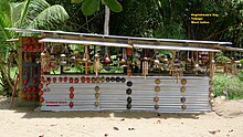
Pigeon Point is also known as Pigeon Point Heritage Park (PPHP) and is often considered Tobago’s most beautiful beach and is home to the world famous thatch-roofed jetty which has become an internationally recognised signature of Tobago. The resort includes a long stretch of white sand beach with warm aquamarine waters. There are excellent beach facilities such as bathrooms, showers and beach-chair rentals as well as bars and a restaurant. Tourist amenities include souvenir and water-sports shops.

Carenage is a town in the Republic of Trinidad and Tobago. It is located in northwestern Trinidad, and is administered by the Diego Martin Regional Corporation. Located close to Chaguaramas, it is more of a residential area than a commercial or industrial locale.

Asilomar State Marine Reserve (SMR) is one of four small marine protected areas (MPAs) located near the cities of Monterey and Pacific Grove, at the southern end of Monterey Bay on California’s central coast. The four MPAs together encompass 2.96 square miles (7.7 km2). The SMR protects all marine life within its boundaries. Fishing and take of all living marine resources is prohibited.

Stewarts Point State Marine Reserve (SMR) and Stewarts Point State Marine Conservation Area (SMCA) are two adjoining marine protected areas that extend offshore from about a mile south of Black Point to Fisk Mill Cove, in Sonoma County on California’s north central coast. The marine protected areas cover 25.22 square miles (65.3 km2). Stewarts Point SMR prohibits the take of all living marine resources. Stewarts Point SMCA prohibits the take of all living marine resources, except recreational shore based take of marine aquatic plants, marine invertebrates, finfish by hook and line, surf smelt by beach net, and species authorized by Title 14 Section 28.80 by hand-held dip net.

Carmel Pinnacles State Marine Reserve (SMR) is a marine protected area in Carmel Bay including a unique underwater pinnacle formation with adjacent kelp forest, submarine canyon head, and surfgrass. Carmel Bay is adjacent to the city of Carmel-by-the-Sea and is near Monterey, on California's central coast.

Lovers Point State Marine Reserve (SMR) is one of four small marine protected areas located near the cities of Monterey and Pacific Grove, at the southern end of Monterey Bay on California’s central coast. The four MPAs together encompass 2.96 square miles (7.7 km2). The SMR protects all marine life within its boundaries. Fishing and take of all living marine resources is prohibited.

Pacific Grove Marine Gardens State Marine Conservation Area is one of four small marine protected areas located near the cities of Monterey and Pacific Grove, at the southern end of Monterey Bay on California’s central coast. The four MPAs together encompass 2.96 square miles (7.7 km2). Within the SMCA fishing and take of all living marine resources is prohibited except the recreational take of finfish and the commercial take of giant and bull kelp by hand under certain conditions. According to the Frommer's guide, the Marine Gardens area is "renowned for ocean views, flowers, and tide-pool seaweed beds."

The Quanzhou Ship (泉州湾古船), or Quanzhou wreck, was a 13th-century Chinese seagoing sailing junk that sank near the city of Quanzhou in Fujian Province, and was discovered in 1973. It remains one of the most important marine archaeology finds in China, and is an important piece of physical evidence about the shipbuilding techniques of the Song China and the international maritime trade of the period.
Mount Sladen is a conspicuous pyramid-shaped mountain, 890 m, standing 1.5 nautical miles (2.8 km) northeast of Saunders Point in eastern Coronation Island, in the South Orkney Islands. Surveyed by the Falkland Islands Dependencies Survey (FIDS) in 1948–49. Named by the United Kingdom Antarctic Place-Names Committee (UK-APC) for Dr. William J.L. Sladen of the FIDS, medical officer and biologist at Hope Bay in 1948, and at Signy Island in 1950. During the 1960s and 1970s, Dr. Sladen was chief United States Antarctic Research Program (USARP) investigator concerned with studies of penguins at Cape Crozier, Ross Island.

Cape Tisan is a headland on the Mediterranean Sea coast of Mersin Province, Turkey. Τhe name is a distorted form of Ἀφροδισιᾶν.
Courland Bay may refer to: