Environment of Wyoming

Last updated

Wyoming straddles the Continental Divide, and its abrupt topographic relief includes alternating basins and mountain ranges. Major mountain ranges include the Beartooth, Gros Ventre, Teton, Wind River, Bighorn, Sierra Madre, and Medicine Bow. Internal basins and eastern plains are rolling to flat, and in the east are the Great Plains.

Contents

Typical vegetation includes sagebrush, greasewood, and saltbush shrubs in the intermountain basins, grasses on the Great Plains, juniper and mountain mahogany in the foothills, and forest and alpine meadows in the mountains.

The state lies within the US Environmental Protection Agency's Region 8. [1]

Agriculture in Wyoming

The state of Wyoming, also known as the Cowboy State, has 30.2 million acres dedicated to farm land alone. Being one of the top agricultural states in the U.S, Wyoming has 11,000 farms with the average farm size being 2,726 acres. [2] “In 2001 agricultural lands in Wyoming produced 652.7 million pounds of beef, 31.2 million pounds of sheep and lamb, 3.0 million bushels of wheat, 7.0 million bushels of barley, 6.4 million bushels of corn, and 1.9 million tons of hay” [2] The top crops grown in Wyoming are hay, barley, wheat, beans, sugar beets, and corn. The largest commodity is by far the beef industry in Wyoming.

Farm Land

With approximately 30.2 million acres in agricultural production, Wyoming has eight times more land in agricultural production than the national average. [2] About 27.18 million acres (90%) of the total agricultural land in Wyoming is grazing land; and approximately 9% is cropland (Foulke, Coupal, and Taylor 5). The majority of the agricultural land in Wyoming is dedicated to agriculture operations which owns 5,000 or more acres. [2]

Livestock

In 2008, the beef industry brought in around $599 million. The beef industry is the largest commodity in Wyoming. [3] According to The Western Regional Science Association, in 2001, livestock sales brought in 652.7 million pounds of beef and 31.2 million pounds of sheep and lamb. Sheep ranchers in 2007 brought in 3,124,299 pounds of wool. On a statewide basis Wyoming was ranked fourth on lamb and sheep sales for a total amount of 411,952 head. Also in 2007, inventory was taken and the total hog, horses and colonies of bees was: 107,180 hogs and pigs, 80,476 horses and 45,633 colonies of bees. [3]

Crops

In Wyoming, the main crops that are grown are: hay, barley, wheat, beans and corn. Bringing in $65 million in 2008, wheat is the largest crop commodity. The second largest crop commodity is barley, bringing in $32 million and $31 million for wheat sales. Nationwide, Wyoming is 8th in barley, 20th in hay and 33rd in wheat production. [3] Approximately 3.0 million bushels of wheat, 7.0 million bushels of barley, 6.4 million bushels of corn, and 1.9 million tons of hay were produced in 2001 alone.

Summary

Agriculture plays a big role in the state of Wyoming. Land in Wyoming that is related to agriculture takes up about 55 percent of the total land in Wyoming [2] In 2001, agriculture profits were up to $185.6 million in net farm income. This net income of $185.6 million sustained about 12,345 jobs [2] “The State also ranks number 1 in terms of average size of agriculture enterprises and number 8 in terms of total land in agriculture”

Land Use in Wyoming

Due to Wyoming’s low population, land use is available for many different options: from mineral refining, to national forests, national parks, open ranges, state parks, BLM (Bureau of Land Management), and privately owned land. Referring to the NETSTATE website, Wyoming is separated by the Continental Divide, and can be classified into three separate geographical land terms; the Rocky Mountains, the Great Plains, and Intermontane Basins. [4] The major mountain ranges would consist of the Beartooth, Teton, Bighorn, Medicine Bow, Gros Ventre, Wind River, and Sierra Madre, and holds the lowlands of the Great Plains to the east. The US Department of Agriculture counts Wyoming with 22 state parks, four national forests, and one national grassland. This gives Wyoming a vast amount of public land for recreation and wildlife habitat. [5]

Green Mountain Common Allotment

According to Geoffrey O’Gara of High Country News, The Green Mountain Common Allotment was once one of the largest unfenced open ranges in North America. O’Gara claims the allotment contains over 500,000 acres, split north to south by the Continental Divide, spanning 60 miles by 20 miles and is a mix of private and public land. It is primarily used for grazing by 17 different ranching controls and is considered on the high plains of Wyoming, where the habitat harbors wild horses, cattle, wildlife, shrubbery, and grasslands. The range has recently been getting pressures to divide it, fence it, and prevent grazing damage and protect natural ecosystems, as well as fencing for developments and privatization. Opposition says the Green Mountain Common Allotment needs to stay unfenced not only for sentiment of the “old west,” but also to prevent such things as tangled pronghorn and sage grouse, as once seen in the tragedy of the Red Rim fence disaster. [6]

Wyoming Natural Energy and Resources

In 2010, the Wyoming Bureau of Land Management released to the public their annual report. In the annual report, they disseminate information about the natural energy and resources held in the state, many in which they mine and refine from the land and environment. The report claims Wyoming “leads the country in coal production with the 10 largest producing coal mines in the United States, providing coal to 35 states and generating nearly 40 percent of the nation’s electricity”. [7] The report also says that the state holds about 70% of the world’s discovered bentonite supply. [7] In addition, Wyoming also has multiple wind farm applications and 34 turbines operating on the Foote Creek Rim wind farm on BLM administered land. Even with all wind turbines, farms, and plants considered, Wyoming has only capitalized on one percent of the possible wind energy. [7] One other resource being capitalized, Wyoming mines uranium and is accountable for nearly 31% of national production. The Nuclear Regulatory Commission is reviewing four uranium plans of operation, each of which are situated at the Casper Field Office, the Rawlins Field Office, the Lander Field Office, and the Buffalo Field Office. [7]

Wild Horse Herds

The Bureau of Land Management reports that the Wild Free-Roaming Horse and Burros Act of 1971 governs and protects the free ranging and unbranded horses roaming on BLM land of the western United States. They allow the animals to be adopted when population levels overflow the manageable level. [8] The BLM Wyoming estimates the wild horse population was just shy of 4000 horses (3,985 claimed) current in 2010. They claim the state population management level is in a range of 2,490 to 3,725 horses, thus they gathered 1,804 horses, removed 1,238, and used fertility control on 224 mares before releasing the mares back into the wild. Within the horses captured from the wild, 134 were adopted in 2010. [7]

Habitat Changes

In January 2009, the Wyoming Game and Fish Department released their Strategic Habitat Plan, covering many topics on preserving the Wyoming wildlife habitat and providing coexistence with wildlife and civilization. The plan is partly designed to start assessing the necessary steps required to keep up with the natural changes in the climate, environment, and ecosystems. According to the plan, predictions gathered in 2007 by a panel on climate change deem average air temperatures to change in North America by 1-3 °C between the years 2010 and 2039. [9] Correlating with climate change, scientists also predict that new plant and animal congregations and associations will change the environment and the ecosystem . For more natural changes happening readily in the ecosystems and habitat, the plan stresses that insects such as bark beetles and budworms combined with drought are significantly changing the Wyoming landscape. [9]

Climate statistics for selected cities

Climate data for Cheyenne Regional Airport, Wyoming (1991–2020 normals, [lower-alpha 1] extremes 1872−present [lower-alpha 2] )
MonthJanFebMarAprMayJunJulAugSepOctNovDecYear
Record high °F (°C)70
(21)
71
(22)
77
(25)
84
(29)
91
(33)
100
(38)
100
(38)
98
(37)
96
(36)
85
(29)
75
(24)
70
(21)
100
(38)
Mean maximum °F (°C)58.4
(14.7)
60.0
(15.6)
68.6
(20.3)
74.8
(23.8)
82.7
(28.2)
90.8
(32.7)
94.4
(34.7)
92.5
(33.6)
88.1
(31.2)
78.5
(25.8)
67.2
(19.6)
58.8
(14.9)
95.2
(35.1)
Average high °F (°C)40.0
(4.4)
40.6
(4.8)
49.1
(9.5)
54.8
(12.7)
64.4
(18.0)
76.7
(24.8)
84.1
(28.9)
82.0
(27.8)
73.3
(22.9)
59.1
(15.1)
47.5
(8.6)
39.3
(4.1)
59.2
(15.1)
Daily mean °F (°C)29.2
(−1.6)
29.5
(−1.4)
37.1
(2.8)
42.8
(6.0)
52.3
(11.3)
63.1
(17.3)
70.1
(21.2)
68.1
(20.1)
59.6
(15.3)
46.5
(8.1)
36.1
(2.3)
28.7
(−1.8)
46.9
(8.3)
Average low °F (°C)18.4
(−7.6)
18.4
(−7.6)
25.1
(−3.8)
30.8
(−0.7)
40.2
(4.6)
49.4
(9.7)
56.1
(13.4)
54.3
(12.4)
45.8
(7.7)
33.9
(1.1)
24.7
(−4.1)
18.1
(−7.7)
34.6
(1.4)
Mean minimum °F (°C)−5.8
(−21.0)
−3.8
(−19.9)
6.6
(−14.1)
16.2
(−8.8)
26.6
(−3.0)
38.5
(3.6)
47.1
(8.4)
44.8
(7.1)
31.9
(−0.1)
16.4
(−8.7)
3.2
(−16.0)
−4.7
(−20.4)
−13.0
(−25.0)
Record low °F (°C)−38
(−39)
−34
(−37)
−21
(−29)
−8
(−22)
8
(−13)
25
(−4)
33
(1)
25
(−4)
8
(−13)
−5
(−21)
−21
(−29)
−28
(−33)
−38
(−39)
Average precipitation inches (mm)0.35
(8.9)
0.52
(13)
0.96
(24)
1.79
(45)
2.44
(62)
2.16
(55)
2.11
(54)
1.52
(39)
1.47
(37)
1.00
(25)
0.61
(15)
0.48
(12)
15.41
(391)
Average snowfall inches (cm)6.3
(16)
9.0
(23)
9.7
(25)
11.3
(29)
3.4
(8.6)
0.0
(0.0)
0.0
(0.0)
0.0
(0.0)
1.0
(2.5)
5.9
(15)
7.5
(19)
8.8
(22)
62.9
(160)
Average precipitation days (≥ 0.01 in)5.16.97.910.612.910.710.510.37.37.16.26.0101.5
Average snowy days (≥ 0.1 in)5.97.36.86.81.90.10.00.00.53.25.86.745.0
Average relative humidity (%)52.554.656.154.355.853.551.351.451.550.053.654.053.2
Mean monthly sunshine hours 190.7202.6253.1271.9291.9303.2317.5297.4262.3237.0178.8175.42,981.8
Percent possible sunshine 64686868656769707069606167
Source: NOAA (relative humidity and sun 1961−1990) [11] [12] [13]
Climate data for Casper, Wyoming (Casper-Natrona County International Airport), 1991–2020 normals, extremes 1948–present
MonthJanFebMarAprMayJunJulAugSepOctNovDecYear
Record high °F (°C)60
(16)
68
(20)
77
(25)
84
(29)
95
(35)
102
(39)
104
(40)
102
(39)
100
(38)
87
(31)
73
(23)
66
(19)
104
(40)
Mean maximum °F (°C)50.8
(10.4)
55.1
(12.8)
68.1
(20.1)
76.9
(24.9)
85.4
(29.7)
94.3
(34.6)
99.1
(37.3)
96.9
(36.1)
91.9
(33.3)
80.1
(26.7)
65.7
(18.7)
52.8
(11.6)
99.5
(37.5)
Average high °F (°C)35.2
(1.8)
37.8
(3.2)
48.8
(9.3)
56.3
(13.5)
66.8
(19.3)
79.6
(26.4)
89.0
(31.7)
86.7
(30.4)
75.6
(24.2)
59.7
(15.4)
45.9
(7.7)
34.7
(1.5)
59.7
(15.4)
Daily mean °F (°C)25.1
(−3.8)
26.6
(−3.0)
35.8
(2.1)
42.3
(5.7)
52.0
(11.1)
62.5
(16.9)
71.0
(21.7)
69.0
(20.6)
58.9
(14.9)
45.3
(7.4)
34.0
(1.1)
24.8
(−4.0)
45.6
(7.6)
Average low °F (°C)15.0
(−9.4)
15.4
(−9.2)
22.7
(−5.2)
28.2
(−2.1)
37.1
(2.8)
45.4
(7.4)
53.0
(11.7)
51.4
(10.8)
42.2
(5.7)
30.9
(−0.6)
22.0
(−5.6)
14.8
(−9.6)
31.5
(−0.3)
Mean minimum °F (°C)−12.2
(−24.6)
−10.0
(−23.3)
3.3
(−15.9)
13.8
(−10.1)
24.5
(−4.2)
37.4
(3.0)
42.9
(6.1)
40.0
(4.4)
29.1
(−1.6)
13.9
(−10.1)
−2.6
(−19.2)
−11.5
(−24.2)
−20.8
(−29.3)
Record low °F (°C)−40
(−40)
−32
(−36)
−25
(−32)
−6
(−21)
16
(−9)
25
(−4)
30
(−1)
29
(−2)
16
(−9)
−9
(−23)
−27
(−33)
−42
(−41)
−42
(−41)
Average precipitation inches (mm)0.49
(12)
0.56
(14)
0.84
(21)
1.41
(36)
2.21
(56)
1.34
(34)
1.19
(30)
0.79
(20)
0.95
(24)
1.19
(30)
0.64
(16)
0.61
(15)
12.22
(308)
Average snowfall inches (cm)9.0
(23)
10.9
(28)
10.3
(26)
10.5
(27)
2.6
(6.6)
0.1
(0.25)
0.0
(0.0)
0.0
(0.0)
1.5
(3.8)
7.0
(18)
8.9
(23)
11.0
(28)
71.8
(183.65)
Average precipitation days (≥ 0.01 in)6.06.98.010.311.08.56.85.86.87.66.27.090.9
Average snowy days (≥ 0.1 in)6.17.56.86.01.60.00.00.00.53.85.67.645.5
Average ultraviolet index 234681010964215
Source 1: NOAA [14]
Source 2: National Weather Service [15]

See also

Notes

  1. Mean monthly maxima and minima (i.e. the expected highest and lowest temperature readings at any point during the year or given month) calculated based on data at said location from 1991 to 2020.
  2. Official records for Cheyenne kept at the City Office from January 1871 to August 1935 and at Cheyenne Regional since September 1935. [10]

Related Research Articles

<span class="mw-page-title-main">Wyoming</span> U.S. state

Wyoming is a state in the Mountain West subregion of the Western United States. It is bordered by Montana to the north and northwest, South Dakota and Nebraska to the east, Idaho to the west, Utah to the southwest, and Colorado to the south. With a population of 576,851 in the 2020 United States census, Wyoming is the least populous state despite being the 10th largest by area, with the second-lowest population density after Alaska. The state capital and most populous city is Cheyenne, which had an estimated population of 63,957 in 2018.

<span class="mw-page-title-main">Great Plains</span> Flat expanse in western North America

The Great Plains, sometimes simply "the Plains", is a broad expanse of flatland in North America. It is located west of the Mississippi River and east of the Rocky Mountains, much of it covered in prairie, steppe, and grassland. It is the southern and main part of the Interior Plains, which also include the tallgrass prairie between the Great Lakes and Appalachian Plateau, and the Taiga Plains and Boreal Plains ecozones in Northern Canada. The term Western Plains is used to describe the ecoregion of the Great Plains, or alternatively the western portion of the Great Plains.

<span class="mw-page-title-main">Bureau of Land Management</span> Agency within the US Department of the Interior

The Bureau of Land Management (BLM) is an agency within the United States Department of the Interior responsible for administering federal lands. Headquartered in Washington DC, and with oversight over 247.3 million acres (1,001,000 km2), it governs one eighth of the country's landmass.

<span class="mw-page-title-main">Agriculture in the United States</span> Major industry in the United States

Agriculture is a major industry in the United States, which is a net exporter of food. As of the 2017 census of agriculture, there were 2.04 million farms, covering an area of 900 million acres (1,400,000 sq mi), an average of 441 acres per farm.

<span class="mw-page-title-main">Interior Plains</span> Physiographic and geologic region of the United States and Canada

The Interior Plains is a vast physiographic region that spreads across the Laurentian craton of central North America, extending along the east flank of the Rocky Mountains from the Gulf Coast region to the Arctic Beaufort Sea. In Canada, it encompasses the Canadian Prairies separating the Canadian Rockies from the Canadian Shield, as well as the Boreal Plains and Taiga Plains east of the Mackenzie and Richardson Mountains; while in the United States, it includes the Great Plains of the West/Midwest and the tallgrass prairie region to the south of the Great Lakes extending east to the Appalachian Plateau region.

<span class="mw-page-title-main">Mustang</span> Free-roaming horse of the Western US

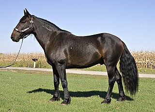
The mustang is a free-roaming horse of the Western United States, descended from horses brought to the Americas by the Spanish. Mustangs are often referred to as wild horses, but because they are descended from once-domesticated animals, they are actually feral horses. The original mustangs were Colonial Spanish horses, but many other breeds and types of horses contributed to the modern mustang, now resulting in varying phenotypes. Some free-roaming horses are relatively unchanged from the original Spanish stock, most strongly represented in the most isolated populations.

<span class="mw-page-title-main">Agriculture in Australia</span> Overview of agriculture in Australia

Although Australia is mostly arid, the nation is a major agricultural producer and exporter, with over 325,300 employed in agriculture, forestry and fishing as of February 2015. Agriculture and its closely related sectors earn $155 billion-a-year for a 12% share of GDP. Farmers and grazers own 135,997 farms, covering 61% of Australia's landmass. Across the country there is a mix of irrigation and dry-land farming. The success of Australia to become a major agricultural power despite the odds is facilitated by its policies of long-term visions and promotion of agricultural reforms that greatly increased the country's agricultural industry.

The history of agriculture in the United States covers the period from the first English settlers to the present day. In Colonial America, agriculture was the primary livelihood for 90% of the population, and most towns were shipping points for the export of agricultural products. Most farms were geared toward subsistence production for family use. The rapid growth of population and the expansion of the frontier opened up large numbers of new farms, and clearing the land was a major preoccupation of farmers. After 1800, cotton became the chief crop in southern plantations, and the chief American export. After 1840, industrialization and urbanization opened up lucrative domestic markets. The number of farms grew from 1.4 million in 1850, to 4.0 million in 1880, and 6.4 million in 1910; then started to fall, dropping to 5.6 million in 1950 and 2.2 million in 2008.

The grain trade refers to the local and international trade in cereals and other food grains such as wheat, barley, maize, and rice. Grain is an important trade item because it is easily stored and transported with limited spoilage, unlike other agricultural products. Healthy grain supply and trade is important to many societies, providing a caloric base for most food systems as well as important role in animal feed for animal agriculture.

<span class="mw-page-title-main">Rocky Mountain Front</span>

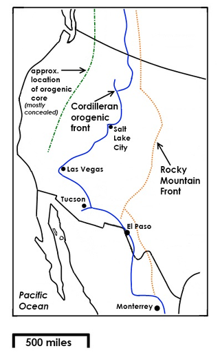
The Rocky Mountain Front is a somewhat unified geologic and ecosystem area in North America where the eastern slopes of the Rocky Mountains meet the plains. In 1983, the Bureau of Land Management called the Rocky Mountain Front "a nationally significant area because of its high wildlife, recreation, and scenic values". Conservationists Gregory Neudecker, Alison Duvall, and James Stutzman have described the Rocky Mountain Front as an area that warrants "the highest of conservation priorities" because it is largely unaltered by development and contains "unparalleled" numbers of wildlife.

<span class="mw-page-title-main">Agriculture in Canada</span> Overview of agriculture in Canada

Canada is one of the largest agricultural producers and exporters in the world. As with other developed nations, the proportion of the population agriculture employed and agricultural GDP as a percentage of the national GDP fell dramatically over the 20th century, but it remains an important element of the Canadian economy. A wide range of agriculture is practised in Canada, from sprawling wheat fields of the prairies to summer produce of the Okanagan valley. In the federal government, overview of Canadian agriculture is the responsibility of the Department of Agriculture and Agri-Food.

<span class="mw-page-title-main">Red Desert (Wyoming)</span> Arid region of south-central Wyoming, United States

The Red Desert is a high-altitude desert and sagebrush steppe located in the south-central portion of the U.S. state of Wyoming, comprising approximately 9,320 square miles. Among the natural features in the Red Desert region are the Great Divide Basin, a unique endorheic drainage basin formed by a division in the Continental Divide, and the Killpecker Sand Dunes, the largest living dune system in the United States. In the 19th century, the Oregon, California, and Mormon Trails crossed the Continental Divide at South Pass, just north of the Red Desert. Today, busy Interstate 80 bisects the desert's southern region while gas field roads cross the desert.

<span class="mw-page-title-main">Pryor Mountain mustang</span> American horse breed

The Pryor Mountain mustang is a substrain of mustang considered to be genetically unique and one of the few strains of horses verified by DNA analysis to be descended from the original Colonial Spanish horses brought to the Americas by the Spanish. They live on the Pryor Mountains Wild Horse Range located in the Pryor Mountains of Montana and Wyoming in the United States, and are the only mustang herd remaining in Montana, and one of sixteen in Wyoming. They are protected by the Wild and Free-Roaming Horses and Burros Act of 1971 (WFRHBA) and managed by the Bureau of Land Management (BLM), who has set the optimum herd number at 120 animals. Genetic studies have revealed that the herd exhibits a high degree of genetic diversity and a low degree of inbreeding, and BLM has acknowledged the genetic uniqueness of the herd. Pryor Mountain Mustangs are relatively small horses, exhibit a natural ambling gait, and domesticated Pryor Mountain mustangs are known for their strength, sure-footedness and stamina. The Pryor Mountains Wild Horse Range is one of the most accessible areas to view feral horse herds in the United States and tourism to the area has increased in recent years.

Agriculture in the Southwest United States is very important economically in that region.

<span class="mw-page-title-main">Vogt–Nunberg Farm</span> United States historic place

The Vogt–Nunberg Farm is a site on the National Register of Historic Places located in Wibaux, Montana. It was added to the Register on April 10, 2008. The application papers state the farm "is an important example of an early twentieth century diversified farming operation in eastern Montana".

Wheat is produced in almost every state in the United States, and is one of the most grown grains in the country. The type and quantity vary between regions. The US is ranked fourth in production volume of wheat, with almost 50 million tons produced in 2020, behind only China, India and Russia. The US is ranked first in crop export volume; almost 50% of its total wheat production is exported.

<span class="mw-page-title-main">Agriculture in Wales</span> Cultivation of plants and animals in Wales

Agriculture in Wales has in the past been a major part of the economy of Wales, a largely rural country that forms part of the United Kingdom. Wales is mountainous and has a mild, wet climate. This results in only a small proportion of the land area being suitable for arable cropping, but grass for the grazing of livestock is present in abundance. As a proportion of the national economy, the importance of agriculture has become much reduced; a high proportion of the population now live in the towns and cities in the south of the country and tourism has become an important form of income in the countryside and on the coast. Arable cropping is limited to the flatter parts and elsewhere dairying and livestock farming predominate.

Agriculture in Alaska faces many challenges, largely due to the climate, the short growing season, and generally poor soils. However, the exceptionally long days of summer enable some vegetables to attain world record sizes.

<span class="mw-page-title-main">Daniel Pond Farmhouse</span> Historic house in Wisconsin, United States

The Daniel Pond Farmhouse, also known as Eggleston Farm, is a limestone-walled home built in Rutland, Wisconsin in the 1840s. In 1980 the house was listed on the National Register of Historic Places.

<span class="mw-page-title-main">Agriculture in Arizona</span>

Agriculture in Arizona is a notable sector in the state’s economy, contributing more than $23.3 billion in 2018. Arizona’s diverse climate allows it to export all sorts of commodities such as nuts, wheat, cotton, eggs, meat, and dairy to the United States and 70 other countries. In 2018, the state produced 455.7 million pounds (206.7 kt) of red meat and ranked 3rd in producing vegetables in the United States, occupying 26 million acres of land for farms and ranches combined.

References

  1. "EPA Region 8 (Mountains and Plains)". US Environmental Protection Agency . Retrieved 2011-12-06.
  2. 1 2 3 4 5 6 Foulke, thomas; Coupal, Taylor (December 2005). "Status of Agricultural Land in Wyoming". Western Regional Science Association.
  3. 1 2 3 "Wyoming Agriculture in the Classroom". Archived from the original on January 2, 2012. Retrieved 6 December 2011.
  4. "Wyoming Geography from NETSTATE" . Retrieved 29 November 2011.
  5. "US Forest Service - Caring for the Land and Serving People". Archived from the original on 8 July 1997. Retrieved 17 November 2011.
  6. O'Gara, Geoffrey (2004). "The Last Open Range". High Country News. 36 (4): 20.
  7. 1 2 3 4 5 Bureau of Land Management, Wyoming (2010). "2010 Annual Report".{{cite journal}}: Cite journal requires |journal= (help)
  8. Bureau of Land Management, Wyoming. "Wild Horse and Burro". Archived from the original on 14 February 2013. Retrieved 6 December 2011.
  9. 1 2 Wyoming Game and Fish Department, Wyoming (2009). "Wyoming Game and Fish Department Strategic Habitat Plan".{{cite journal}}: Cite journal requires |journal= (help)
  10. ThreadEx
  11. "NOWData - NOAA Online Weather Data". National Oceanic and Atmospheric Administration. Retrieved December 10, 2021.
  12. "Station: Cheyenne, WY". U.S. Climate Normals 2020: U.S. Monthly Climate Normals (1991-2020). National Oceanic and Atmospheric Administration. Retrieved December 10, 2021.
  13. "WMO Climate Normals for Cheyenne WSFO, WY 1961–1990". National Oceanic and Atmospheric Administration. Retrieved December 10, 2021.
  14. "U.S. Climate Normals Quick Access". National Oceanic and Atmospheric Administration. Retrieved August 15, 2022.
  15. "NOAA Online Weather Data". National Weather Service. Retrieved August 15, 2022.