
Erie Creek is a creek located in the West Kootenay region of British Columbia. The creek flows into the Salmo River. It was discovered in the 1860s. Erie Creek was originally called North Fork Creek. The creek was mined for gold. [1]

Erie Creek is a creek located in the West Kootenay region of British Columbia. The creek flows into the Salmo River. It was discovered in the 1860s. Erie Creek was originally called North Fork Creek. The creek was mined for gold. [1]
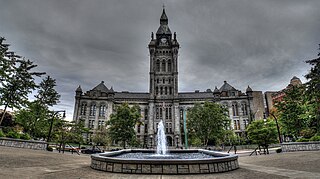
Erie County is a highly populated county located along the shore of Lake Erie in western New York State. As of the 2010 census, the population was 919,040. The county seat is Buffalo, which makes up about 28% of the county's population. Both the county and Lake Erie were named for the regional Iroquoian language-speaking Erie tribe of Native Americans, who lived in the area before 1654. They were later pushed out by the more powerful Iroquoian nations tribes.
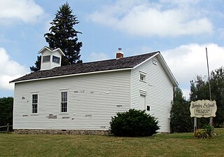
Greenfield Township is a township in Erie County, Pennsylvania, United States. The population was 1,933 at the 2010 census.
The Lynn River is a fresh water river located in Norfolk County in Southwestern Ontario, Canada. It empties into Lake Erie at Port Dover.

The Warren County Canal was a branch of the Miami and Erie Canal in southwestern Ohio about 20 miles (32 km) in length that connected the Warren County seat of Lebanon to the main canal at Middletown in the mid-19th century. Lebanon was at the crossroads of two major roads, the highway from Cincinnati to Columbus and the road from Chillicothe to the College Township (Oxford), but Lebanon businessmen and civic leaders wanted better transportation facilities and successfully lobbied for their own canal, part of the canal fever of the first third of the 19th century. The Warren County Canal was never successful, operating less than a decade before the state abandoned it.

New Denver is at the mouth of Carpenter Creek, on the east shore of Slocan Lake, in the West Kootenay region of southeastern British Columbia. The village is 47 kilometres (29 mi) west of Kaslo on Highway 31A, and 47 kilometres (29 mi) southeast of Nakusp and 32 kilometres (20 mi) northeast of Slocan on Highway 6.
Erie Creek Provincial Park is a provincial park in British Columbia, Canada. It is a protected area because of the wildlife it hosts.
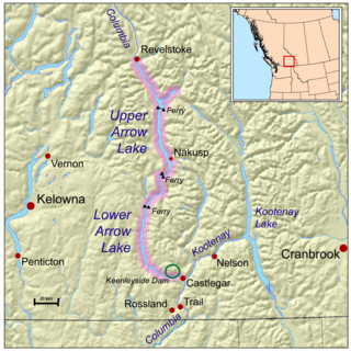
Syringa Park is a provincial park on the east shore of Lower Arrow Lake in the West Kootenay region of southeastern British Columbia. At the foot of the Norns Range, Tulip Creek passes through the centre, and Syringa Creek is closer to the southeastern boundary. The park is about 19 kilometres (12 mi) west of Castlegar via Broadwater Rd.

The Village of Slocan is in the West Kootenay region of southeastern British Columbia. The former steamboat landing and ferry terminal is at the mouth of Springer Creek, at the foot of Slocan Lake. The locality, on BC Highway 6 is about 69 kilometres (43 mi) by road north of Castlegar and 183 kilometres (114 mi) by road and ferry south of Revelstoke.

The Old Erie Canal State Historic Park encompasses a 36-mile (58 km) linear segment of the original Erie Canal's Long Level section. It extends westward from Butternut Creek in the town of DeWitt, just east of Syracuse, to the outskirts of Rome, New York. The park includes restored segments of the canal's waterway and towpath which were in active use between 1825 and 1917. It is part of the New York State Park system.
Lake View is a hamlet in Erie County, New York, United States.

Burton is a settlement on the east shore of Lower Arrow Lake in the West Kootenay region of southeastern British Columbia.
Gold Rush is a reality television series that airs on Discovery and its affiliates worldwide. The series follows the placer gold mining efforts of various family-run mining companies, mostly in the Klondike region of Dawson City, Yukon, Canada. In its 11th season as of early 2020, prior seasons also included mining efforts in South America and western North America.
Jolly Creek is a creek located in the Boundary Country region of British Columbia. The creek is south of Conkle Lake. Jolly Creek flows into Rock Creek. It was discovered in 1860 and has been mined for gold. The Creek was named after local prospector Jolly Jack Thornton.

Quartz Creek is a creek in Selkirk Mountains in the West Kootenay region of the Regional District of Central Kootenay in British Columbia, Canada. This short creek flows into the Salmo River in Ymir, British Columbia. The source of the creek is just to the west of the Ymir townsite a few kilometres up Round Mountain. Quartz creek was mined for gold in the 1860s. The creek is the source of drinking water in the town of Ymir. The Regional District of Central Kootenay added a filtration system in the early 2010s for the community.
Rover Creek is a creek in the West Kootenay Region of British Columbia. The creek is located west of Forty Nine Creek and flows into the Kootenay River. The creek has been mined for gold.
Carpenter Creek is a creek in the West Kootenay region of British Columbia. The creek flows straight through the town of Sandon.
Lemon Creek is an unincorporated community on the east side of the Slocan River in the West Kootenay region of southeastern British Columbia. The locality is on BC Highway 6 about 8 kilometres (5 mi) south of Slocan, and 62 kilometres (39 mi) north of Castlegar.
The San Gabriel Mountains Trailbuilders (SGMTBs) is a 501(c)3 non-profit volunteer organization which performs hiking and nature trail building and maintenance within the Los Angeles Gateway District of the United States Forest Service which maintains the Angeles National Forest within the San Gabriel Mountains.
The Plains of Leon are named for the former gold mining town, Leon once located near the middle of the plain. It is a plain in the Perris Block, contiguous on the south with the Perris Plain including within it the Domenigoni Valley and western Diamond Valley, French Valley, Auld Valley, the upper part of the valley of Warm Springs Creek and connecting tablelands.
Yellowbud is an unincorporated community in Ross County, in the U.S. state of Ohio.
Coordinates: 49°11′25″N117°17′20″W / 49.1903°N 117.289°W