Related Research Articles

Erosion is the action of surface processes that removes soil, rock, or dissolved material from one location on the Earth's crust and then transports it to another location where it is deposited. Erosion is distinct from weathering which involves no movement. Removal of rock or soil as clastic sediment is referred to as physical or mechanical erosion; this contrasts with chemical erosion, where soil or rock material is removed from an area by dissolution. Eroded sediment or solutes may be transported just a few millimetres, or for thousands of kilometres.
Soil erosion is the denudation or wearing away of the upper layer of soil. It is a form of soil degradation. This natural process is caused by the dynamic activity of erosive agents, that is, water, ice (glaciers), snow, air (wind), plants, and animals. In accordance with these agents, erosion is sometimes divided into water erosion, glacial erosion, snow erosion, wind (aeolian) erosion, zoogenic erosion and anthropogenic erosion such as tillage erosion. Soil erosion may be a slow process that continues relatively unnoticed, or it may occur at an alarming rate causing a serious loss of topsoil. The loss of soil from farmland may be reflected in reduced crop production potential, lower surface water quality and damaged drainage networks. Soil erosion could also cause sinkholes.

The Dust Bowl was the result of a period of severe dust storms that greatly damaged the ecology and agriculture of the American and Canadian prairies during the 1930s. The phenomenon was caused by a combination of natural factors and human-made factors: a failure to apply dryland farming methods to prevent wind erosion, most notably the destruction of the natural topsoil by settlers in the region. The drought came in three waves: 1934, 1936, and 1939–1940, but some regions of the High Plains experienced drought conditions for as long as eight years.

A mesa is an isolated, flat-topped elevation, ridge or hill, which is bounded from all sides by steep escarpments and stands distinctly above a surrounding plain. Mesas characteristically consist of flat-lying soft sedimentary rocks capped by a more resistant layer or layers of harder rock, e.g. shales overlain by sandstones. The resistant layer acts as a caprock that forms the flat summit of a mesa. The caprock can consist of either sedimentary rocks such as sandstone and limestone; dissected lava flows; or a deeply eroded duricrust. Unlike plateau, whose usage does not imply horizontal layers of bedrock, e.g. Tibetan Plateau, the term mesa applies exclusively to the landforms built of flat-lying strata. Instead, flat-topped plateaus are specifically known as tablelands.
Natural Resources Conservation Service (NRCS), formerly known as the Soil Conservation Service (SCS), is an agency of the United States Department of Agriculture (USDA) that provides technical assistance to farmers and other private landowners and managers.

A cirque is an amphitheatre-like valley formed by glacial erosion. Alternative names for this landform are corrie and cwm. A cirque may also be a similarly shaped landform arising from fluvial erosion.

Acid erosion is a type of tooth wear. It is defined as the irreversible loss of tooth structure due to chemical dissolution by acids not of bacterial origin. Dental erosion is the most common chronic condition of children ages 5–17, although it is only relatively recently that it has been recognised as a dental health problem. There is widespread ignorance of the damaging effects of acid erosion; this is particularly the case with erosion due to consumption of fruit juices because they tend to be seen as healthy. Acid erosion begins initially in the enamel, causing it to become thin, and can progress into dentin, giving the tooth a dull yellow appearance and leading to dentin hypersensitivity.

A meander is one of a series of regular sinuous curves in the channel of a river or other watercourse. It is produced as a watercourse erodes the sediments of an outer, concave bank and deposits sediments on an inner, convex bank which is typically a point bar. The result of this coupled erosion and sedimentation is the formation of a sinuous course as the channel migrates back and forth across the axis of a floodplain.
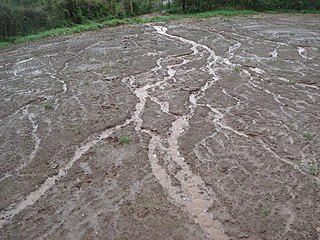
In hillslope geomorphology, a rill is a shallow channel cut into soil by the erosive action of flowing surface water. Similar but smaller incised channels are known as microrills; larger incised channels are known as gullies.

The Conservation Reserve Program (CRP) is a cost-share and rental payment program of the United States Department of Agriculture (USDA). Under the program, the government pays farmers to take certain agriculturally used croplands out of production and convert them to vegetative cover, such as cultivated or native bunchgrasses and grasslands, wildlife and pollinators food and shelter plantings, windbreak and shade trees, filter and buffer strips, grassed waterways, and riparian buffers. The purpose of the program is to reduce land erosion, improve water quality and effect wildlife benefits.
Sodbuster was a program created by Title 12 of the Food Security Act of 1985 designed to discourage the plowing up of erosion-prone grasslands for use as cropland. In congressional hearings for the Agriculture and Food Act of 1981, Idaho governor John Evans urged Congress strongly to enact legislation for sodbuster programs, in combination with a conservation reserve program. Sodbuster measures were already discussed in the 98th United States Congress but were not passed. If such is used for crop production without proper conservation measures as laid out in a conservation plan, a producer may lose eligibility to participate in farm programs. In the 1990 Farm Bill, it was amended and became the super sodbuster, such that producers became ineligible for specified farm program benefits on all their land if they cultivated highly erodible land that was idle. The super sodbuster was repealed by the 1996 Farm Bill.

A riparian buffer or stream buffer is a vegetated area near a stream, usually forested, which helps shade and partially protect the stream from the impact of adjacent land uses. It plays a key role in increasing water quality in associated streams, rivers, and lakes, thus providing environmental benefits. With the decline of many aquatic ecosystems due to agriculture, riparian buffers have become a very common conservation practice aimed at increasing water quality and reducing pollution.
The Universal Soil Loss Equation (USLE) is a widely used mathematical model that describes soil erosion processes.

Inverted relief, inverted topography, or topographic inversion refers to landscape features that have reversed their elevation relative to other features. It most often occurs when low areas of a landscape become filled with lava or sediment that hardens into material that is more resistant to erosion than the material that surrounds it. Differential erosion then removes the less resistant surrounding material, leaving behind the younger resistant material, which may then appear as a ridge where previously there was a valley. Terms such as "inverted valley" or "inverted channel" are used to describe such features. Inverted relief has been observed on the surfaces of other planets as well as on Earth. For example, well-documented inverted topographies have been discovered on Mars.
A converted wetland is one that has been drained, dredged, filled, leveled, or otherwise altered for the production of an agricultural commodity. The definition is part of The Highly Erodible Land Conservation and Wetland Conservation Compliance provisions (Swampbuster) introduced in the 1985 Farm Bill. The provisions aim to reduce soil loss on erosion-prone lands and to protect wetlands for the multiple benefits they provide.
In United States agricultural policy, Highly erodible land (HEL) refers to land that is very susceptible to erosion, including fields that have at least 1/3 or 50 acres (200,000 m2) of soils with a natural erosion potential of at least 8 times their T value. About 101 million acres (410,000 km2) of cropland meet this definition of HEL, according to the 1997 National Resources Inventory. Farms cropping highly erodible land and under production flexibility contracts must be in compliance with a conservation plan that protects this cropland.

The Cheltenham Badlands are in Caledon, Ontario, on the southeast side of Olde Base Line Road, between Creditview and Chinguacousy Roads. The site occupies an area of approximately 0.4 square kilometers and features exposed and highly eroded Queenston shale. The Cheltenham Badlands are a significant educational site due to the readily visible geologic processes and the red colour and the unique topography of the exposed shale make this a popular tourist site. The site is a Provincial Earth Sciences Area of Natural and Scientific Interest (ANSI) since it is considered one of the best examples of "badlands topography" in Ontario.
Erodability is the inherent yielding or nonresistance of soils and rocks to erosion. A high erodibility implies that the same amount of work exerted by the erosion processes leads to a larger removal of material. Because the mechanics behind erosion depend upon the competence and coherence of the material, erodibility is treated in different ways depending on the type of surface that eroded.

Tillage erosion is a form of soil erosion occurring in cultivated fields due to the movement of soil by tillage. There is growing evidence that tillage erosion is a major soil erosion process in agricultural lands, surpassing water and wind erosion in many fields all around the world, especially on sloping and hilly lands A signature spatial pattern of soil erosion shown in many water erosion handbooks and pamphlets, the eroded hilltops, is actually caused by tillage erosion as water erosion mainly causes soil losses in the midslope and lowerslope segments of a slope, not the hilltops. Tillage erosion results in soil degradation, which can lead to significant reduction in crop yield and, therefore, economic losses for the farm.

The Pancake Rocks and Blowholes are a coastal rock formation at Punakaiki on the West Coast of the South Island of New Zealand. They are a popular visitor attraction.
References
![]() This article incorporates public domain material from Jasper Womach. Report for Congress: Agriculture: A Glossary of Terms, Programs, and Laws, 2005 Edition (PDF). Congressional Research Service.
This article incorporates public domain material from Jasper Womach. Report for Congress: Agriculture: A Glossary of Terms, Programs, and Laws, 2005 Edition (PDF). Congressional Research Service.