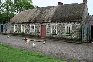
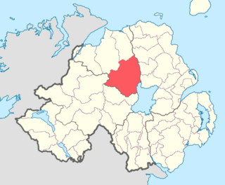
Castlecaulfield is a small village in County Tyrone, Northern Ireland. It lies about 2 miles west of Dungannon and is part of the Mid Ulster District Council area. The village is mostly within the townland of Drumreany, although part of it extends into Lisnamonaghan. It is situated in the historic barony of Dungannon Middle and the civil parish of Donaghmore. It is sometimes called "Caufle" or "Cawfield" by locals. The village came Joint First in the Britain in Bloom in 2016 and first in the Ulster in Bloom in 2015 & 2016.

Ballyrashane is a small village and civil parish outside Coleraine, County Londonderry, Northern Ireland. The civil parish of Ballyrashane covers areas of County Antrim, as well as County Londonderry. It is part of Causeway Coast and Glens district.
Ballyscullion is a small village and civil parish in County Londonderry, Northern Ireland. In the 2001 Census it had a population of 291 people. The civil parish of Ballyscullion covers areas of County Antrim as well as County Londonderry. The village is situated within Mid-Ulster District.

Desertmartin is a small village in County Londonderry, Northern Ireland. It is four miles from Magherafelt, at the foot of Slieve Gallion. In the 2001 Census Desertmartin greater area had a population of 1,276. It had a population of 2257 in 1837 and 3101 in 1910. It lies within Desertmartin parish, Mid-Ulster District, and the historic barony of Loughinsholin. Neighbouring settlements include Draperstown, Magherafelt, Moneymore, and Tobermore.
Straw is a small village and townland in County Londonderry, Northern Ireland. In the 2001 Census it had a population of 57. It is situated within Mid-Ulster District approximately one mile south-west of Draperstown.
Tamlaght is a small village, townland and civil parish in County Londonderry, Northern Ireland. In the 2001 Census it had a population of 123 people. It is situated within Mid-Ulster District. The civil parish of Tamlaght covers areas of County Tyrone as well as County Londonderry.

Clady is a small village and townland in County Tyrone, Northern Ireland. It is about 4 miles from Strabane on the River Finn and borders with the Republic of Ireland. In the 2001 Census it had a population of 423 people. It is within Urney civil parish and the former barony of Strabane Lower. In local government it is part of Derry City and Strabane District Council. The townland covers an area of 173 acres.

Ballylifford is a townland in County Londonderry, Northern Ireland. It is within the civil parish of Ballinderry, on the western shores of Lough Neagh, and is part of Mid-Ulster District. Many of the houses in the area have been built along Ballinderry Bridge Road.
Desertcreat is a parish and a townland in County Tyrone, Northern Ireland. The civil parish of Desertcreat is in the eastern part of County Tyrone in the barony Dungannon Upper, immediately south of the parish of Derryloran, which contains the town of Cookstown, and immediately north of the parish of Pomeroy. The parish has a Church of Ireland Church in the townland of Desertcreat.
Glebe is an area of land within an ecclesiastical parish used to support a parish priest.
Aghalurcher is a civil parish located mainly in the barony of Magherastephana in County Fermanagh and partly in the barony of Clogher in County Tyrone, Northern Ireland.
Aghadowey is a civil and ecclesiastical parish in County Londonderry, Northern Ireland.
Loughinsholin is a barony in County Londonderry, Northern Ireland. Its southeast borders the northwest shore of Lough Neagh, and itself is bordered by seven other baronies: Dungannon Upper to the south; Strabane Upper to the west; Keenaght and Coleraine to the north; Kilconway, Toome Upper, and Toome Lower to the east. It was formed largely on the extent of the medieval Irish túath of Uí Tuirtri.

Drumsamney is a townland lying within the civil parish of Kilcronaghan, County Londonderry, Northern Ireland. It lies in the south-east of the parish on the boundary of the civil parish of Desertmartin, and is bounded by the townlands of; Annagh & Moneysterlin, Ballinderry, Killynumber, Dromore, and Gortamney. In the Plantation of Ulster it was given as a glebe to the Drapers Company.
Craigadick is a townland lying within the civil parish of Maghera, County Londonderry, Northern Ireland. It lies in the west of the parish sharing a small boundary with Killelagh civil parish. It is bounded by the townlands of; Ballynahone Beg, Craigmore, Falgortrevy, Largantogher, Moneymore, Mullagh, Tamnymullan, and Tullyheran. It wasn't apportioned to any of the London livery companies, being kept as church lands.

Magheracross is a townland and civil parish in County Fermanagh, Northern Ireland. It extends in area from just north of Enniskillen to the Border with County Tyrone. There is also a small enclave in County Tyrone.
Finvoy is a hamlet and civil parish in County Antrim, Northern Ireland. It is situated in the historic barony of Kilconway. The hamlet had a population of 187 people in the 2011 Census.
Cloncurkney is a townland in the civil parish of Templeport, County Cavan, Ireland. It lies in the Roman Catholic parish of Templeport and barony of Tullyhaw.