Ankara, historically known as Ancyra and Angora, is the capital of Turkey. Located in the central part of Anatolia, the city has a population of 5.1 million in its urban center and 5.7 million in Ankara Province, making it Turkey's second-largest city after Istanbul, but first by the urban area.

Çankaya is a municipality and district of Ankara Province, Turkey. Its area is 483 km2, and its population is 942,553 (2022). It is home to many government buildings, including the Grand National Assembly of Turkey, as well as nearly all foreign embassies to Turkey. Çankaya is a cosmopolitan district and considered the cultural and financial center of Ankara.

Altındağ is a municipality and district of Ankara Province, Turkey. Its area is 123 km2, and its population is 413,994 (2022). It covers the northeastern part of the city of Ankara. Its elevation is 900 m (2,953 ft).

Çamlıdere is a municipality and district of Ankara Province, Turkey. Its area is 782 km2, and its population is 8,100 (2022). It is 108 km north-west of the city of Ankara. Its elevation is 1,240 m (4,068 ft).

Çubuk is a municipality and district of Ankara Province, Turkey. Its area is 1,198 km2, and its population is 95,449 (2022). Çubuk is in a flat plain 35 km north of the city of Ankara, where Ankara airport is located. Its elevation is 1,000 m (3,281 ft).

Etimesgut, formerly Ahimesut, is a municipality and metropolitan district of Ankara Province, Turkey. Its area is 273 km2, and its population is 614,891 (2022). It mainly consists of large public housing projects, 25 km (16 mi) from Ankara city centre. Its elevation is 843 m (2,766 ft).
Evren, formerly Çıkınağıl, is a municipality and district of Ankara Province, Turkey. Its area is 369 km2, and its population is 40,625 (2022). It is 178 km from the city of Ankara. Its elevation is 887 m.

Güdül is a municipality and district of Ankara Province, Turkey. Its area is 540 km2, and its population is 8,079 (2022). It is 90 km north-west of the city of Ankara, off the motorway to Istanbul.

Güzelkent is a neighbourhood in the municipality and district of Akyurt, Ankara Province, Turkey. Its population is 15,384 (2022). It is located near the Eryaman neighbourhood, 25 km far from the city centre of Ankara, and is bordered by Eryaman, Sincan, Fatih and Etimesgut.

Bala, formerly known as Balbadon, is a municipality and district of Ankara Province, Turkey. Its area is 1,851 km2, and its population is 20,521 (2022). It is 67 km south-east of the city of Ankara. Its elevation is 1,310 m (4,298 ft).

Kahramankazan is a municipality and district of Ankara Province, Turkey. Its area is 547 km2, and its population is 59,123 (2022). It lies in the plain of Akıncı to the north west of the city of Ankara. Its elevation is 892 m (2,927 ft).

Beypazarı is a municipality and district of Ankara Province, Turkey. Its area is 1,697 km2, and its population is 48,357 (2022). It is approximately 100 km west of the city of Ankara. The elevation in the center is 675 m (2,215 ft). It used to be an important city in Asia Minor in ancient times.
Ankara Güvercinlik Army Air Base, is a military airport of the Turkish Army located in Güvercinlik of Etimesgut district, 10 km (6.2 mi) west of Ankara in central Turkey.

Pursaklar is a municipality and metropolitan district of Ankara Province, Turkey. Its area is 169 km2, and its population is 162,389 (2022). It became a town municipality within the district of Keçiören in 1986. In 2008 it became a district, and the former municipalities of Sarayköy, Sirkeli and Altınova (partly) were added to it. There are 19 neighborhoods under its administration.

Kepez is a municipality and district of Antalya Province, Turkey. Its area is 292 km2, and its population is 608,675 (2022).
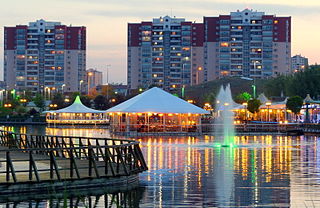
Göksu Park is a public park in Ankara, Turkey. Göksu Park is in Eryaman, a neighbourhood in the district of Etimesgut in Ankara. The park area is 50.8 ha. It was an unneglected lake until 2003. In 2003, the lake was taken care of by the Municipality of Ankara and Municipality of Etimesgut and the park was opened that same year.

The Eryaman Stadium is a stadium in the Eryaman neighbourhood of Etimesgut, Ankara, Turkey. The construction began in 2016 and was completed in 2019. Gençlerbirliği and Ankaragücü use the stadium for home games.
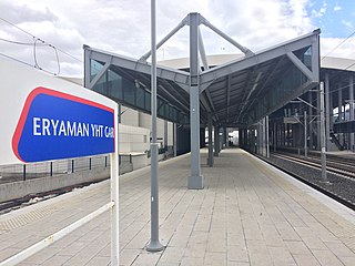
Eryaman YHT railway station, previously known as Ankara West YHT railway station, is a railway station in Ankara, Turkey. Once Başkentray commuter rail service begins in April, the station will become a transfer point between YHT high-speed trains and local commuter trains, replacing Sincan station. Eryaman station also replaced Emirler station, located about 175 m (574 ft) east of the station, which was demolished in July 2016.
Ata is a neighbourhood in the municipality and district of Yenimahalle, Ankara Province, Turkey. Its population is 28,886 (2022).