
La Manga, or La Manga del Mar Menor is a seaside spit of Mar Menor in the Region of Murcia, Spain.

Mar Menor is a coastal saltwater lagoon in the Iberian Peninsula located south-east of the Autonomous Community of Murcia, Spain, near Cartagena. Its name is the opposite of the Mediterranean, which is the Mar Mayor of the region.

Torre-Pacheco is a municipality in the autonomous community of Murcia in southeastern Spain. It covers an area of 189.4 km2 and its population in 2019 was 35,676. The only high ground in the municipality is Cabezo Gordo hill, the location of the protected Sima de las Palomas archeological site. The town has one secondary education institution, the I.E.S. Gerardo Molina.

The Region of Murcia is an autonomous community of Spain located in the southeastern part of the Iberian Peninsula, on the Mediterranean coast. The region is 11,313 km2 (4,368 sq mi) in area and had a population of 1,511,251 as at the start of 2020. About a third of its population lives in the capital, Murcia, and a seventh in the second city, Cartagena. At 2,014 m (6,608 ft), the region's highest point is Los Obispos Peak in the Massif of Revolcadores.
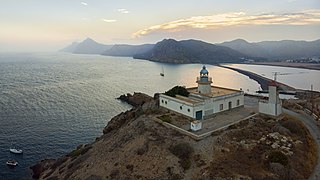
Cape Palos is a cape in the Spanish municipality of Cartagena, in the region of Murcia. It is part of a small range of volcanic mounts that form a small peninsula. The Mediterranean islands of Grosa and the group known as the Hormigas Islands are part of this range, as well as the islands in the Mar Menor. The name Palos is derived from the Latin word palus, meaning ‘lagoon’, a reference to the Mar Menor.
El Puente de la Pólvora was a metallic bridge with stone abutments spanning the Segura River. The structure was completed with five stone arches on the left side of the bridge designed to span the river flood plain. Built between 1870 and 1877 in the vicinity of Javalí Viejo and Alcantarilla, in the Región de Murcia (Spain), the bridge was designed by the civil engineers Manuel Pardo Sánchez-Salvador and José Caunedo Sánchez. Both structures were built by Pedro Díaz Sánchez y Francisco Peña y Baquero respectively.

Campo de Cartagena is a natural region (comarca) located in the Region of Murcia, in Spain. For administrative purposes, it is also known as Comarca del Campo de Cartagena or Comarca de Cartagena. It is located in the southeast of the Iberian Peninsula, forming a plain which extends from the Sierra de Carrascoy to the Mediterranean. The capital city is Cartagena, the most important Naval Base of the Spanish Navy in the Mediterranean Sea.

The Cathedral of Cartagena in Spain, or the Cathedral of Santa María la Vieja, was a cathedral of the Diocese of Cartagena, located on the hill of La Concepción in the old town of Cartagena. It has been in ruins since 1939, when it was destroyed when Cartagena was shelled in the Spanish Civil War by Nationalist forces.
Los Nietos, Spain is a small fishing village with its own individual marina on the Mar Menor, which began as a very small fishing settlement and was later urbanised to allow more holiday homes by the Mar Menor. It is now a busy community with many visitors, especially in the summer, with some events at other times. Many foreigners, mainly British, live there. The village is at the eastern terminus of the Cartagena–Los Nietos commuter railway line.

The Punic wall of Cartagena is an archaeological site from the 3rd century BC in which can be seen the first defensive wall of Cartagena, built by the Carthaginians.

Cartagena is a Spanish city and a major naval station on the Mediterranean coast, south-eastern Iberia. As of January 2018, it has a population of 218,943 inhabitants. This makes Cartagena Murcia's second-largest municipality and Spain's sixth-largest city that is not a provincial-capital. The wider urban or metropolitan area of Cartagena, known as Campo de Cartagena, has a population of 409,586 inhabitants.

The Regional Assembly of Murcia is the autonomous parliament of the Region of Murcia, one of the autonomous communities of Spain. The unicameral assembly, which contained 45 elected legislative seats, is located in the Murcian city of Cartagena, Spain.

Anthemis chrysantha is an Ibero-North African annual asteraceae endemism present in a few Cartagenan and Algerian islets and coastal locations.
The following is a timeline of the history of the city of Cartagena, Spain.

The Spanish municipality of Cartagena has 24 districts, known as diputaciones (councils). The original 17 districts established at the beginning of the 18th century were maintained throughout that century, and were the equivalent of the pedanías in other areas. This administrative structure was put in place in response to population increase in that era, and because the municipality was becoming less tractable.

The port of Cartagena is the port located in Cartagena, Spain. It is the fourth nationwide port in freight traffic behind Algeciras, Valencia and Barcelona. It occupies the eighth place in relation to the number of cruises. 60% of exports and the 80% of imports from the Region of Murcia are made through the port of Cartagena. More than 40% of the tourism that Cartagena receives is made by its port.

The National Museum of Subaquatic Archaeology is a underwater archaeology museum in Cartagena (Murcia), Spain. It owns a large collection of pieces recovered from shipwrecks that begins in the Phoenician period, and arrives until the 19th century. It is one of the National Museums of Spain and it is attached to the Ministry of Culture.
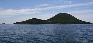
Isla Grosa is an island in the Mediterranean Sea, belonging to the municipality of San Javier in the Region of Murcia, at a distance of 2.5 km from the northern part of La Manga del Mar Menor. It has an area of 17.5 hectares and is over 90 m high.

The Sierra de la Fausilla natural area is located in the south of the Region of Murcia, in the municipality of Cartagena, to the east of the city in the area surrounding the Bay of Escombreras. It has a surface area of 791 ha.
Portmán is a locality in the Region of Murcia, Spain, located to the south of the municipality of La Unión at the foot of the mining mountain range of Cartagena-La Unión in a bay bathed by the Mediterranean Sea.
