Related Research Articles

The Tla-o-qui-aht First Nations are a Nuu-chah-nulth First Nation in Canada. They live on ten reserves along the Pacific Rim National Park Reserve on Vancouver Island, British Columbia. The band is part of the Nuu-chah-nulth Tribal Council. There were 618 people living in the Tla-o-qui-aht reserves in 1995. Their primary economic activities are fishing and tourism.
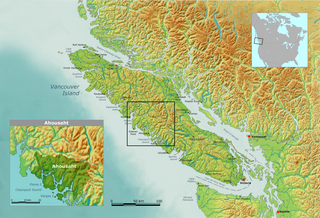
Nuu-chah-nulth, a.k.a.Nootka, is a Wakashan language in the Pacific Northwest of North America on the west coast of Vancouver Island, from Barkley Sound to Quatsino Sound in British Columbia by the Nuu-chah-nulth peoples. Nuu-chah-nulth is a Southern Wakashan language related to Nitinaht and Makah.

Hesquiat Peninsula Provincial Park is a provincial park at the western extremity of the Clayoquot Sound region of the West Coast of Vancouver Island, British Columbia, Canada. The park was established by order-in-council on July 12, 1995 as part of the Clayoquot Land-Use Decision.
The Mowachaht/Muchalaht First Nations are a First Nations government on the west coast of Vancouver Island in the Canadian province of British Columbia. The Mowachaht/Muchalaht First Nations are a member nation of the Nuu-chah-nulth Tribal Council, which spans all Nuu-chah-nulth-aht peoples except for the Pacheedaht First Nation.

Tseshaht First Nation is an amalgamation of many tribes up and down Alberni Inlet and in the Alberni Valley of central Vancouver Island in the Canadian province of British Columbia. They are a member of the Nuu-chah-nulth Tribal Council which includes all other Nuu-chah-nulth-aht peoples except the Pacheedaht First Nation.
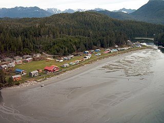
Ahousaht, also spelled Ahousat, is the principal settlement on Flores Island, in British Columbia, Canada. Accessible only by water or air, Ahousaht is a small community predominantly composed of First Nations people from the Nuu-chah-nulth nation. The settlement is named for the Ahousaht subgroup of the Nuu-chah-nulth, whose modern Indian Act government is the Ahousaht First Nation which combines the Ahousaht, Manhousaht and Keltsmaht under one administration. The other main settlement of the Ahousaht First Nation is at Marktosis.
The Upper Similkameen Indian Band or Upper Smelqmix, is a First Nations band government in the Canadian province of British Columbia, whose head offices are located in town of Hedley in the Similkameen Country. They are a member of the Okanagan Nation Alliance.
The Nuu-chah-nulth Tribal Council is a First Nations Tribal Council in the Canadian province of British Columbia, located on the west coast of Vancouver Island. The organization is based in Port Alberni, British Columbia.
The Kyuquot/Cheklesath First Nation or First Nations is a modern treaty government located on the west coast of Vancouver Island in British Columbia, Canada. It is a member of the Maa-nulth Treaty Society and the Nuu-chah-nulth Tribal Council.

The Ehattesaht First Nation is a First Nations government covering about 660 km^2 on the West Coast of Vancouver Island in the British Columbia, Canada. It is a band that is one of the 14 Nuu-Chah-Nuulth Nations and is now a member of the Nuu-chah-nulth Tribal Council. In the modern-day, there are currently only 539 registered members as of October 2021. with a language that has been lost over the years as the British Columbia government states that there are only 52 speakers of the language.

The Bonaparte Indian Band a.k.a. Bonaparte First Nation, is a member band of the Shuswap Nation Tribal Council of the Secwepemc (Shuswap) people.
The Esk'etemc First Nation, also known as the Alkali Lake Indian Band, is a First Nations government of the Secwepemc (Shuswap) people, located at Alkali Lake in the Cariboo region of the Central Interior of the Canadian province of British Columbia. It was created when the government of the then-Colony of British Columbia established an Indian reserve system in the 1860s. It is one of three Secwepemc bands that is not a member of either the Shuswap Nation Tribal Council or the Northern Shuswap Tribal Council.
Opitsaht, spelled also as Opitsat and Opitsitah, is a Tla-o-qui-aht settlement/community in the Southwest area of the Meares Islands, Clayoquot South, British Columbia. This peninsula-like region is the home to the Tla-o-qui-aht people from the Nuu-chah-nulth nation, a tribe from the Pacific Northwest region in the lower Vancouver area, known for their lifestyle revolving around the marine life trade and culture within the community.
Marktosis, also spelled Maaqtusiis in the Nuu-chah-nulth language, is one of the principal settlements of the Ahousaht First Nation, located off the west coast of Vancouver Island in British Columbia, Canada, just southeast of the Hesquiat Peninsula on Flores Island. Accessible only by water or air, Marktosis is a small community predominantly composed of First Nations people from the Nuu-chah-nulth nation. Marktosis has approximately 900 residents. Marktosis Indian Reserve No. 15 was established around the site of the community and has 622 individuals living on the reserve in 2016.
Hiellen 2, properly known as Hiellen Indian Reserve No. 2, is an Indian reserve on the north coast of Graham Island in the Queen Charlotte Islands, British Columbia, Canada. It is located at the mouth of the Hiellen River and is the site of the former Haida village of Hiellen, once one of the largest and most important. The reserve is under the administration of the Old Massett Village Council and is 27.4 ha in size.
The Douglas First Nation, aka the Douglas Indian Band, Douglas Band, or Xa'xtsa First Nation, are a band government of the In-SHUCK-ch Nation, a subgroup of the larger St'at'imc people, also referred to as Lower Stl'atl'imx. The Douglas, Skatin and Samahquam communities are related through familial ties as well as culturally and linguistically. The In-SHUCK-ch are the southernmost of the four divisions making up the Lillooet ethnographic group. The Douglas First Nation's main community is at Xa'xtsa, a village on their main reserve at the head of Harrison Lake, near the former gold rush port-town of Port Douglas.
Ki-Ke-In, also known as Chuuchkamalthnii, Haa'yuups, and Ron Hamilton is a Nuu-chah-nulth cultural figure from the Hupacasath First Nation. His work includes sculpture, drawings, paintings, dance, song, writing, regalia and curatorial activities which document the ceremonial life of his people. A resident of Port Alberni, Ki-ke-in's exhibition of his own and historical Nuu-chah-nulth ceremonial curtains at the University of British Columbia formed part of the 2010 Vancouver Cultural Olympiad. A fisherman by trade, the resources he works with are Campbell River slate, wood, silver, gold, and ivory, often modelling his work on the sea serpent.
The Esowista Peninsula is a peninsula in the Clayoquot Sound region of the west coast of Vancouver Island, British Columbia, Canada. The name was adopted in 1934 in reference to Esowista Indian Reserve No. 3. The name originally applied to the neck of land between Templar Channel and Browning Passage, centred at 49°08′N125°54′W to the whole neck of land from Grice Bay, Long Beach and Tofino. It was originally charted as Low Peninsula by the Royal Navy in 1860. Much of the peninsula is within the Pacific Rim National Park Reserve.

Tim Paul is a member of the Hesquiaht tribe from the Nuu-Chah-Nulth first nation. He is a master carver from Esperanza Inlet British Columbia. He was the senior carver at the Royal British Columbia Museum until 1992 when he left to oversee an indigenous education program for the Port Alberni school board on Vancouver Island.
Samuel Haiyupis is a Nuu-chah-nulth artist from Ahousaht, British Columbia. The Canadian Museum of History has one of his carvings on display in its Grand Hall.
References
- ↑ BC Names entry "Esowista Peninsula"
- ↑ BC Names entry "Esowista 3 (Indian reserve)"
- ↑ "Indian and Northern Affairs Canada, "Reserves/Settlements/Villages Detail"". Crown–Indigenous Relations and Northern Affairs Canada . Government of Canada. Retrieved 2013-07-23.
- ↑ Source: Ha-shilth-sa newspaper, 2003. All translations were compiled with consultation from Nuuchahnulth elders. Ha-shilth-sa (meaning 'interesting news') is the official newspaper for the Nuu-chah-nulth nation.
49°04′00″N125°47′00″W / 49.06667°N 125.78333°W
| | This article about an Indian reserve in British Columbia is a stub. You can help Wikipedia by expanding it. |