The Tla-o-qui-aht First Nations are a Nuu-chah-nulth First Nation in Canada. They live on ten reserves along the Pacific Rim National Park Reserve on Vancouver Island, British Columbia. The band is part of the Nuu-chah-nulth Tribal Council. There were 618 people living in the Tla-o-qui-aht reserves in 1995. Their primary economic activities are fishing and tourism.

Nootka Island is an island adjacent to Vancouver Island in British Columbia, Canada. It is 534 square kilometres (206 sq mi) in area. It is separated from Vancouver Island by Nootka Sound and its side-inlets, and is located within Electoral Area A of the Strathcona Regional District.
Hesquiat Peninsula Provincial Park is a provincial park at the western extremity of the Clayoquot Sound region of the West Coast of Vancouver Island, British Columbia, Canada. The Hesquiat Peninsula forms the division between the Clayoquot Sound region, to the south, and the Nootka Sound region to the north. The park contains 7,898 ha. and was created as part of the Clayoquot Land-Use Decision. The peninsula is named for the Hesquiaht group of the Nuu-chah-nulth peoples. Hesquiat Indian Reserve No. 1 and adjoining locality and former steamer landing of Hesquiat are located on its southeastern tip. Estevan Point, a lighthouse that was the setting for one of the few Japanese military attacks on North America in World War II, is on the southwestern tip.

Yuquot, also known as Fort San Miguel or Friendly Cove, is a small settlement of around six people - The Williams family of the Mowachaht band, plus two full-time lighthouse keepers, located on Nootka Island in Nootka Sound, just west of Vancouver Island, British Columbia, Canada. It was the summer home of Chief Maquinna and the Mowachaht/Muchalaht (Nuu-chah-nulth) people for generations, housing approximately 1,500 natives in 20 traditional wooden longhouses. The name means "Wind comes from all directions" in Nuu-chah-nulth.

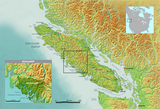
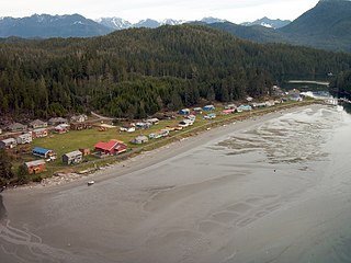
Ahousaht, also spelled Ahousat, is the principal settlement on Flores Island, in British Columbia, Canada. Accessible only by water or air, Ahousaht is a small community predominantly composed of First Nations people from the Nuu-chah-nulth nation. The settlement is named for the Ahousaht subgroup of the Nuu-chah-nulth, whose modern Indian Act government is the Ahousaht First Nation which combines the Ahousaht, Manhousaht and Keltsmaht under one administration. The other main settlement of the Ahousaht First Nation is at Marktosis.
The Nuu-chah-nulth Tribal Council is a First Nations Tribal Council in the Canadian province of British Columbia, located on the west coast of Vancouver Island. The organization is based in Port Alberni, British Columbia.

The Ahousaht First Nation is a First Nation government based on the west coast of Vancouver Island in British Columbia, Canada, focused on the community of Ahousaht, British Columbia. It is a member of the Nuu-chah-nulth Tribal Council. It is led by Chief, A-in-chut Shawn Atleo and the Tyee Haw'iilth - Maquinna.

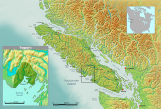
The Toquaht Nation is a First Nations government based on the west coast of Vancouver Island in British Columbia, Canada. It is a member of the Nuu-chah-nulth Tribal Council.
Kyuquot Sound is a complex of coastal inlets, bays and islands on northwestern Vancouver Island in the Canadian province of British Columbia.

Meares Island is one of the many islands surrounding the Village of Tofino, British Columbia, Canada. Its name was given in 1862 by George Henry Richards, captain of HMS Hecate, in honor of John Meares. The island is located in the Clayoquot Sound region and is the location of Opitsat, the main village of the Tla-o-qui-aht First Nations, and was the location of Fort Defiance, a short-lived American fur-trading post founded by Captain Robert Gray.

Opitsaht, spelled also as Opitsat and Opitsitah, is a community of the Tla-o-qui-aht people of the Nuu-chah-nulth nation, located at the SW end of Meares Island in Clayoquot Sound. During the era of the Maritime Fur Trade, Opitsaht was the seat of Wickaninnish, chief of the Tla-o-qui-aht, and contained 200 ornately carved buildings typical of Nuu-chah-nulth villages. This original village was destroyed by cannon fire by Captain Robert Gray of the Columbia Rediviva as part of a falling-out with the Tla-o-qui-aht when Gray evacuated his erstwhile "fort" nearby on Meares Island, known as Fort Defiance. Today Opitsaht is one of the main villages governed by the Tla-o-qui-aht First Nations, the band government of the Tla-o-qui-aht people.

Marktosis, also spelled Maaqtusiis in the Nuu-chah-nulth language, is one of the principal settlements of the Ahousaht First Nation, located off the west coast of Vancouver Island in British Columbia, Canada, just southeast of the Hesquiat Peninsula on Flores Island. Accessible only by water or air, Marktosis is a small community predominantly composed of First Nations people from the Nuu-chah-nulth nation. Marktosis has approximately 900 residents. Marktosis Indian Reserve No. 15 was established around the site of the community and has 622 individuals living on the reserve in 2016.
Kiix-in, or Kiix?in , earlier romanized as Keeshan, was the principal residence of the Huu-ay-aht (Ohiaht) group of the Nuu-chah-nulth people. The name is onomatopoeic, and comes from the sound of waves crashing against the rocks below the village. It was initially romanised as "Keeshan", but was redesignated "Kiix-in " in line with the Maa-nulth Treaty.
The Bedwell River is a river in the Clayoquot Sound region of the West Coast of Vancouver Island, British Columbia, Canada, emptying into Bedwell Sound, which lies to the north of Meares Island, near the tourist town of Tofino. The indigenous name in the Nuu-chah-nulth language is Oinimitis, which is the namesake of the Oinimitis Trail. Oinimitis Indian Reserve No. 4 is located at the mouth of the river. The river was originally designated the Bear River by Captain Richards, but was renamed in 1923 in relation to Bedwell Sound. Locals still call it the Bear River. The You Creek branch of the Bedwell, or Bear, River was first explored by pioneer Joe Drinkwater.
Bedwell Sound is a sound on the West Coast of Vancouver Island, British Columbia, Canada. It is located in the Clayoquot Sound region to the north of Meares Island and the resort community of Tofino. The Bedwell River, originally the Bear River and called Oinimitis in the Nuu-chah-nulth language, empties into and gets its current name from the Sound.
Esowista Indian Reserve No. 3, also known as Esowista 3, is an Indian reserve located on the Esowista Peninsula in the Clayoquot Sound region of the west coast of Vancouver Island, British Columbia, Canada. Located at the head of Wickaninnish Bay, just east of Schooner Cove, it is part of the group of reserves under the governance of the Tla-o-qui-aht First Nations of the Nuu-chah-nulth peoples. Its population in 2006 was 160.
The Hesquiat Peninsula is a peninsula on the West Coast of Vancouver Island, British Columbia, located northwest of the town of Tofino and Clayoquot Sound and Nootka Sound to the northwest. It marks the division between the two regions formed by those sounds and is named for the Hesquiaht people of the Nuu-chah-nulth, and is the location of Hesquiat Peninsula Provincial Park. The Estevan Point lighthouse is at the apex of the peninsula.`
Clayoquot Sound Biosphere Reserve is a UNESCO Biosphere Reserve situated in Vancouver Island on the west coast of British Columbia. A diverse range of ecosystems exist within the biosphere reserve boundaries, including temperate coastal rainforest, ocean and rocky coastal shores.


