Related Research Articles
Catala Island Marine Provincial Park is a provincial park in British Columbia, Canada, located on the west coast of Vancouver Island at the mouth of Esperanza Inlet, between Kyuquot Sound (N) and Nootka Sound (S). The park is 955 ha. in size and was established in July 1995.
Háthayim Marine Provincial Park, formerly Von Donop Marine Provincial Park, is a provincial park in British Columbia, Canada, located on the north end of Cortes Island in the Discovery Islands.
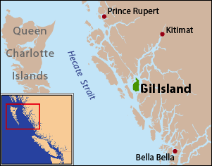
Gil Island is an island on the North Coast of British Columbia, Canada, located on the west side of Whale Channel in the entrance to Douglas Channel, one of the main coastal inlets, on the route of the Inside Passage between Pitt Island and Princess Royal Island. It is 26 km long, with a width ranging from 6 to 13 km, and an area of 231 km2. The only named summit on the mountainous island is Mount Gil, which faces the opening of Douglas Channel.
Meares Island is one of the many islands surrounding the Village of Tofino, British Columbia, Canada. Its name was given in 1862 by George Henry Richards, captain of HMS Hecate, in honor of John Meares. The island is located in the Clayoquot Sound region and is the location of Opitsat, the main village of the Tla-o-qui-aht First Nations, and was the location of Fort Defiance, a short-lived American fur-trading post founded by Captain Robert Gray.
Denny Island is an island on the Central Coast of British Columbia, Canada, just east of the community of Bella Bella, aka Waglisla, on Campbell Island. Denny Island is the location of Old Bella Bella, now mainly abandoned but home to Canadian Coast Guard and Fisheries & Oceans bases, and the locality of Shearwater, home to Shearwater Marine. Denny Island has a population of 138. Denny Island's shining glory is the McEmery Aquatic Centre located on Reservoir Lane.
Gribbell Island is an island on the North Coast of British Columbia, Canada, located on the east side of the entrance to Douglas Channel at Wright Sound. Gribble Island Indian Reserve No. 10 is on its west coast, between Verney Passage and Ursula Channel at 53°21′00″N129°08′00″W. The small Wimbledon Range is on the south side of the island, facing the northern extremities of Princess Royal Island to the south, at 53°21′00″N129°02′00″W
The Defence Islands are two small islands in Howe Sound, British Columbia, Canada, located northeast of Anvil Island and in the northern reaches of that sound near Porteau Cove. The easterly and smaller of the two comprises Defence Island Indian Reserve No. 28, 1.7 ha., the westerly comprises the Kwum Kwum Indian Reserve (unnumbered), 6.20 ha. Both are under the administration of the Squamish Nation.
Bramham Island is an island in the Queen Charlotte Strait region of the Central Coast of British Columbia, Canada, located on the north side of the entrance to that strait. It lies in the entrance to the maze of waterways inland to the northeast, focussed on Seymour Inlet, which includes Belize Inlet and Allison Harbour and Nugent Sound, though it is flanked only by Slingsby Channel, on its north, and by Schooner Channel on its east. To its west are the open waters at the convergence of Queen Charlotte Sound and Queen Charlotte Strait. The island is approximately 23 km2 in size and is mostly low-lying hills and includes a number of freshwater lakes.

The Courtenay River is a short river on Vancouver Island, British Columbia, Canada, being the name of the channel from the confluence of the Puntledge and Tsolum Rivers, in the City of Courtenay, and its outlet into Comox Harbour, which is a part of the Strait of Georgia.
De Horsey Island is an island at the mouth of the Skeena River in the North Coast region of British Columbia, Canada, located immediately south of the southern tip of the Tsimpsean Peninsula and immediately east of Smith Island. Separating it from that island is De Horsey Passage, while to its north separating it from the Tsimpsean Peninsula is Eleanor Passage. Kshaoom Indian Reserve No. 23 is on its northwest tip.
De Horsey Passage is a short strait in the North Coast of British Columbia, Canada, separating De Horsey Island to the east from Smith Island to the west. The passage, like the island, was named for Rear Admiral Algernon Frederick Rous de Horsey, commander in chief on this station from 1876 to 1879. His flagship was HMS Shah, 26 guns, under Captain Bedford.
The Pearse Islands are a small group of islands in the Queen Charlotte Strait region of the Central Coast of British Columbia, Canada. They are just east of Cormorant Island, which is the location of the Village of Alert Bay. Cormorant Channel Marine Provincial Park is located in this group of islands.
Beaver Harbour is a harbour or bay on northern Vancouver Island, British Columbia, Canada, located to the east of the town of Port Hardy. Beaver Harbour Provincial Park was located on the west side of the bay but was transferred to local governance in 1970.
Kingcome Point is a headland on the northwest tip of Princess Royal Island in the North Coast region of British Columbia, Canada.
The Wakeman River is a river in the western Pacific Ranges on the Central Coast region of British Columbia, Canada, flowing south into Wakeman Sound, which is a sidewater of Kingcome Inlet.
Eliot Passage is a marine waterway between Village Island (E) and Pearl Island (W) in the Johnstone Strait region of the Central Coast of British Columbia, Canada, southwest of the opening of Knight Inlet. The Kwakwaka'wakw village of Memkumlis, also known as Mamalillaculla after the name of the group of Kwakwaka'wakw whose principal village it is, is on its eastern shore on Village Island.
Farewell Harbour is a harbour and landing in the area of Johnstone Strait of the Central Coast region of British Columbia, Canada, located between Swanson, Crease and Harbledown Islands.
Compton Island is an island in the Queen Charlotte Strait-Johnstone Strait region of the Central Coast of British Columbia, Canada, located in Blackfish Sound to the east of Port McNeill All of Compton Island and three small islands offshore comprise Compton Island Indian Reserve No. 6, a.k.a. Compton 6.
Compton Point is a headland in the Queen Charlotte Strait region of the Central Coast of British Columbia, Canada, forming the northwest entrance point to Wells Passage opposite North Broughton Island.
Waddington Harbour is a harbour at the head of Bute Inlet in the Central Coast region of British Columbia, Canada. Also issuing into the head of Bute Inlet and Waddington Harbour, just east of the mouth of the Homathko, is the Teaquahan River. Issuing directly into the inlet a few miles south on the harbour's southeast is the Southgate River, one of the major rivers of the central Pacific Ranges, which begins on the west side of the Lillooet Icecap. Its lower valley adjacent to the inlet's shores is called Pigeon Valley.
References
- ↑ adapted from John T. Walbran, British Columbia Coast Names, 1592-1906: their origin and history, publ Ottawa 1909 as quoted in BC Names entry "Templar Channel"
- ↑ Victoria Colonist, 14 December 1860 and 24 January 1862
- ↑ adapted from John T. Walbran, British Columbia Coast Names, 1592-1906: their origin and history, publ Ottawa 1909 as quoted in BC Names entry "Templar Channel"
Coordinates: 49°07′50″N125°55′11″W / 49.13056°N 125.91972°W