Espenberg River

Last updated

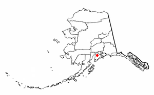
The Espenberg River[ pronunciation? ] is a 21-mile-long (34 km) river in Alaska's North Slope flowing northeast into the Chukei Seas. [1]

River Natural flowing watercourse

A river is a natural flowing watercourse, usually freshwater, flowing towards an ocean, sea, lake or another river. In some cases a river flows into the ground and becomes dry at the end of its course without reaching another body of water. Small rivers can be referred to using names such as stream, creek, brook, rivulet, and rill. There are no official definitions for the generic term river as applied to geographic features, although in some countries or communities a stream is defined by its size. Many names for small rivers are specific to geographic location; examples are "run" in some parts of the United States, "burn" in Scotland and northeast England, and "beck" in northern England. Sometimes a river is defined as being larger than a creek, but not always: the language is vague.

Alaska State of the United States of America

Alaska is a U.S. state in the northwest extremity of North America, just across the Bering Strait from Asia. The Canadian province of British Columbia and territory of Yukon border the state to the east and southeast. Its most extreme western part is Attu Island, and it has a maritime border with Russia to the west across the Bering Strait. To the north are the Chukchi and Beaufort seas—southern parts of the Arctic Ocean. The Pacific Ocean lies to the south and southwest. It is the largest U.S. state by area and the seventh largest subnational division in the world. In addition, it is the 3rd least populous and the most sparsely populated of the 50 United States; nevertheless, it is by far the most populous territory located mostly north of the 60th parallel in North America: its population—estimated at 738,432 by the United States Census Bureau in 2015— is more than quadruple the combined populations of Northern Canada and Greenland. Approximately half of Alaska's residents live within the Anchorage metropolitan area. Alaska's economy is dominated by the fishing, natural gas, and oil industries, resources which it has in abundance. Military bases and tourism are also a significant part of the economy.

This river is located in the Seward Peninsula, 50 miles (80 km) northwest of Deering. Its name is derived from the nearby point of sand, Cape Espenberg.

Seward Peninsula peninsula

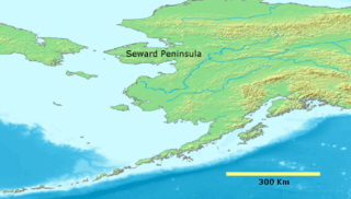
The Seward Peninsula is a large peninsula on the western coast of the U.S. state of Alaska. It projects about 320 kilometers (200 mi) into the Bering Sea between Norton Sound, the Bering Strait, the Chukchi Sea, and Kotzebue Sound, just below the Arctic Circle. The entire peninsula is about 330 kilometers (210 mi) long and 145 km (90 mi)-225 km (140 mi) wide. Like Seward, Alaska, it was named after William H. Seward, the United States Secretary of State who fought for the U.S. purchase of Alaska.

Deering, Alaska City in Alaska, United States

Deering is a city in the Northwest Arctic Borough in the U.S. state of Alaska. It is located on a sandy spit on the Seward Peninsula where the Inmachuk River flows into Kotzebue Sound, 92 km (57 mi) southwest of Kotzebue.

See also

Related Research Articles

Sterling, Alaska Census-designated place in Alaska, United States

Sterling is a census-designated place (CDP) in Kenai Peninsula Borough, Alaska, United States. At the 2010 census the population was 5,617, up from 4,705 in 2000.

Golovin, Alaska City in Alaska, United States

Golovin is a city in Nome Census Area, Alaska, United States. At the 2010 census the population was 156, up from 144 in 2000.

Noorvik, Alaska City in Alaska, United States

Noorvik is a primarily Inupiat city in the Northwest Arctic Borough in the U.S. state of Alaska. As of the 2010 census, the population of the city was 668, up from 634 in 2000. Located in the NANA Region Corp, Noorvik has close ties with the largest city in the region, Kotzebue. Residents speak a dialect of Inupiaq known as Noorvik Inupiaq. Noorvik was the first town to be counted in the 2010 census.

Mountain Village, Alaska City in Alaska, United States

Mountain Village is a city in Kusilvak Census Area, Alaska, United States, located on the Yukon River near the Yukon-Kuskokwim Delta. At the 2010 census the population was 813, up from 755 in 2000.

St. Marys, Alaska City in Alaska, United States

St. Mary's is a city in Kusilvak Census Area, Alaska, United States. The adjacent village of Andreafsky joined with St. Mary's in 1980. At the 2010 census the population was 507, up from 500 in 2000. By 2016, the population was estimated to be 550.

Alatna, Alaska CDP in Alaska, United States

Alatna is a census-designated place (CDP) in the Yukon-Koyukuk Census Area of the Unorganized Borough in the U.S. state of Alaska. The population was 37 at the 2010 census.

Beaver, Alaska CDP in Alaska, United States

Beaver is a census-designated place (CDP) in Yukon-Koyukuk Census Area, Alaska, United States. At the 2010 census the population was 84, unchanged from 2000.

Youngtown, Arizona Town in Arizona, United States

Youngtown is a town in Maricopa County, Arizona, United States. According to the 2010 census, the population of the town is 6,156. Youngtown is the oldest retirement community in the United States.

Winters, Texas City in Texas, United States

Winters is a city in Runnels County, Texas, United States. The population was 2,562 at the 2010 census.

Birch Creek (Yukon River tributary) river in the United States of America

Birch Creek is a 150-mile (240 km) tributary of the Yukon River in the U.S. state of Alaska. Beginning at the confluence of Ptarmigan and Eagle creeks near Porcupine Dome, it flows southwest, then south under the Steese Highway and into the Steese National Conservation Area. It then turns east, then north, again passing under the Steese Highway and entering the Yukon Flats National Wildlife Refuge. Turning northwest, it ends where it splits into two distributaries, Lower Mouth Birch Creek and Upper Mouth Birch Creek, near Birch Creek, Alaska. The distributaries flow into the Yukon River at separate locations downstream of Fort Yukon.

Cape Espenberg landform

Cape Espenberg is a cape located on the Seward Peninsula in Alaska, on the Chukchi Sea coast.

The Black Butte River is located in the Mendocino National Forest of northern California in Glenn and Mendocino counties. It is a tributary to the Middle Fork Eel River and flows northward for 24 miles (39 km) from its headwaters near Round Mountain to the confluence with the Middle Fork Eel River. The Northern California Coastal Wild Heritage Wilderness Act of 2006 added 21 miles (34 km) of the Black Butte River to the National Wild and Scenic Rivers System, of which 17.5 miles (28.2 km) are Wild status and 3.5 miles (5.6 km) are Scenic.

Devil Mountain Lakes

Devil Mountain Lakes is a maar in the western part of Alaska. The lake is considered to be the largest maar in the world.

Dugan, California Unincorporated community in California, United States

Dugan is an unincorporated community in El Dorado County, California. It is located on the Southern Pacific Railroad 3.25 miles (5 km) north-northeast of Latrobe, at an elevation of 1135 feet.

Vanguard, California Unincorporated community in California, United States

Vanguard is an unincorporated community in Fresno and Kings Counties, California. It is located 10 miles (16 km) west-southwest of Lemoore, at an elevation of 253 feet (77 m).

Riverview Park is a census-designated place in Muhlenberg Township, Berks County, Pennsylvania. It is located along the banks of the Schuylkill River about 6 miles north of the city of Reading. As of the 2010 census, the population was 3,380 residents.

Bluff, Alaska 20th-century mining town in Alaska

Bluff, also known as Agookauchuk, was a 20th-century mining town in Alaska. It was built on the Seward Peninsula in 1900, as a result of the Nome Gold Rush. The town was located 55 miles (89 km) southeast of Nome. The settlement was served by a post office for eighteen years, from 1901 to 1919.

Wayne Center is a hamlet in the Town of Rose, Wayne County, New York, United States near the Lyons town line. It is located 4 miles (6 km) west of the hamlet of Rose and 8 miles (13 km) north-northeast of the hamlet of Lyons, at an elevation of 430 feet. The primary cross roads where the hamlet is located are Wayne Center Road, Wayne Center-Rose Road and Ackerman Road.

References

Coordinates: 66°35′41″N163°57′32″W / 66.59472°N 163.95889°W / 66.59472; -163.95889

Geographic coordinate system Coordinate system

A geographic coordinate system is a coordinate system that enables every location on Earth to be specified by a set of numbers, letters or symbols. The coordinates are often chosen such that one of the numbers represents a vertical position and two or three of the numbers represent a horizontal position; alternatively, a geographic position may be expressed in a combined three-dimensional Cartesian vector. A common choice of coordinates is latitude, longitude and elevation. To specify a location on a plane requires a map projection.