
Boa Vista, also written as Boavista, is a desert-like island that belongs to the Cape Verde Islands. At 631.1 km2 (243.7 sq mi), it is the third largest island of the Cape Verde archipelago.
Santa Catarina do Fogo is a concelho (municipality) of Cape Verde. Situated in the southeastern part of the island of Fogo, it covers 32% of the island area, and is home to 14% of its population. Its seat is the city Cova Figueira. The Municipality of Santa Catarina do Fogo was created in 2005; before 2005, it was a parish of the Municipality of São Filipe.

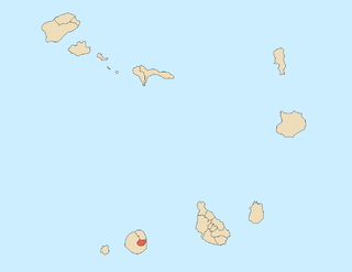
Monte Estância is a mountain in the southeastern part of the island Boa Vista in Cape Verde. At 387 m elevation, it is the island's highest point. It is located 4 km from the Atlantic coast and 23 km southeast of the island capital Sal Rei. It is part of a protected natural space under the statute of natural monument, which covers 739 ha.

Cova Figueira is a city in the southeastern part of the island of Fogo, Cape Verde. In 2010 its population was 1,230, making it the most populated place in the municipality. It is situated 22 km east of the island capital São Filipe. Since 2005, it serves as the seat of Santa Catarina do Fogo Municipality. Its elevation is 480 meters above sea level. The volcano Pico do Fogo is 7.7 km to the northwest. Nearby places include Figueira Pavão in the southwest, Mãe Joana and Estância Roque in the west and Tinteira in the north. Cova Figueira was elevated to a city in 2010.
Figueira Pavão is a settlement in the southeastern part of the island of Fogo, Cape Verde. In 2010 its population was 320. It is situated 3 km southwest of Cova Figueira and 20 km east of the island capital São Filipe. Nearby settlements are Achada Furna to the west and Estância Roque to the north.
Estância Roque is a settlement in the eastern part of the island of Fogo, Cape Verde. In 2010 its population was 411. It is situated 3 km west of Cova Figueira and 19 km east of the island capital São Filipe. Nearby places include Figueira Pavão in the south and Cabeça Fundão in the northwest.
Santa Isabel is a freguesia of Cape Verde. It covers the western part of the island of Boa Vista, and contains the island's capital Sal Rei. The freguesia consists of the following settlements:
Nossa Senhora da Lapa is a freguesia of Cape Verde. It covers the smaller northwestern part of the municipality of Ribeira Brava, on the island of São Nicolau.

Fontainhas is a settlement in the northern part of the island of Santo Antão, Cape Verde. It is situated near the rocky north coast of the island, 2 km southwest of Ponta do Sol and 19 km north of the island capital Porto Novo. The settlement includes the smaller villages Corvo and Forminguinhas, about 1 km west of Fontainhas proper.
Fajã de Baixo is a town in the northern part of the island of São Nicolau, Cape Verde. It is situated 2 km south of Estância de Brás and 5 km northwest of Ribeira Brava.
Hortelã is a settlement in the western part of the island of São Nicolau, Cape Verde. In 2010 its population was 181. It is situated at the southern foot of Monte Gordo, 5 km north of Tarrafal de São Nicolau and 6 km west of Ribeira Brava.

Estância de Baixo is a settlement in the western part of the island of Boa Vista, Cape Verde. Its population was 578 in 2010, making it the island's third most populated place. The village is around 6 km southeast of the island capital of Sal Rei, west of the Deserto de Viana, on the eastern bank of Ribeira do Rabil.
Ribeira Funda is a settlement in the northern part of the island of São Nicolau, Cape Verde. It is situated on the north coast, 2 km northwest of Estância de Brás and 8 km northwest of Ribeira Brava.

Povoação Velha is a village in the southwestern part of the island of Boa Vista, Cape Verde. The village is around 16 km south of the island capital Sal Rei.
Morro is a settlement in the west of the island of Maio in Cape Verde. It is located 5 km north of the island capital Porto Inglês and 6 km south of Calheta. As of the 2010 census, its population was 310. The beach north of the village, Praia do Morro, is a 6.66 km2 nature reserve.

Ribeira do Rabil is a seasonal stream in the central and western part of the island of Boa Vista in Cape Verde. It is 27 km long, and its basin area is 199 km2 (77 sq mi). Its source is in the southeastern part of the island, north of the island's highest point Monte Estância. It flows generally northwest, passes east of the town Rabil and flows into the Atlantic Ocean near the Aristides Pereira International Airport. The estuary, Lagoa do Rabil, is an important wetland area.
Ribeira Prata is a settlement in the northwestern part of the island of São Nicolau, Cape Verde. In 2010 its population was 343. It is situated near the north coast, 3 km northeast of Praia Branca and 11 km north of Tarrafal de São Nicolau.

Monte Santo António is a mountain in the southwestern part of the island Boa Vista in Cape Verde. At 379 m (1,243 ft) elevation, it is the island's second highest point. Like Rocha Estância and Monte Estância, it rises steeply from the surrounding plains. It is part of a protected natural area under the statute of natural monument, covering 459 hectares.
Belém is a settlement in the southwest of the island of Santiago, Cape Verde. It is part of the municipality of Ribeira Grande de Santiago. It is 2 km west of Santana, 6 km north of Porto Gouveia and 11 km northwest of the municipal seat Cidade Velha. In 2010 its population was 382.


