
Tarrafal de São Nicolau is a concelho (municipality) of Cape Verde. Situated in the western part of the island of São Nicolau, it covers 35% of the island area (119.8 km²), and is home to 41% of its population. Its seat is the town Tarrafal de São Nicolau.

Tarrafal de São Nicolau is a city in the western part of the island of São Nicolau, Cape Verde. With a population of 3,733, it is the most populous settlement of the island. It is the seat of the Tarrafal de São Nicolau Municipality, and the main port of the island. It is situated on the west coast, 9 km southwest of Ribeira Brava.

Belém is a settlement in the eastern part of the island of São Nicolau, Cape Verde. It is situated 9 km east of Ribeira Brava.
Cabeçalinho is a settlement in the western part of the island of São Nicolau, Cape Verde. In 2010 its population was 155. It is situated 3 km southwest of Ribeira Brava and 6 km northeast of Tarrafal de São Nicolau. To its northwest is Monte Gordo.
Cachaço is a settlement in the northwestern part of the island of São Nicolau, Cape Verde. It is situated 3 km southwest of Fajã de Baixo and 5 km west of Ribeira Brava. It lies on the national road from Tarrafal de São Nicolau to Ribeira Brava (EN1-SN01). Cachaço lies at about 700 m elevation, at the northeastern foot of Monte Gordo, and partly within the Monte Gordo Natural Park. Several rivers have their source near Cachaço, including the north-flowing Ribeira Grande and the east-flowing Ribeira Brava.
Caleijão is a settlement in the central part of the island of São Nicolau, Cape Verde. It is situated 2 km southwest of Ribeira Brava. Writer Baltasar Lopes da Silva was born in the village. Part of his novel Chiquinho is set in Caleijão.
Carriçal is a settlement in the eastern part of the island of São Nicolau, Cape Verde. It is situated on the south coast, 8 km southeast of Juncalinho and 24 km east of Ribeira Brava. It is the easternmost settlement on the island. Some 8 km east is the island's easternmost point, Ponta Leste. The place was mentioned as Currissal in the 1747 map by Jacques-Nicolas Bellin.
Carvoeiros is a settlement in the northern part of the island of São Nicolau, Cape Verde. It is situated on the north coast, 2 km east of Queimadas and 4 km north of Ribeira Brava.
Covoada is a settlement in the northern part of the island of São Nicolau, Cape Verde. It is situated 7 km northwest of Ribeira Brava.
Estância de Brás is a settlement in the northern part of the island of São Nicolau, Cape Verde. It is situated near the north coast, 2 km north of Fajã de Baixo and 6 km northwest of Ribeira Brava.
Hortelã is a settlement in the western part of the island of São Nicolau, Cape Verde. In 2010 its population was 181. It is situated at the southern foot of Monte Gordo, 5 km north of Tarrafal de São Nicolau and 6 km west of Ribeira Brava.
Morro Brás is a settlement in the eastern part of the island of São Nicolau, Cape Verde. It is situated on the north coast, 11 km east of Ribeira Brava.
Preguiça is a settlement in the central part of the island of São Nicolau, Cape Verde. It is situated on the south coast, 6 km south of Ribeira Brava. It served as the port of Ribeira Brava, after the older Porto de Lapa, 6 km to the northeast, had been abandoned in 1653 due to pirate attacks. The settlement was mentioned as Paraghisi in the 1747 map by Jacques-Nicolas Bellin. In 1820 the Forte do Príncipe Real, now ruined, was built to protect the port. Preguiça's port consists of a stone quay and a short mole. Preguiça Airport is located 3 km north of the village.
Queimadas is a settlement in the central part of the island of São Nicolau, Cape Verde. It is situated 3 km northwest of Ribeira Brava. It is part of the municipality of Ribeira Brava and the parish of Nossa Senhora da Lapa.
Ribeira Funda is a settlement in the northern part of the island of São Nicolau, Cape Verde. It is situated on the north coast, 2 km northwest of Estância de Brás and 8 km northwest of Ribeira Brava.

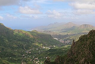
Ribeira Brava is a city on the island of São Nicolau, Cape Verde. It is the seat of the Ribeira Brava Municipality. Its population was 1,936 at the 2010 census. The town is situated in the valley of the river Ribeira Brava, east of the main mountain range of the island. The name of the river is Portuguese for "rough stream", referring to the violent behaviour of the river during rains. The city has a colonial look with Portuguese style buildings, charming parks and gardens, small winding streets, and steep hills.
Talho is a settlement in the central part of the island of São Nicolau, Cape Verde. It is located in the valley of Ribeira Brava, 1 km west of the city Ribeira Brava. In 2010 its population was 308. It is part of the municipality of Ribeira Brava and the parish of Nossa Senhora do Rosário.
Fragata is a settlement in the northwestern part of the island of São Nicolau, Cape Verde. In 2010 its population was 172. It is situated 2 km south of Ribeira Prata and 9 km north of Tarrafal de São Nicolau. It consists of the localities Cruzinha, Geronimo, Santa Barbara and Fragatona (Tope).
Palhal is a settlement in the western part of the island of São Nicolau, Cape Verde. In 2010 its population was 100. It is situated 2 km west of Cabeçalinho and 5 km northeast of Tarrafal de São Nicolau.
Ribeira dos Calhaus is a settlement in the western part of the island of São Nicolau, Cape Verde. It is part of the municipality of Tarrafal de São Nicolau. It is situated in a valley northwest of Monte Gordo, 3 km southeast of Praia Branca and 7 km north of Tarrafal de São Nicolau.


