
The Cape Verde warbler is an Old World warbler in the genus Acrocephalus. It is also known as the Cape Verde cane warbler or Cape Verde swamp warbler, and in Creole as tchota-de-cana, chincherote,. It breeds on Santiago, Fogo, and São Nicolau in the Cape Verde Islands. It previously bred on Brava. This species is found in well-vegetated valleys, avoiding drier areas. It nests in reedbeds, two to three eggs being laid in a suspended nest.

Santiago is the largest island of Cape Verde, its most important agricultural centre and home to half the nation’s population. Part of the Sotavento Islands, it lies between the islands of Maio and Fogo. It was the first of the islands to be settled: the town of Ribeira Grande was founded in 1462. Santiago is home to the nation's capital city of Praia.

Tarrafal de São Nicolau is a concelho (municipality) of Cape Verde. Situated in the western part of the island of São Nicolau, it covers 35% of the island area (119.8 km²), and is home to 41% of its population. Its seat is the town Tarrafal de São Nicolau.

Tarrafal de São Nicolau is a city in the western part of the island of São Nicolau, Cape Verde. With a population of 3,733, it is the most populous settlement of the island. It is the seat of the Tarrafal de São Nicolau Municipality, and the main port of the island. It is situated on the west coast, 9 km southwest of Ribeira Brava.

Monte Gordo is a mountain on the island of São Nicolau, Cape Verde. At 1,312 m elevation, it is the island's highest point. It is situated in the western part of the island, 6 km west of the island capital Ribeira Brava. The mountain is of volcanic origin, less than 1 million years old. The boundary of the municipalities Tarrafal de São Nicolau and Ribeira Brava runs over the mountain. It is part of the Monte Gordo Natural Park.
Tarrafal may refer to several locations in Cape Verde:
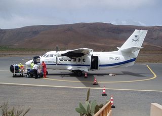
São Nicolau Airport is the domestic airport of the island of São Nicolau, Cape Verde. It is located 3 km north of the village Preguiça and about 3 km south of the island capital Ribeira Brava. Its runway is 1,400 meters and is categorized 3C.

Ponta do Barril is a headland in the western part of the island of São Nicolau, Cape Verde. It is about 8 km northwest of Tarrafal de São Nicolau and 5 km southwest of the nearest village Praia Branca.

Cabeçalinho is a settlement in the western part of the island of São Nicolau, Cape Verde. In 2010 its population was 155. It is situated 3 km southwest of Ribeira Brava and 6 km northeast of Tarrafal de São Nicolau. To its northwest is Monte Gordo.
Cachaço is a settlement in the northwestern part of the island of São Nicolau, Cape Verde. It is situated 3 km southwest of Fajã de Baixo and 5 km west of Ribeira Brava. It lies on the national road from Tarrafal de São Nicolau to Ribeira Brava (EN1-SN01). Cachaço lies at about 700 m elevation, at the northeastern foot of Monte Gordo, and partly within the Monte Gordo Natural Park. Several rivers have their source near Cachaço, including the north-flowing Ribeira Grande and the east-flowing Ribeira Brava.
Hortelã is a settlement in the western part of the island of São Nicolau, Cape Verde. In 2010 its population was 181. It is situated at the southern foot of Monte Gordo, 5 km north of Tarrafal de São Nicolau and 6 km west of Ribeira Brava.
Praia Branca is a town in the northwestern part of the island of São Nicolau, Cape Verde. It is part of the municipality of Tarrafal de São Nicolau. Its population at the 2010 census was 521. It is situated 2 km from the coast, 10 km northwest of Ribeira Brava.

Ribeira Brava is a city on the island of São Nicolau, Cape Verde. It is the seat of the Ribeira Brava Municipality. Its population was 1,936 at the 2010 census. The town is situated in the valley of the river Ribeira Brava, east of the main mountain range of the island. The name of the river is Portuguese for "rough stream", referring to the violent behaviour of the river during rains. The city has a colonial look with Portuguese style buildings, charming parks and gardens, small winding streets, and steep hills.

Cape Verde is a volcanic archipelago situated above an oceanic rise that puts the base of the islands 2 kilometers (1.2 mi) above the rest of the seafloor. Cape Verde has been identified as a hotspot and it has been argued that a mantle plume might be underneath it causing the volcanic activity and associated geothermal anomalies.
Ribeira Prata is a settlement in the northwestern part of the island of São Nicolau, Cape Verde. In 2010 its population was 343. It is situated near the north coast, 3 km northeast of Praia Branca and 11 km north of Tarrafal de São Nicolau.
Fragata is a settlement in the northwestern part of the island of São Nicolau, Cape Verde. In 2010 its population was 172. It is situated 2 km south of Ribeira Prata and 9 km north of Tarrafal de São Nicolau. It consists of the localities Cruzinha, Geronimo, Santa Barbara and Fragatona (Tope).
Palhal is a settlement in the western part of the island of São Nicolau, Cape Verde. In 2010 its population was 100. It is situated 2 km west of Cabeçalinho and 5 km northeast of Tarrafal de São Nicolau.
Ribeira dos Calhaus is a settlement in the western part of the island of São Nicolau, Cape Verde. It is part of the municipality of Tarrafal de São Nicolau. It is situated in a valley northwest of Monte Gordo, 3 km southeast of Praia Branca and 7 km north of Tarrafal de São Nicolau.
The 2016-17 São Nicolau Island League season was the competition of the second-tier football in the island of São Nicolau, Cape Verde. It started on 14 January and finished on 6 May 2017. The tournament was organized and governed by the São Nicolau Regional Football Association. Ultramarina won their 12th title and finished with 36 points and competed in the 2017 Cape Verdean Football Championships. Also Ultramarina qualified into the regional super cup later in the season.


