Related Research Articles

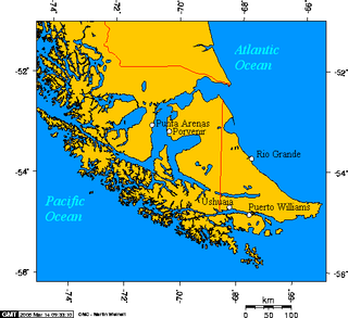
Tierra del Fuego is an archipelago off the southernmost tip of the South American mainland, across the Strait of Magellan. The archipelago consists of the main island, Isla Grande de Tierra del Fuego, with an area of 48,100 km2 (18,572 sq mi), and a group of many islands, including Cape Horn and Diego Ramírez Islands. Tierra del Fuego is divided between Chile and Argentina, with the latter controlling the eastern half of the main island and the former the western half plus the islands south of Beagle Channel and the southernmost islands. The southernmost extent of the archipelago is just north of latitude 56°S.

Ushuaia ( oo-SHWY-ə, Spanish: [uˈswaja], is the capital of Tierra del Fuego, Antártida e Islas del Atlántico Sur Province, Argentina. With a population of nearly 80,000 and a location below the 54th parallel south latitude, Ushuaia claims the title of world's southernmost city. A smaller city with fewer than 3,000 inhabitants, Puerto Williams in Chile, is nearer to the 55th parallel south, at a latitude of 54°56' S compared to Ushuaia at 54°48' S.

Tierra del Fuego, officially the Province of Tierra del Fuego, Antarctica and South Atlantic Islands, is the southernmost, smallest, and least populous Argentine province.

Isla Grande de Tierra del Fuego also formerly Isla de Xátiva is an island near the southern tip of South America from which it is separated by the Strait of Magellan. The western portion (61.4%) of the island is in Chile, while the eastern portion is in Argentina. It forms the major landmass in an extended group of islands or archipelago also known as Tierra del Fuego.
Southernmost settlements are cities, towns, weather stations or permanent military bases which are farther south than latitude 45°S. They are closely related to the Southern Ocean or either the Roaring Forties or Furious Fifties. Antarctic bases are excluded due to not having a permanent population.

Mount Darwin is a peak in Isla Grande de Tierra del Fuego forming part of the Cordillera Darwin, the southernmost range of the Andes, just to the north of the Beagle Channel.

The Southern Fuegian Railway or the Train of the End of the World is a 500 mm gauge steam railway in Tierra del Fuego Province, Argentina. It was originally built as a freight line to serve the prison of Ushuaia, specifically to transport timber. It now operates as a heritage railway into the Tierra del Fuego National Park and is considered the southernmost functioning railway in the world.
Esteban Lucas Bridges was an Anglo-Argentine author, explorer, and rancher. After fighting for the British during World War I, he married and moved with his wife to South Africa, where they developed a ranch with her brother.

Nothofagus betuloides, Magellan's beech or guindo, is a tree native to southern Patagonia.
Cabo San Pío at 55°3′S66°31′W, the southernmost tip of mainland Isla Grande de Tierra del Fuego as well as of Argentina, except for the small islet Islote Blanco that lies about 1.5 kilometres (0.93 mi) off the coast in SW direction.

Estancia Harberton was established in 1886, when the missionary pioneer Thomas Bridges (1842-1898) resigned from the Anglican mission at Ushuaia. The estancia was named for Harberton, the home of his wife, Mary Ann Varder (1842-1922), in Devon, England. Bridges was the author of a dictionary of the Yamana or Yaghan language, and their son Lucas Bridges (1874-1949) would write The Uttermost Part of the Earth about his boyhood, the Yamana, and the family's adventures in getting the dictionary published in Europe.

Mitre Peninsula is the easternmost part of Isla Grande de Tierra del Fuego, located in the very southeast of the island, with its easternmost point, Cabo San Diego, 29 km northwest of Isla de los Estados, from which it is separated by Le Maire Strait. In the south, the peninsula is bounded by the Beagle Channel, and in the north by the Argentine Sea. It is under 4000 km2 in area. The highest peak is Cerro Campana in the southern Montes Negros range with 1026 meters. Monte Atocha is nearby southwest.

The National University of Tierra del Fuego, Antarctica and South Atlantic Islands is an Argentine national university in Tierra del Fuego Province. The campus university is located in the city of Ushuaia. The institution was founded through National Law 26.559, enacted by Congress on November 14, 2009, and was formally established on December 28, 2010.

José Menéndez Menéndez (1846–1918) was a Spanish businessman based in Argentina and Chilean Patagonia. He was the initiator of large companies that remain to this day.
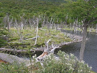
The governments of Chile and Argentina are attempting to eradicate the North American beaver in the Tierra del Fuego area at the southernmost tip of South America. This non-native species was introduced in 1946 as a potential source of commercial fur trading. When the putative fur trade industry failed, the beavers became problematic and the governments agreed to intervene to wipe them out. A June 2011 NPR report stated that the beavers have caused millions of dollars in damages. According to Nature, this plan is the largest eradication project ever attempted.

Thomas Bridges was an Anglican missionary and linguist, the first to set up a successful mission to the indigenous peoples in Tierra del Fuego, an archipelago shared by Argentina and Chile. Adopted and raised in England by George Pakenham Despard, he accompanied his father to Chile with the Patagonian Missionary Society. After an attack by indigenous people, in 1869 Bridges' father, Despard, left the mission at Keppel Island of the Falkland Islands, to return with his family to England. At the age of 17, Bridges stayed with the mission as its new superintendent. In the late 1860s, he worked to set up a mission at what is now the town of Ushuaia along the southern shore of Tierra del Fuego Island.
In late 19th and early 20th centuries, sheep farming expanded across the Patagonian grasslands making the southern regions of Argentina and Chile one of the world's foremost sheep farming areas. The sheep farming boom attracted thousands of immigrants from Chiloé and Europe to southern Patagonia. Early sheep farming in Patagonia was oriented towards wool production but changed over time with the development of industrial refrigerators towards meat export. Besides altering the demographic and economic outlook of Southern Patagonia the sheep farming boom also changed the steppe ecosystem.

Cape San Pablo is a landform located in the Argentine Sea that belongs to the South Atlantic Ocean and is located in the east part of Tierra del Fuego island, the southernmost region of South America. It belongs to the Río Grande Department, in the province of Tierra del Fuego, Antarctica and South Atlantic Islands, located in southern Patagonia. It is located at coordinates: 54 ° 16'57.98 "S 66 ° 41'30.99" W, about 50 km south-east of the city of Rio Grande.
Rae Natalie Prosser de Goodall also known as Natalie Goodall, was a biologist based in Tierra del Fuego Province, Argentina and known for studying the region's flora and fauna.
References
- ↑ Hoffmann, M. A. (1974). The southernmost cattle exploitation in the world. Development action of the Argentine Army in an isle of Tierra del Fuego. (in Spanish). Anales de la Sociedad Rural Argentina.
| | This article about a place in Tierra del Fuego Province, Argentina is a stub. You can help Wikipedia by expanding it. |
Coordinates: 54°58′32.4″S66°44′41″W / 54.975667°S 66.74472°W