Estate Niesky

Last updated
Estate Niesky
Estate Niesky.jpg
USA Virgin Islands location map.svg
Red pog.svg
Location Saint Thomas, U.S. Virgin Islands
Coordinates 18°20′18″N64°57′08″W / 18.33833°N 64.95222°W / 18.33833; -64.95222
Area12.2 acres (4.9 ha)
NRHP reference No. 78003092 [1]
Added to NRHP1978

The property known as Estate Niesky was purchased in 1755 by the Moravian Church in Charlotte Amalie, during the era when America's original Thirteen Colonies were still part of the British Empire. The United States would not take possession of the islands until March 31, 1917, at which time Denmark sold the islands for the sum of $25,000,000 in United States gold coin. [2]

The Moravian Church saw its 1755 acquisition of the estate as a way to supplement its mission at the New Herrnhut Moravian Church in what is now eastern Saint Thomas, U.S. Virgin Islands. The church had been established at Charlotte Amalie for decades when they decided to branch out. Moravian Church bishop Nicolaus Zinzendorf directed Augustus Gottlieb Spangenberg to establish missions in the Netherlands Caribbean colonies. [3] Records discovered during the United States National Register of Historic Places listings assessment give evidence that the original plantation church building was constructed in 1771. [4]

During this era, the Danish West India Company introduced the practice of using enslaved persons to work the sugar plantations. [5] Estate Niesky also used Moravian slaves, but trained them as skilled artisans. [4] Denmark's emancipation of the slaves occurred in 1848. [6]

A new mission house was completed and occupied on July 17, 1829. The old 1771 church building was demolished and a new one consecrated in October 1858. Hurricanes destroyed the new church in both 1867 and 1871, and each time island residents rebuilt the church over its old foundation. The remains of stone walls dividing the site into planting plots are all that survive from the original 1771 plantation, which had been enlarged from the 1755 property. Due to extensive damage during multiple hurricane seasons, the mission had to be rebuilt several times. [7]

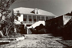
Today, the complex consists of a manse, church, slave quarters, a small cemetery and other outbuildings. The manse, now used as a school and offices, was largely rebuilt after a fire in 1971; still, much of the original 1828 structure's exterior remains." [4]

See also

Related Research Articles

<span class="mw-page-title-main">United States Virgin Islands</span> Territory of the United States

The United States Virgin Islands, officially the Virgin Islands of the United States, are a group of Caribbean islands and an unincorporated and organized territory of the United States. The islands are geographically part of the Virgin Islands archipelago and are located in the Leeward Islands of the Lesser Antilles.

<span class="mw-page-title-main">Danish West Indies</span> Former Danish colony in the Caribbean

The Danish West Indies or Danish Virgin Islands or Danish Antilles were a Danish colony in the Caribbean, consisting of the islands of Saint Thomas with 32 square miles (83 km2); Saint John with 19 square miles (49 km2); and Saint Croix with 84 square miles (220 km2). The islands have belonged to the United States as the Virgin Islands since they were purchased in 1917. Water Island was part of the Danish West Indies until 1905, when the Danish state sold it to the East Asiatic Company, a private shipping company.

<span class="mw-page-title-main">Danish colonization of the Americas</span>

Denmark and the former real union of Denmark–Norway had a colonial empire from the 17th through the 20th centuries, large portions of which were found in the Americas. Denmark and Norway in one form or another also maintained land claims in Greenland since the 13th century, the former up through the twenty-first century.

<span class="mw-page-title-main">Charlotte Amalie, U.S. Virgin Islands</span> Capital city of the United States Virgin Islands

Charlotte Amalie, located on St. Thomas, is the capital and the largest city of the United States Virgin Islands. It was founded in 1666 as Taphus. In 1691, the town was renamed to Charlotte Amalie after the Danish queen Charlotte Amalie of Hesse-Kassel (1650–1714). It has a deep-water harbor that was once a haven for pirates and is now one of the busiest ports of call for cruise ships in the Caribbean, with about 1.5 million-plus cruise ship passengers landing there annually. Protected by Hassel Island, the harbor has docking and fueling facilities, machine shops, and shipyards and was a U.S. submarine base until 1966. The Town has been inhabited for centuries. When Christopher Columbus arrived in 1493, the area was inhabited by Caribs, Arawaks, Ciboney and Taíno native peoples. It is on the southern shore at the head of Saint Thomas Harbor. In 2010 the City had a population of 18,481, which makes it the largest city in the Virgin Islands Archipelago. Hundreds of ferries and yachts pass by the Town each week.

<span class="mw-page-title-main">Saint Thomas, U.S. Virgin Islands</span> One of the main islands of the U.S. Virgin Islands

Saint Thomas is one of the Virgin Islands in the Caribbean Sea, and a constituent district of the United States Virgin Islands (USVI), an unincorporated territory of the United States. Along with surrounding minor islands, it is one of three county-equivalents in the USVI. Together with Saint John, it forms one of the districts of the USVI. The territorial capital and port of Charlotte Amalie is located on the island.

<span class="mw-page-title-main">Hassel Island, U.S. Virgin Islands</span> United States historic place

Hassel Island is a small island of the U.S. Virgin Islands, a United States territory located in the Caribbean Sea. Hassel Island lies in the Charlotte Amalie harbor just south of Saint Thomas and east of Water Island, with which it is part of the sub-district of Water Island.

<span class="mw-page-title-main">History of the United States Virgin Islands</span>

The United States Virgin Islands, often abbreviated USVI, are a group of islands and cays located in the Lesser Antilles of the Eastern Caribbean, consisting of three main islands and fifty smaller islets and cays. Like many of their Caribbean neighbors, the history of the islands is characterized by native Amerindian settlement, European colonization, and the Atlantic slave trade.

<span class="mw-page-title-main">Coral Bay, U.S. Virgin Islands</span> Town and subdistrict in the U.S. Virgin Islands

Coral Bay is a town and a sub-district on the island of St. John in the United States Virgin Islands. It is located on the southeastern side of the island. It was the commercial center of the island in the 19th century as the site of the largest plantation, but from the 1950s onward the population dwindled as the Cruz Bay side of the island with its airport and ferry service to St. Thomas became the gateway to the Virgin Islands National Park. Today Coral Bay is a thriving small community with small outdoor restaurants, grocery stores, businesses and tourism services.

<span class="mw-page-title-main">Cinnamon Bay Plantation</span> United States historic place

Cinnamon Bay Plantation is an approximately 300-acre (1.2 km2) property situated on the north central coast of Saint John in the United States Virgin Islands adjacent to Cinnamon Bay. The land, part of Virgin Islands National Park, was added to the United States National Register of Historic Places on July 11, 1978. Archaeological excavations of the land document ceremonial activity of the Taínos, as well as historic remains of plantation ruins.

<span class="mw-page-title-main">1733 slave insurrection on St. John</span> Revolt in the Danish West Indies

A slave insurrection started on Sankt Jan in the Danish West Indies on November 23, 1733, when 150 African slaves from Akwamu, in present-day Ghana, revolted against the owners and managers of the island's plantations. Led by Breffu, an enslaved woman from Ghana, and lasting several months into August 1734, the slave rebellion was one of the earliest and longest slave revolts in the Americas. The Akwamu slaves captured the fort in Coral Bay and took control of most of the island. They intended to resume crop production under their own control.

<span class="mw-page-title-main">Estate Catherineberg</span>

Estate Catherineberg is a historic mansion on Denmark Hill in Charlotte Amalie, on Saint Thomas island, in the territory of the United States Virgin Islands.

<span class="mw-page-title-main">Sugar production in the Danish West Indies</span> Historical sugar production in the US Virgin Islands

Sugar production in the United States Virgin Islands was an important part of the economy of the United States Virgin Islands for over two hundred years. Long before the islands became part of the United States in 1917, the islands, in particular the island of Saint Croix, was exploited by the Danish from the early 18th century and by 1800 over 30,000 acres were under cultivation, earning Saint Croix a reputation as the "Garden of the West Indies". Since the closing of the last sugar factory on Saint Croix in 1966, the industry has become only a memory.

Grove Place is a settlement on the island of Saint Croix in the United States Virgin Islands. It was added to the National Register of Historic Places in 1978.

<span class="mw-page-title-main">New Herrnhut Moravian Church</span> United States historic place

New Herrnhut Moravian Church is a historic Moravian church in Saint Thomas, U.S. Virgin Islands. The Moravians, a Protestant religious group based in the town of Herrnhut in Saxony, began missionary work in 1732 in St. Thomas and were the first Protestants to begin missionary work among slaves and free Blacks in the Danish West Indies. Missionary work on St. Thomas was initially opposed by planters who didn't want slaves to receive education or religious instruction.

<span class="mw-page-title-main">Charlotte Amalie Historic District</span> United States historic place

The Charlotte Amalie Historic District in Charlotte Amalie in Saint Thomas, U.S. Virgin Islands is a 165.3 acres (0.669 km2) historic district which was listed on the National Register of Historic Places in 1976.

<span class="mw-page-title-main">Friedensthal Mission</span> United States historic place

The Friedensthal Mission, southwest of Christiansted in Saint Croix, U.S. Virgin Islands, was partly built by 1830. Also known as Friedensthal Moravian Church, it was listed on the National Register of Historic Places in 1978. In German, Fridensthal means "valley of peace".

<span class="mw-page-title-main">Estate Carolina Sugar Plantation</span> United States historic place

The Estate Carolina Sugar Plantation near Coral Bay on Saint John, U.S. Virgin Islands is a historic sugar plantation and later rum distillery.

<span class="mw-page-title-main">Fort Willoughby, U.S. Virgin Islands</span>

Fort Willoughby is a historic fort on Hassel Island in the U.S. Virgin Islands.

<span class="mw-page-title-main">Estate Rust Op Twist</span>

Estate Rust-Op-Twist, situated near Christiansted on the island of Saint Croix in the U.S. Virgin Islands, is a former colonial sugar plantation. It was a hub of sugar production from 1755 until the early 1900s, and is currently listed on the US National Register of Historic Places.

References

  1. "National Register Information System". National Register of Historic Places . National Park Service. July 9, 2010.
  2. "Papers Relating to the Foreign Relations of the United States, With the Address of the President to Congress December 4, 1917 - Office of the Historian". history.state.gov. US Department of State. Retrieved 29 June 2023.
  3. "The Moravians: Missionaries in the West Indies". The Danish West-Indies. Retrieved 27 June 2023.
  4. 1 2 3 "Estate Niesky—Historic Places in Puerto Rico and the Virgin Islands; A National Register of Historic Places Travel Itinerary". www.nps.gov. Retrieved 28 June 2023.
  5. "African Diaspora – Virgin Islands National Park (U.S. National Park Service)". National Park Service. Retrieved 27 June 2023.
  6. "The emancipation of the enslaved in 1848". The Danish West-Indies. Danish National Archives. Retrieved 29 June 2023.
  7. "NPGallery Asset Detail". npgallery.nps.gov. NATIONAL REGISTER DIGITAL ASSETS. p. 1.