| Estero Limache | |
|---|---|
| Country | Chile |
The Estero Limache is a river of Chile.
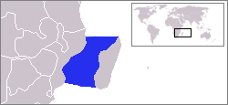
The Mozambique Channel is an arm of the Indian Ocean located between the Southeast African countries of Madagascar and Mozambique. The channel is about 1,600 km (1,000 mi) long and 419 km (260 mi) across at its narrowest point, and reaches a depth of 3,292 m (10,800 ft) about 230 km (143 mi) off the coast of Mozambique. A warm current, the Mozambique Current, flows in a southward direction in the channel, leading into the Agulhas Current off the east coast of South Africa.

The Aconcagua River is a river in Chile that rises from the conflux of two minor tributary rivers at 1,430 metres (4,690 ft) above sea level in the Andes, Juncal River from the east and Blanco River from the south east. The Aconcagua river flows westward through the broad Aconcagua valley and enters the Pacific Ocean near the city of Concon, 20 kilometres (12 mi) north of Valparaíso.

Ralco Hydroelectric Plant is a hydroelectric power station and dam in Bío Bío Region, Chile. The plant uses water from the upper Bío Bío River and produces 690 megawatts (930,000 hp) of electricity. The plant was built by ENDESA in 2004. The project has proven controversial with local indigenous Mapuche since a graveyard had to be flooded by the dam.
El Toro Hydroelectric Plant is a hydroelectric power station in Bío Bío Region, Chile. The plant uses water from Laja River and produces 400 megawatts (540,000 hp) of electricity. The plant was built by ENDESA in 1973.
Antuco Hydroelectric Plant is a hydroelectric power station in Bío Bío Region, Chile. The plant uses water from Laja River and produces 300 megawatts (400,000 hp) of electricity. The plant was built by ENDESA in 1981.

The Andalién River is a river in the province of Concepción, in the Bío Bío Region of Chile. It drains the western side of Chile's Cordillera de la Costa and has a total length of 42 kilometres (26 mi). It is one of the two rivers that bracket the city of Concepción.
The Estero Alhué is a river of Chile.
The Estero Auco is a river of Chile.
The Estero Camisas is a river of Chile.
The Estero Carén is a river of Chile.
The Estero Catemu is a river of Chile.
The Estero Los Loros is a river of Chile.
The Estero Pocuro is a river of Chile.
The Estero Punitaqui is a river of Chile.
The Estero Zamorano is a river of Chile.

The Liquiñe River is a river in the Andes of Los Ríos Region, Chile. The river is most known for the many hotsprings the upwell at its middle reaches where the town of Liquiñe is currently placed.
Peden Cliffs is a line of cliffs, 6 nautical miles (11 km) long, breached near the center by Rhodes Icefall. The cliffs border the north side of Garfield Glacier in the west part of McDonald Heights, Marie Byrd Land. Mapped by United States Geological Survey (USGS) from surveys and U.S. Navy air photos, 1959-65. Named by Advisory Committee on Antarctic Names (US-ACAN) for Irene C. Peden, ionospheric physicist who made investigations on electrical measurements of the ice sheet near Byrd Station, 1970-71.
Larraín Alcalde, or Estación Larraín Alcalde, is a Chilean village located east of Pichilemu, Cardenal Caro Province.
Coordinates: 32°57′S71°28′W / 32.950°S 71.467°W

A geographic coordinate system is a coordinate system that enables every location on Earth to be specified by a set of numbers, letters or symbols. The coordinates are often chosen such that one of the numbers represents a vertical position and two or three of the numbers represent a horizontal position; alternatively, a geographic position may be expressed in a combined three-dimensional Cartesian vector. A common choice of coordinates is latitude, longitude and elevation. To specify a location on a plane requires a map projection.
| This article related to a river in Chile is a stub. You can help Wikipedia by expanding it. |
