See also
| Rivers |  | |
|---|---|---|
| Lakes | ||
| Estero Punitaqui | |
|---|---|
| Country | Chile |
The Estero Punitaqui is a river of Chile.
| Rivers | | |
|---|---|---|
| Lakes | ||

The Arctic Archipelago, also known as the Canadian Arctic Archipelago, is a group of islands north of the Canadian mainland.

Enrique Baldivieso is a province in the Bolivian department of Potosí. It is named after the former vice president Enrique Baldivieso. Its seat is San Agustín with a population of 533 during the census of 2001 situated on the bank of the Turuncha River in San Agustín Canton.
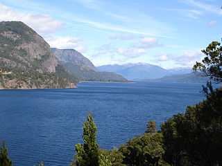
The Lácar Lake is a lake of glacial origin in Neuquén Province, Argentina. It is enclosed in a mountain range of the Andes, at 630 m above mean sea level, approximately at 40°11′S71°32′W. The area around the lake is mostly uninhabited, except for the small city of San Martín de los Andes on its northeastern coast.
Huerta del Maule or Huerta de Maule is a Chilean hamlet (caserío) in San Javier, Linares Province, Maule Region. This picturesque and bucolic place, with a current permanent population of less than 300, used to have far more importance and population two centuries ago, having been a strategic place because of its location at the south of the Maule river and west of the Loncomilla River in central Chile, over the busy, old colonial route from Santiago - Talca to Concepción.
Putagán is a village in the Chilean municipality of Villa Alegre, Province of Linares, Maule Region. Pop. 622. Altitude (meters) 112. Time zone (est) UTC−4(-3DT). Located 292 Kilometers south from Santiago. Its economy is based around agricultural activities like vineyards, rice, corn plantations and lately berries for the European markets.

Loncomilla River is a tributary to the Maule river in Linares Province, Maule Region, Chile. Two rivers join to form the Loncomilla River: the Perquilauquén river and Longaví river.

Ralco Hydroelectric Plant is a hydroelectric power station and dam in Bío Bío Region, Chile. The plant uses water from the upper Bío Bío River and produces 690 megawatts (930,000 hp) of electricity. The plant was built by ENDESA in 2004. The project has proven controversial with local indigenous Mapuche since a graveyard had to be flooded by the dam.
El Toro Hydroelectric Plant is a hydroelectric power station in Bío Bío Region, Chile. The plant uses water from Laja River and produces 400 megawatts (540,000 hp) of electricity. The plant was built by ENDESA in 1973.
Antuco Hydroelectric Plant is a hydroelectric power station in Bío Bío Region, Chile. The plant uses water from Laja River and produces 300 megawatts (400,000 hp) of electricity. The plant was built by ENDESA in 1981.
The Estero Alhué is a river of Chile.
The Estero Auco is a river of Chile.
The Estero Camisas is a river of Chile.
The Estero Carén is a river of Chile.
The Estero Catemu is a river of Chile.
The Estero Coya is a river of Chile.
The Estero Limache is a river of Chile.
The Estero Los Loros is a river of Chile.
The Estero Zamorano is a river of Chile.

The Liquiñe River is a river in the Andes of Los Ríos Region, Chile. The river is most known for the many hotsprings the upwell at its middle reaches where the town of Liquiñe is currently placed.
Coordinates: 30°40′S71°32′W / 30.667°S 71.533°W

A geographic coordinate system is a coordinate system that enables every location on Earth to be specified by a set of numbers, letters or symbols. The coordinates are often chosen such that one of the numbers represents a vertical position and two or three of the numbers represent a horizontal position; alternatively, a geographic position may be expressed in a combined three-dimensional Cartesian vector. A common choice of coordinates is latitude, longitude and elevation. To specify a location on a plane requires a map projection.
| This article related to a river in Chile is a stub. You can help Wikipedia by expanding it. |