
Calabarzon, sometimes referred to as Southern Tagalog and designated as Region IV‑A, is an administrative region in the Philippines. The region comprises five provinces: Batangas, Cavite, Laguna, Quezon, and Rizal; and one highly urbanized city, Lucena. It is the most populous region in the Philippines, according to the Philippine Statistics Authority (PSA), having over 16.1 million inhabitants in 2020, and is also the country's second most densely populated after the National Capital Region. It is situated southeast of Metro Manila, and is bordered by Manila Bay and South China Sea to the west, Lamon Bay and the Bicol Region to the east, Tayabas Bay and the Sibuyan Sea to the south, and Central Luzon to the north. It is home to places like Mount Makiling near Los Baños, Laguna, and Taal Volcano in Batangas. Calamba City is the regional center while Antipolo is the most populous city in the region.

Laguna de Bay, also known as Laguna Lake and alternatively spelled "Laguna de Bae", is the largest lake in the Philippines. It is located southeast of Metro Manila, between the provinces of Laguna to the south and Rizal to the north. A freshwater lake, it has a surface area of 911–949 km2, with an average depth of about 2.8 meters and an elevation of about one meter above sea level. The lake is shaped like a crow's foot, with two peninsulas jutting out from the northern shore and filling the large volcanic Laguna Caldera. In the middle of the lake is the large island of Talim.

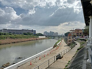
The Pasig River is a water body in the Philippines that connects Laguna de Bay to Manila Bay. Stretching for 25.2 kilometers (15.7 mi), it bisects the Philippine capital of Manila and its surrounding urban area into northern and southern halves. Its major tributaries are the Marikina River and San Juan River. The total drainage basin of the Pasig River, including the basin of Laguna de Bay, covers 4,678 square kilometers (1,806 sq mi).
Lakandula was the title of the last lakan or paramount ruler of pre-colonial Tondo when the Spaniards first conquered the lands of the Pasig River delta in the Philippines in the 1570s.

Malate is a district of Manila, Philippines. Together with the district of Ermita, it serves as Manila's center for commerce and tourism.
The Marikina River is a river in eastern Metro Manila, Philippines. It is the largest tributary of the Pasig River, with headwaters located in the Sierra Madre Mountains in Rodriguez, Rizal province.

In early Philippine history, the Tagalog settlement at Tondo, sometimes referred to as the Kingdom of Tondo, was a major trade hub located on the northern part of the Pasig River delta on Luzon island. Together with Maynila, the polity (bayan) that was also situated on the southern part of the Pasig River delta, Tondo had established a shared monopoly on the trade of Chinese goods throughout the rest of the Philippine archipelago, making it an established force in trade throughout Southeast Asia and East Asia.
In early Philippine history, the rank of lakan denoted a "paramount ruler" of one of the large coastal barangays on the central and southern regions of the island of Luzon.
Namayan, also called Sapa, Maysapan, and sometimes Lamayan, was an independent indigenous polity on the banks of the Pasig River in the Philippines. It is believed to have achieved its peak in 1175, and to have gone into decline sometime in the 13th century, although it continued to be inhabited until the arrival of European colonizers in the 1570s.

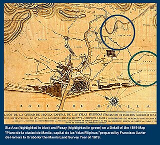
The Battle of Bangkusay, on June 3, 1571, was a naval engagement that marked the last resistance by locals to the Spanish Empire's occupation and colonization of the Pasig River delta, which had been the site of the indigenous polities of Rajahnate of Maynila and Tondo.
In Philippine history, the Tagalog bayan of Maynila was one of the most cosmopolitan of the early historic settlements on the Philippine archipelago. Fortified with a wooden palisade which was appropriate for the predominant battle tactics of its time, it lay on the southern part of the Pasig River delta, where the district of Intramuros in Manila currently stands, and across the river from the separately-led Tondo polity.
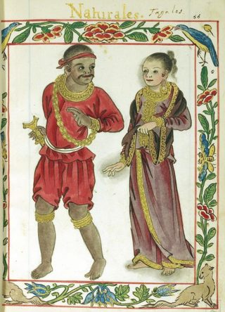
In early Philippine history, barangay is the term historically used by scholars to describe the complex sociopolitical units that were the dominant organizational pattern among the various peoples of the Philippine archipelago in the period immediately before the arrival of European colonizers. Academics refer to these settlements using the technical term "polity", but they are usually simply called "barangays".

The Pasig River is a river in the Philippines running through the heart of Manila. It flows from Laguna de Bay to Manila Bay for 26 kilometers (16 mi). Its average width is 50 meters (160 ft) and average depth around 4–6 meters (13–20 ft). The river runs through some of the most populated areas in the Philippines.

Radial Road 10, more commonly referred to as R-10, is a planned network of roads and bridges that all together would form the tenth radial road of Manila in the Philippines. It is the westernmost of the radial roads north of the Pasig River running north–south close to the shoreline of Manila Bay. When completed, the road would link the City of Manila with Navotas, and the northern coastal provinces of Bulacan, Pampanga, and Bataan in Central Luzon.

North Bay Boulevard is a 2.34-kilometer-long (1.45 mi) two- to four-lane access road in the Navotas Fish Port Complex of northern Metro Manila, Philippines. It is one of the main roads in Navotas which travels north-south through the southern parts of the city running parallel to Radial Road 10 (R-10) to the west. The road links the Balut area of Tondo in Manila and San Rafael Village in the south to the central Navotas barangay of Bagumbayan South in the north. It was named after its location in Manila Bay north of the Manila North Harbor complex.

The Estero de Vitas is one of the rivulets, known as esteros, which delineated the small islands which historically constituted the city of Manila and its predecessors, the Tagalog polities of Maynila and Tondo. These esteros, along with the larger rivers of Manila Bay and the Pasig River delta, originally formed an important connecting network which allowed the precolonial polities of that Tagalog and Kapampangan peoples.

Santo Niño is an administrative division in southern Metro Manila, the Philippines. It is a barangay in the city of Parañaque immediately surrounding Ninoy Aquino International Airport on its west and south sides. A large portion of the village extends into the property of the airport grounds to include Terminal 1 as well as the western half of Runway 06/24. The village has a total land area of 245.97 hectares of which about 55% is occupied by the airport complex. Its population is concentrated in the areas along the Estero de Tripa de Gallina.

Manila's 1st congressional district is one of the six congressional districts of the Philippines in the city of Manila. It has been represented in the House of Representatives of the Philippines since 1916 and earlier in the Philippine Assembly from 1907 to 1916. The district consists of barangays 1 to 146 in the western part of the Manila district of Tondo, west of Dagupan Street, Estero de Vitas and Estero de Sunog Apog bordering Navotas. It used to encompass the entire district of Tondo until 1972, as well as the districts of Binondo, Intramuros, and San Nicolas until 1949 due to the revision of Manila's city charter. It is currently represented in the 19th Congress by Ernesto M. Dionisio Jr. of Aksyon Demokratiko.
Manila's 2nd congressional district is one of the six congressional districts of the Philippines in the city of Manila. It has been represented in the House of Representatives of the Philippines since 1916 and earlier in the Philippine Assembly from 1907 to 1916. The district consists of barangays 147 to 267 in the eastern part of the Manila district of Tondo, east of Dagupan Street, Estero de Vitas and Estero de Sunog Apog bordering Navotas and southern Caloocan. It is currently represented in the 19th Congress by Rolando M. Valeriano of the National Unity Party (NUP) and Asenso Manileño.


