Eticuera Creek

Last updated
Eticuera Creek
Eticuera Creek.jpg
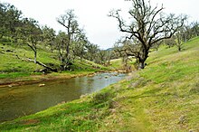
The turbulent waters of Eticuera Creek after a large storm, February 2017
Relief map of California.png
Red pog.svg
Location of the mouth of Eticuera Creek within California
Location
Country United States
State California
RegionNorthern Napa County
Physical characteristics
Mouth Lake Berryessa
  coordinates
38°40′26″N122°16′09″W / 38.6739°N 122.2691°W / 38.6739; -122.2691 Coordinates: 38°40′26″N122°16′09″W / 38.6739°N 122.2691°W / 38.6739; -122.2691
Length14 mi (23 km)
Basin features
Tributaries 
  rightKnoxville Creek, Zim Zim Creek, Adams Creek
Normal flows in upper Eticuera Creek during a calm winter day Upper Eticuera Creek.jpg
Normal flows in upper Eticuera Creek during a calm winter day

Eticuera Creek is one of four primary tributaries that drain into Lake Berryessa in northern Napa County, California. [1] The other three are Pope Creek, Capell Creek, and Putah Creek.

Eticuera Creek drains a watershed that is approximately 53 square miles (140 km2). The creek generally drains in a north to south direction.

The upper reaches of the watershed also once supported the now defunct mining town of Knoxville. [2]

Related Research Articles

Wine Country Area of Northern California known as a wine-growing region

Wine Country is the region of California, in the northern Bay Area, known worldwide as a premier wine-growing region. The region is famed for its wineries, its cuisine, Michelin star restaurants, boutique hotels, luxury resorts, historic architecture, and culture. Viticulture and wine-making have been practiced in the region since the Spanish missionaries from Mission San Francisco Solano established the first vineyards in 1812.

Napa River River in California, United States

The Napa River is a river approximately 55 miles (89 km) long in the U.S. state of California. It drains a famous wine-growing region called the Napa Valley, in the mountains north of the San Francisco Bay. Milliken Creek and Mt. Veeder watersheds are a few of its many tributaries. The river mouth is at Vallejo, where the intertidal zone of fresh and salt waters flow into the Carquinez Strait and the San Pablo Bay.

Lake Berryessa Reservoir in California, United States

Lake Berryessa is the largest lake in Napa County, California. This reservoir in the Vaca Mountains was formed following the construction of the Monticello Dam on Putah Creek in the 1950s. Since the early 1960s, this reservoir has provided water and hydroelectricity to the North Bay region of the San Francisco Bay Area.

Putah Creek River in California

Putah Creek is a major stream in Northern California, a tributary of the Yolo Bypass, and ultimately, the Sacramento River. The 85-mile-long (137 km) creek has its headwaters in the Mayacamas Mountains, a part of the Coast Range, and flows east through two dams. First, Monticello Dam forms Lake Berryessa, below which Putah Creek forms the border of Yolo and Solano Counties, and then flows to the Putah Diversion Dam and Lake Solano. After several drought years in the late 1980s, the majority of Putah Creek went dry, prompting a landmark lawsuit that resulted in the signing of the Putah Creek Accord in 2000. The Accord established releases from the dams to maintain stream flows in Putah Creek, with natural flow regimes which spike in winter/spring and ebb in summer/fall. The restoration of natural flow regimes has resulted in a doubling of riparian bird species and a return of spawning native steelhead trout and Chinook salmon, as well as protecting the livelihood of farmers on the lower watershed.

Sonoma Creek Stream in California

Sonoma Creek is a 33.4-mile-long (53.8 km) stream in northern California. It is one of two principal drainages of southern Sonoma County, California, with headwaters rising in the rugged hills of Sugarloaf Ridge State Park and discharging to San Pablo Bay, the northern arm of San Francisco Bay. The watershed drained by Sonoma Creek is roughly equivalent to the wine region of Sonoma Valley, an area of about 170 square miles (440 km2). The State of California has designated the Sonoma Creek watershed as a “Critical Coastal Water Resource”. To the east of this generally rectangular watershed is the Napa River watershed, and to the west are the Petaluma River and Tolay Creek watersheds.

Monticello Dam Dam in Napa County, California.

Monticello Dam is a 304-foot (93 m) high concrete arch dam in Napa County, California, United States, constructed between 1953 and 1957. The dam impounded Putah Creek to create Lake Berryessa in the Vaca Mountains.

Arroyo Seco (Sonoma County) Stream in Sonoma County, California

Arroyo Seco is a 6.9-mile-long (11.1 km) tributary stream to Schell Creek in southern Sonoma County, California, United States. In Spanish arroyo seco means "dry creek".

Cobb Mountain Mountain in California

Cobb Mountain is the tallest mountain in the Mayacamas Mountains of California.

San Juan Creek River in Orange County, California, United States

San Juan Creek, also called the San Juan River, is a 29-mile (47 km) long stream in Orange and Riverside Counties, draining a watershed of 133.9 square miles (347 km2). Its mainstem begins in the southern Santa Ana Mountains in the Cleveland National Forest. It winds west and south through San Juan Canyon, and is joined by Arroyo Trabuco as it passes through San Juan Capistrano. It flows into the Pacific Ocean at Doheny State Beach. San Juan Canyon provides a major part of the route for California State Route 74.

Upper Penitencia Creek is actually one of two creeks by the name Penitencia Creek in the northeastern Santa Clara Valley of Santa Clara County, California. They are both tributaries of Coyote Creek. The upper creek was diverted southwestward, connecting it directly to Coyote Creek ca. 1850 by a farmer to irrigate his fields, permanently splitting Upper Penitencia Creek from Lower Penitencia Creek. Upper Penitencia Creek drains the western slopes of Mount Hamilton of the Diablo Range, and passes through Alum Rock Park, before ending at its confluence with Coyote Creek at Berryessa Road. In December 2018, the San Francisco Estuary Institute published a report commissioned by the Santa Clara Valley Water District to establish a vision for Upper Penitencia Creek's lower four miles focusing on ways "to expand flow conveyance and flood water storage from the Coyote Creek confluence upstream to the Dorel Drive bridge in a manner that works with the existing landscape features and supports habitats for native species".

East Branch North Fork Feather River

The East Branch North Fork Feather River is a left tributary of the North Fork Feather River in the northern Sierra Nevada, Plumas County, California. Primarily within the Plumas National Forest, its course extends from Paxton to Belden.

Rancho Las Putas was a 35,516-acre (143.73 km2) Mexican land grant in present-day Napa County, California given in 1843 by Governor Manuel Micheltorena to José de Jesús Berreyesa and Sexto "Sisto" Berreyesa. The name Las Putas came from Putah Creek, which ran through the property. Most of the grant is now covered by Lake Berryessa.

Monticello was a town in Napa County, California. The site of the settlement is completely covered by Lake Berryessa.

Snell Creek is a 2.1-mile-long (3.4 km) watercourse in Napa County, California. It is situated approximately five miles north of Aetna Springs and is a tributary of Butts Creek, which ultimately merges into Putah Creek.

Carneros Creek (Napa River tributary)

Carneros Creek is a south by southeastward flowing stream originating in the southernmost Mayacamas Mountains, in Napa County, California. It is the southernmost tributary to the Napa River, entering 2.5 miles (4.0 km) north of San Pablo Bay and 5 miles (8.0 km) south of the town of Napa.

Zim Zim Falls

Zim Zim Falls is a 100+ ft tall waterfall in northern Napa County, California in the Knoxville Wildlife Area. This area is also a part of the much larger Berryessa-Snow Mountain National Monument. The waterfall became accessible to the public in 2005 after the wildlife area was expanded by 12,000 acres. The falls are located along Zim Zim Creek which is a tributary of Eticuera Creek. The water from the falls eventually flows into Lake Berryessa via Eticuera Creek.

LNU Lightning Complex fires 2020 wildfire in California

The LNU Lightning Complex fires were a large complex of wildfires that burned during the 2020 California wildfire season across much of the Wine Country area of Northern California – Lake, Napa, Sonoma, Solano, and Yolo Counties, from August 17 to October 2, 2020. The complex was composed of numerous lightning-sparked fires, most of which were small. However, while they initially started separate from each other, the Hennessey Fire eventually grew to merge with the Gamble, Green, Markley, Spanish, and Morgan Fires, scorching 192,000 acres (777 km2) by itself, for a total burn area of 363,220 acres (1,470 km2) in the complex. The fire, which burned in the hills surrounding several large cities, such as Fairfield, Napa, and Vacaville, destroyed 1,491 structures and damaged a further 232. In all, six people were killed and another five injured. The LNU Lighting Complex is currently the fourth-largest wildfire in the recorded history of California.

Boggs Mountain

Boggs Mountain is a mountain the Mayacamas Mountains in Lake County, California. Part of the mountain holds the Boggs Mountain Demonstration State Forest. About 80% of the trees were burned in the September 2015 Valley Fire.

Big Canyon Creek is a creek in Lake County, California. It is a tributary of Putah Creek.

Rivers of Lake County, California

Rivers of Lake County, California include rivers and creeks in Lake County, California. They are listed below by river basin and alphabetically. Unless otherwise stated, the information is taken from the Geographic Names Information System maintained by the United States Geological Survey. Coordinates, elevations and lengths from this source are approximate.

References

  1. "Eticuera Creek (in Napa County, CA)". california.hometownlocator.com. Retrieved 2017-05-08.
  2. "Learn about a public-private partnership to restore Upper Putah Creek". Davis Enterprise. 2011-08-31. Retrieved 2017-05-08.