Related Research Articles

Botswana, officially the Republic of Botswana, is a landlocked country in Southern Africa. Botswana is topographically flat, with approximately 70 percent of its territory part of the Kalahari Desert. It is bordered by South Africa to the south and southeast, Namibia to the west and north, Zambia to the north and Zimbabwe to the northeast. With a population of slightly over 2.4 million people and a comparable land area to France, Botswana is one of the most sparsely populated countries in the world. It is essentially the nation-state of the Tswana people, who constitute nearly 80 percent of the population.

Gaborone is the capital and largest city of Botswana with a population of 246,325 based on the 2022 census, about 10% of the total population of Botswana. Its agglomeration is home to 534,842 inhabitants at the 2022 census.

The Bechuanaland Protectorate was a protectorate established on 31 March 1885 in Southern Africa by the United Kingdom. It became the Republic of Botswana on 30 September 1966.

The Okavango Delta in Botswana is a vast inland delta formed where the Okavango River reaches a tectonic trough at an altitude of 930–1,000 m in the central part of the endorheic basin of the Kalahari Desert.

The Darwin Medal is one of the medals awarded by the Royal Society for "distinction in evolution, biological diversity and developmental, population and organismal biology".

Ātiu, also known as ʻEnuamanu, is an island of the Cook Islands archipelago, lying in the central-southern Pacific Ocean. Part of the Nga-pu-Toru, it is 214 km (133 mi) northeast of Rarotonga. The population of the 26.9 square kilometres (10.4 sq mi) island has dropped by two-thirds in the last 50 years.

The Boteti River is a natural watercourse in Botswana. It derives flow from the core Okavango Delta through the Thamalakane River in Maun.

Ghanzi is a town in the middle of the Kalahari Desert the western part of the Republic of Botswana in southern Africa. The region is the country's pride in contributing a large portion towards the beef industry. In fact, Ghanzi farmers provide about 75% percent of beef exports, according to the Botswana Meat Commission, primarily to the United Kingdom and the European Union.

The North-West District or Ngamiland is one of the first-level administrative subdivisions of Botswana. For census and administrative purposes Ngamiland is subdivided into Ngamiland East, Ngamiland West and Ngamiland Delta (Okavango). It is governed by a District Commissioner, appointed by the national government, and the elected North-West District Council. The administrative centre is Maun.

Gumare or Gomare is a rural village located in the North-West District of Botswana, near the Okavango Delta. The population of Gumare was 6,067 in 2001 census, but had risen to 8,532 iby the 2011 census.
Translators and scholars have translated the main works attributed to Homer, the Iliad and Odyssey, from the Homeric Greek into English, since the 16th and 17th centuries. Translations are ordered chronologically by date of first publication, with first lines provided to illustrate the style of the translation.
Nokaneng is a village in North-West District, Botswana. It is located close to the Okavango Delta, and is served by Nokaneng Airport. The population of Nokaneng was 1,590 in 2001 census.
Seronga is a village in North-West District, Botswana. It is located close to beginning of the Okavango Delta, and has a local airstrip. The population of Seronga was 1,641 in 2001 census. In 2011 population census, the village had a population of 3716 making it the fourth largest village in Ngamiland West. Seronga village has two government schools namely; Seronga Primary School and Ngambao Junior Secondary School. In addition, Seronga village has other government facilities namely Seronga Sub-Land Board, Seronga Police Station, Seronga Airfield, National Parks and Wildlife Office, Tribal Administration office headed by Senior Chief Representative, 24 hour Clinic with a Doctor.
Bodibeng is a village in North-West District of Botswana. It is located in the southern part of the district, close to the Okavango Delta and Lake Ngami, and has a primary school. The population was 472 in 2001 census. It is located in Ngamiland.
Makunda is a village in Ghanzi District of Botswana. It is located close to the Namibian border. The population was 331 in 2001 census.

The official language of Botswana is English, while Setswana is considered to be a national language. English, which was inherited from colonial rule, is the language of official business and most written communication. Most of the population speak Setswana, but over 20 smaller languages are also spoken. Some of the country's languages are in danger of becoming extinct.

Chobe District is an administrative district in the northern part of Botswana, with the headquarters in Kasane. In 2001 it was merged with Ngamiland, and until 2006 it shared with Ngamiland the North-West District Council as local government. Chobe National Park is in the Chobe District. As of 2011, the total population of the district was 23,347 compared to 18,258 in 2001. The growth rate of population during the decade was 2.49. The total number of workers constituted 12,059 with 6,113 males and 5,947 females, with majority of them working in public administration.
Ngamiland West is one of the subdistricts of Ngamiland District of Botswana.

Ngami is a constituency in the North-West District represented in the National Assembly of Botswana.
References
- ↑ McIntyre, Chris (2014). Botswana Safari Guide: Okavango Delta, Chobe, Northern Kalahari. Bradt Travel Guides. ISBN 9781841624891 – via Google Books.
- ↑ Potten, David (1976). "Etsha: A Successful Resettlement Scheme". Botswana Notes and Records. 8: 105–119. JSTOR 40979461.
- ↑ Elizabeth Terry, M. (1984). "A Survey of Basketmakers, Etsha, Ngamiland, Botswana".
- ↑ "Botswana Notes and Records". Botswana Society. 2000 – via Google Books.[ page needed ]
- ↑ Cunningham, Anthony B. (2014). Applied Ethnobotany: People, Wild Plant Use and Conservation. Taylor & Francis. ISBN 9781136534669 – via Google Books.
- ↑ Campbell, Bruce Morgan; Luckert, Martin Karl (2002). Uncovering the Hidden Harvest: Valuation Methods for Woodland and Forest Resources. Earthscan. ISBN 9781853838095 – via Google Books.
- ↑ "Distribution of population by sex by villages and their associated localities: 2001 population and housing census". Archived from the original on 2007-11-24.
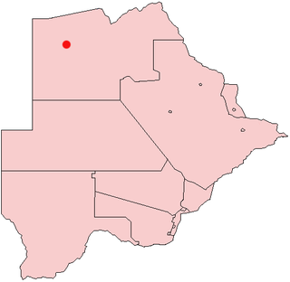
19°06′47″S22°17′48″E / 19.11306°S 22.29667°E