Related Research Articles

Citronelle is a city on the northern border of Mobile County, Alabama, United States. At the 2020 census, the population was 3,946. It is included in the Mobile metropolitan statistical area and is about 34 miles (55 km) north of Mobile.

New Berlin is a city in eastern Waukesha County, Wisconsin, United States. The population was 40,451 at the 2020 census. It is part of the Milwaukee metropolitan area.

In usage in the Southern United States, a bayou is a body of water typically found in a flat, low-lying area. It may refer to an extremely slow-moving stream, river, marshy lake, wetland, or creek. They typically contain brackish water highly conducive to fish life and plankton. Bayous are commonly found in the Gulf Coast region of the southern United States, especially in the Mississippi River Delta, though they also exist elsewhere.
Enbridge Inc. is a multinational pipeline and energy company headquartered in Calgary, Alberta, Canada. Enbridge owns and operates pipelines throughout Canada and the United States, transporting crude oil, natural gas, and natural gas liquids, and also generates renewable energy. Enbridge's pipeline system is the longest in North America and the largest oil export pipeline network in the world. Its crude oil system consists of 28,661 kilometres of pipelines. Its 38,300 kilometre natural gas pipeline system connects multiple Canadian provinces, several US states, and the Gulf of Mexico. The company was formed by Imperial Oil in 1949 as the Interprovincial Pipe Line Company Limited to transport Alberta oil to refineries. Over time, it has grown through acquisition of other existing pipeline companies and the expansion of their projects.

The Tennessee–Tombigbee Waterway is a 234-mile (377 km) artificial U.S. waterway built in the 20th century from the Tennessee River to the junction of the Black Warrior-Tombigbee River system near Demopolis, Alabama. The Tennessee–Tombigbee Waterway links commercial navigation from the nation's midsection to the Gulf of Mexico. The major features of the waterway are 234 miles (377 km) of navigation channels, a 175-foot-deep (53 m) cut between the watersheds of the Tombigbee and Tennessee rivers, and ten locks and dams. The locks are 9 by 110 by 600 feet, the same dimension as those on the Mississippi above Lock and Dam 26 at Alton, Illinois. Under construction for 12 years by the U.S. Army Corps of Engineers, the Tennessee–Tombigbee Waterway was completed in December 1984 at a total cost of nearly $2 billion.

TC Energy Corporation is a major North American energy company, based in the TC Energy Tower building in Calgary, Alberta, Canada, that develops and operates energy infrastructure in Canada, the United States, and Mexico. The company operates three core businesses: Natural Gas Pipelines, Liquids Pipelines and Energy.

The Red Deer River is a river in Alberta and a small portion of Saskatchewan, Canada. It is a major tributary of the South Saskatchewan River and is part of the larger Saskatchewan / Nelson system that empties into Hudson Bay.
The Colonial Pipeline is the largest pipeline system for refined oil products in the U.S. The pipeline – consisting of three tubes – is 5,500 miles (8,850 km) long and can carry 3 million barrels of fuel per day between Texas and New York.
Plains All American Pipeline, L.P. is a master limited partnership engaged in pipeline transport, marketing, and storage of liquefied petroleum gas and petroleum in the United States and Canada. Plains owns interests in 18,370 miles (29,560 km) of pipelines, storage capacity for about 75 million barrels of crude oil, 28 million barrels of NGLs, 68 billion cubic feet of natural gas, and 5 natural gas processing plants. The company is headquartered in the Allen Center in Downtown Houston, Texas. Plains is a publicly traded Master limited partnership. PAA owns an extensive network of pipeline transportation, terminalling, storage and gathering assets in key crude oil and NGL producing basins and transportation corridors at major market hubs in the United States and Canada.

The United States offshore drilling debate is an ongoing debate in the United States about whether, the extent to which, in which areas, and under what conditions, further offshore drilling should be allowed in U.S.-administered waters.
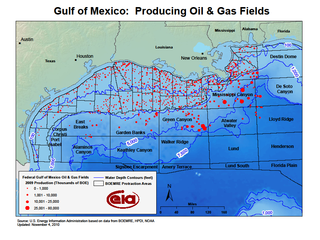
The Mississippi Canyon is an undersea canyon, part of the Mississippi Submarine Valley in the North-central Gulf of Mexico, south of Louisiana. According to the U.S. Geological Survey GLORIA Mapping Program, it is the dominant feature of the north-central Gulf of Mexico. According to GCAGS Transactions, it has an average width of 8 kilometres (5.0 mi), and a length of 120 kilometres (75 mi). The US Minerals Management Service (MMS) applies the name Mississippi Canyon to numbered federal oil and gas lease blocks over a large offshore area centered on, but mostly outside, the submarine canyon.

The Gulf of Mexico is an ocean basin and a marginal sea of the Atlantic Ocean, mostly surrounded by the North American continent. It is bounded on the northeast, north and northwest by the Gulf Coast of the United States; on the southwest and south by the Mexican states of Tamaulipas, Veracruz, Tabasco, Campeche, Yucatán, and Quintana Roo; and on the southeast by Cuba. The Southern U.S. states of Texas, Louisiana, Mississippi, Alabama, and Florida, which border the gulf on the north, are often referred to as the "Third Coast" of the United States.
Following is a timeline of the Deepwater Horizon oil spill for June 2010.
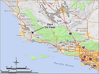
The Zaca Oil Field is an oil field in central Santa Barbara County, California, about 20 miles southeast of Santa Maria. One of several oil fields in the county which produce heavy oil from the Monterey Formation, the field is hidden within a region of rolling hills, north of the Santa Ynez Valley. As of 2011, the principal operator of the oil field is Greka Energy and the operator of the "Zaca Field Extension Project" is Underground Energy. The field is known to contain heavy crude oil and Underground Energy has recently discovered a lower sub-thrust block in the field, which was not previously produced by the field's historical operators. The field was discovered in 1942, reached peak production in 1954, and remains active with more than thirty oil wells and continues to grow.
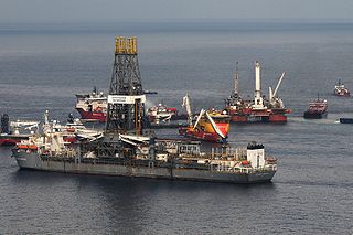
The Deepwater Horizon oil spill occurred between 10 April and 19 September 2010 in the Gulf of Mexico. A variety of techniques were used to address fundamental strategies for addressing the spilled oil, which were: to contain oil on the surface, dispersal, and removal. While most of the oil drilled off Louisiana is a lighter crude, the leaking oil was of a heavier blend which contained asphalt-like substances. According to Ed Overton, who heads a federal chemical hazard assessment team for oil spills, this type of oil emulsifies well. Once it becomes emulsified, it no longer evaporates as quickly as regular oil, does not rinse off as easily, cannot be broken down by microbes as easily, and does not burn as well. "That type of mixture essentially removes all the best oil clean-up weapons", Overton said.

The Cat Creek Oil Field is located near the community of Cat Creek in Petroleum and Garfield counties in the U.S. state of Montana. The geological terminology used by Bowen, the geologist, to define the geological structure of Cat Creek in 1914 was Cat Creek Anticline. Peak of production recorded in 1922, with 11 wells drilling was 3 million barrels of oil.

The Chandeleur Sound is a sound that lies between mainland Louisiana and the Chandeleur Islands in Saint Bernard Parish. It is situated east of Breton Sound and south of Mississippi Sound. It was formed by the mixing of the Gulf of Mexico and the waters of the Mississippi River, protected by the Islands.
Bogue Flower is a stream in the U.S. state of Mississippi. It is a tributary to Eucutta Creek.
References
- ↑ U.S. Geological Survey Geographic Names Information System: Eucutta Creek
- ↑ Baca, Keith A. (2007). Native American Place Names in Mississippi. University Press of Mississippi. p. 35. ISBN 978-1-60473-483-6.
- ↑ "Moon-Hines Flowline Spill". Oil Shark by Cerex. Retrieved 2020-02-15.
31°49′47″N88°42′40″W / 31.8296008°N 88.7111520°W