Lincoln County is a county located in the U.S. state of Montana. As of the 2010 United States Census, the population was 19,687. Its county seat is Libby. The county was founded in 1909 and named for President Abraham Lincoln. The county lies on Montana's north border and thus shares the US-Canadian border with the Canadian province of British Columbia.

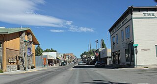
Rexford is a town in Lincoln County, Montana, United States. The population was 105 at the 2010 census.

Lake Koocanusa is a reservoir in British Columbia (Canada) and Montana formed by the damming of the Kootenay River by the Libby Dam in 1972. The Dam was formally dedicated by President Gerald Ford on August 24, 1975.

Eureka Valley station is an abandoned underground streetcar station in San Francisco, California. It was located inside the Twin Peaks Tunnel, very close to its eastern end in the Eureka Valley neighborhood. The station opened in 1918, and was closed in 1972 during the construction of the Market Street Subway.

The Kootenai National Forest is a national forest located in the far northwestern section of Montana and the northeasternmost lands in the Idaho panhandle in the United States, along the Canada–US border. Of the 2.2 million acres (8,900 km2) administered by the forest, less than 3 percent is located in the state of Idaho. Forest headquarters are located in Libby, Montana. There are local ranger district offices in Eureka, Fortine, Libby, Trout Creek, and Troy, Montana. About 53 percent of the 94,272-acre (381.51 km2) Cabinet Mountains Wilderness is located within the forest, with the balance lying in neighboring Kaniksu National Forest.
Saleesh House, also known as Flathead Post, was a North West Company fur trading post built near present-day Thompson Falls, Montana in 1809 by David Thompson and James McMillan of the North West Company. It became a Hudson's Bay Company (HBC) post after that company merged with the North West Company in 1821. Under HBC control the post was better known as Flathead rather than Saleesh. It continued to operate until at least 1855.

Libby Dam is a concrete gravity dam in the northwestern United States, on the Kootenai River in northwestern Montana. Dedicated on August 24, 1975, it is west of the continental divide, seventeen miles (27 km) upstream from the town of Libby.

The Rocky Mountain Trench, also known as the Valley of a Thousand Peaks or simply the Trench, is a large valley on the western side of the northern part of North America's Rocky Mountains. The Trench is both visually and cartographically a striking physiographic feature extending approximately 1,600 km (1,000 mi) from Flathead Lake, Montana to the Liard River, just south of the British Columbia–Yukon border near Watson Lake, Yukon. The trench bottom is 3–16 km (1.9–9.9 mi) wide and is 600–900 m (2,000–3,000 ft) above sea level. The general orientation of the Trench is an almost straight 150/330° geographic north vector and has become convenient as a visual guide for aviators heading north or south.
Montana State Highway 37 is a 67-mile-long (108 km) state highway in the US state of Montana. It begins in downtown Libby, Montana at US 2 and takes a meandering course northeastwards upstream along the Kootenai River and the eastern shore of Lake Koocanusa before terminating at U.S. Route 93 at the northern end of Eureka, Montana. Previously, MT 37 also followed US 93 from Eureka into Whitefish and turned down what is now MT 40 towards US 2 and Glacier National Park until at least 1942.
There are over a dozen lakes named Mud Lake within the U.S. state of Montana.

The Northern Transcon, a route operated by the BNSF Railway, traverses the most northerly route of any railroad in the western United States. This route was originally part of the Chicago, Burlington and Quincy Railroad, Northern Pacific Railway, Great Northern Railway and Spokane, Portland and Seattle Railway systems, merged into the Burlington Northern Railroad system in 1970.
The Flathead Valley, located in Northwestern Montana, is a region of the U.S. state of Montana. It includes Flathead County, and part of Lake County. Notable towns include Bigfork, Kalispell, Columbia Falls, Polson, and Whitefish. The geography of the Flathead roughly corresponds to the valley where Flathead Lake is located. In addition to the lake, the area's proximity to attractions such as Glacier National Park and Whitefish Mountain Resort have made the area a major resort destination. Many outdoor activities can be pursued there such as hiking, backpacking, rafting, canoeing, skiing, hunting, and trout fishing. The Flathead Valley is also home to a portion of the Flathead Indian Reservation.
KJRZ-LP was a radio station in Libby, Montana. It was owned and operated by the Libby Area Chamber of Commerce.

The North Fork Flathead River is a 153-mile (246 km) river flowing through British Columbia, Canada, south into the U.S. state of Montana. It is one of the three primary forks of the Flathead River, the main inflow of Flathead Lake and a tributary of the Columbia River via the Clark Fork River and the Pend Oreille River. The river is sometimes considered the upper headwaters of the Flathead River, although the North Fork is its official name in the U.S. Other naming conventions for the river include Flathead River - North Fork, North Fork of Flathead River, and North Fork of the Flathead River.
The Lake Koocanusa Scenic Byway is a 67-mile (108 km) scenic highway in Lincoln County, Montana, USA, following the Kootenai River and the eastern shore of Lake Koocanusa on Highway 37. The road starts in Libby and proceeds north to Eureka. Lake Koocanusa is formed behind Libby Dam and has a visitors center nearby. The Kootenai River and Lake Koocanusa cut a narrow fjord-like gorge between the Purcell Mountains and the Salish Mountains. The byway is a popular route for visitors visiting the Kootenai National Forest. Snow removal crews work to keep the route open during the winter season. Lodging and services are available in Libby and Eureka.