
The Continuation War, also known as the Second Soviet-Finnish War, was a conflict fought by Finland and Nazi Germany against the Soviet Union during World War II. It began with a Finnish declaration of war and invasion on 25 June 1941 and ended on 19 September 1944 with the Moscow Armistice. The Soviet Union and Finland had previously fought the Winter War from 1939 to 1940, which ended with the Soviet failure to conquer Finland and the Moscow Peace Treaty. Numerous reasons have been proposed for the Finnish decision to invade, with regaining territory lost during the Winter War regarded as the most common. Other justifications for the conflict include Finnish President Risto Ryti's vision of a Greater Finland and Commander-in-Chief Carl Gustaf Emil Mannerheim's desire to annex East Karelia.
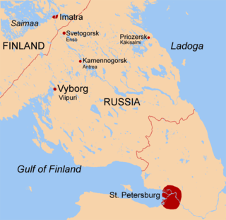
The Karelian Isthmus is the approximately 45–110-kilometre-wide (30–70 mi) stretch of land situated between the Gulf of Finland and Lake Ladoga in northwestern Russia, to the north of the River Neva. Its northwestern boundary is a line from the Bay of Vyborg to the westernmost point of Lake Ladoga, Pekonlahti. If the Karelian Isthmus is defined as the entire territory of present-day Saint Petersburg and Leningrad Oblast to the north of the Neva and also a tiny part of the Republic of Karelia, the area of the isthmus is about 15,000 km2 (5,800 sq mi).

The Dominions of Sweden or Svenska besittningar were territories that historically came under control of the Swedish Crown, but never became fully integrated with Sweden. This generally meant that they were ruled by Governors-General under the Swedish monarch, but within certain limits retained their own established political systems, essentially their diets. Finland was not a dominion, but an integrated part of Sweden. The dominions had no representation in the Swedish Riksdag as stipulated by the 1634 Instrument of Government paragraph 46: "No one, who is not living inside the separate and old borders of Sweden and Finland, have anything to say at Riksdags and other meetings..."

The Karelo-Finnish Soviet Socialist Republic, also called Soviet Karelia or simply known as Karelia, was a republic of the Soviet Union. It existed from 1940 until it was made part of the Russian SFSR in 1956 as the Karelian Autonomous Soviet Socialist Republic. The latter became the Republic of Karelia, a federal subject of Russia, on 13 November 1991.

Ingria is a historical region in what is now northwestern European Russia. It lies along the southeastern shore of the Gulf of Finland, bordered by Lake Ladoga on the Karelian Isthmus in the north and by the River Narva on the border with Estonia in the west. The earliest known indigenous European peoples of the region are the now mostly Eastern Orthodox Izhorians and Votians, as well as the Ingrian Finns who descend from the Lutheran Finnish immigrants who settled in the area in the 17th century, when Finland proper and Ingria were both parts of the Swedish Empire.

The Moscow Peace Treaty was signed by Finland and the Soviet Union on 12 March 1940, and the ratifications were exchanged on 21 March. It marked the end of the 105-day Winter War, upon which Finland ceded border areas to the Soviet Union. The treaty was signed by Vyacheslav Molotov, Andrei Zhdanov and Aleksandr Vasilevsky for the Soviet Union, and Risto Ryti, Juho Kusti Paasikivi, Rudolf Walden and Väinö Voionmaa for Finland. The terms of the treaty were not reversed after the dissolution of the Soviet Union. The Karelian question refers to the debate within Finland over the possible reacquisition of this ceded territory.

Karelians are a Finnic ethnic group who are indigenous to the historical region of Karelia, which is today split between Finland and Russia. Karelians living in Russian Karelia are considered a distinct ethnic group closely related to Finnish Karelians, who are considered a subset of Finns. This distinction historically arose from Karelia having been fought over and eventually split between Sweden and Novgorod, resulting in Karelians being under different cultural spheres.

Karelia is a historical province of Finland, consisting of the modern-day regions of South Karelia and North Karelia. Historical Karelia also extends to the regions of Kymenlaakso, Northern Savonia and Southern Savonia (Mäntyharju).
Mass evacuation, forced displacement, expulsion, and deportation of millions of people took place across most countries involved in World War II. A number of these phenomena were categorised as violations of fundamental human values and norms by the Nuremberg Tribunal after the war ended. The mass movement of people – most of them refugees – had either been caused by the hostilities, or enforced by the former Axis and the Allied powers based on ideologies of race and ethnicity, culminating in the postwar border changes enacted by international settlements. The refugee crisis created across formerly occupied territories in World War II provided the context for much of the new international refugee and global human rights architecture existing today.

Karelia is an area in Northern Europe of historical significance for Russia, Finland, and Sweden. It is currently divided between northwestern Russia and Finland.

Sortavala, previously known as Serdobol (Сердоболь) until 1918, is a town in the Republic of Karelia, Russia, located at the northern tip of Lake Ladoga near the Finnish border, 246 kilometres (153 mi) west of Petrozavodsk, the capital city of the Republic of Karelia. The closest city on the Finnish side of the border is Joensuu, which is located 136 kilometres (85 mi) from Sortavala. In 2021, the population of Sortavala was 19,215.

Swedish Ingria was a dominion of the Swedish Empire from 1583 to 1595 and then again from 1617 to 1721 in what is now the territory of Russia. At the latter date, it was ceded to the Russian Empire in the Treaty of Nystad, at the end of the Great Northern War between the two empires.

The Karelian question or Karelian issue is a dispute in Finnish politics over whether to try to regain control over eastern Karelia and other territories ceded to the Soviet Union in the Winter War and the Continuation War. Despite the name "Karelian question", the term may refer also to the return of Petsamo, ceded parts of Salla and Kuusamo, and four islands in the Gulf of Finland. Sometimes the phrase "debate on the return of the ceded territories" is used. The Karelian question remains a matter of public debate rather than a political issue.
The Order of the Day of the Sword Scabbard, or the Sword Scabbard Declaration, actually refers to two related declarations by the Finnish Commander-in-Chief Carl Gustaf Emil Mannerheim during World War I and World War II against Soviet control of East Karelia.
The Moscow Armistice was signed between Finland on one side and the Soviet Union and United Kingdom on the other side on 19 September 1944, ending the Continuation War. The Armistice restored the Moscow Peace Treaty of 1940, with a number of modifications.

The Karelian people's presence can be dated back to the 7th millennium BC–6th millennium BC. The region itself is rich with fish, lakes, and minerals, and because of that throughout history changed its holder, to this day divided between the Republic of Finland and the Russian Republic.

Viipuri Province was a historical province of Finland from 1812 to 1945.

Vyborg is a town and the administrative center of Vyborgsky District in Leningrad Oblast, Russia. It lies on the Karelian Isthmus near the head of Vyborg Bay, 130 km northwest of St. Petersburg, 245 km east of the Finnish capital Helsinki, and 38 km south of Russia's border with Finland, where the Saimaa Canal enters the Gulf of Finland. The most recent census population of Vyborg is as follows: 72,530 (2021 Census).

The international border between Finland and Russia is 1,340 km (830 mi) long and runs approximately north to south, mostly through taiga forests and sparsely populated rural areas. It does not follow any natural landmarks, such as rivers. It is also an external border of the European Union and NATO.

The borders of Finland are the dividing lines between it and the neighbouring countries of Norway, Russia and Sweden. The total length of land borders of Finland is 2,563 km / 1593 mi.

