
Navigation is a field of study that focuses on the process of monitoring and controlling the movement of a craft or vehicle from one place to another. The field of navigation includes four general categories: land navigation, marine navigation, aeronautic navigation, and space navigation.

An azimuth is the angular measurement in a spherical coordinate system which represents the horizontal angle from a cardinal direction, most commonly north.

Astronomicalcoordinate systems are organized arrangements for specifying positions of satellites, planets, stars, galaxies, and other celestial objects relative to physical reference points available to a situated observer. Coordinate systems in astronomy can specify an object's position in three-dimensional space or plot merely its direction on a celestial sphere, if the object's distance is unknown or trivial.

In astronomy and celestial navigation, the hour angle is the angle between two planes: one containing Earth's axis and the zenith, and the other containing Earth's axis and a given point of interest.

Celestial navigation, also known as astronavigation, is the practice of position fixing using stars and other celestial bodies that enables a navigator to accurately determine their actual current physical position in space or on the surface of the Earth without relying solely on estimated positional calculations, commonly known as "dead reckoning." Celestial navigation is performed without using satellite navigation or other similar modern electronic or digital positioning means.
In observational astronomy, culmination is the passage of a celestial object across the observer's local meridian. These events were also known as meridian transits, used in timekeeping and navigation, and measured precisely using a transit telescope.

The great-circle distance, orthodromic distance, or spherical distance is the distance along a great circle.
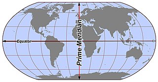
In geography and geodesy, a meridian is the locus connecting points of equal longitude, which is the angle east or west of a given prime meridian. In other words, it is a line of longitude. The position of a point along the meridian is given by that longitude and its latitude, measured in angular degrees north or south of the Equator. On a Mercator projection or on a Gall-Peters projection, each meridian is perpendicular to all circles of latitude. A meridian is half of a great circle on Earth's surface. The length of a meridian on a modern ellipsoid model of Earth has been estimated as 20,003.93 km (12,429.87 mi).
The solar azimuth angle is the azimuth of the Sun's position. This horizontal coordinate defines the Sun's relative direction along the local horizon, whereas the solar zenith angle defines the Sun's apparent altitude.
In astronomical navigation, the intercept method, also known as Marcq St. Hilaire method, is a method of calculating an observer's position on Earth (geopositioning). It was originally called the azimuth intercept method because the process involves drawing a line which intercepts the azimuth line. This name was shortened to intercept method and the intercept distance was shortened to 'intercept'.

Longitude by chronometer is a method, in navigation, of determining longitude using a marine chronometer, which was developed by John Harrison during the first half of the eighteenth century. It is an astronomical method of calculating the longitude at which a position line, drawn from a sight by sextant of any celestial body, crosses the observer's assumed latitude. In order to calculate the position line, the time of the sight must be known so that the celestial position i.e. the Greenwich Hour Angle and Declination, of the observed celestial body is known. All that can be derived from a single sight is a single position line, which can be achieved at any time during daylight when both the sea horizon and the sun are visible. To achieve a fix, more than one celestial body and the sea horizon must be visible. This is usually only possible at dawn and dusk.
Meridian altitude is a method of celestial navigation to calculate an observer's latitude. It notes the altitude angle of an astronomical object above the horizon at culmination.
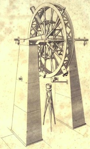
The meridian circle is an instrument for timing of the passage of stars across the local meridian, an event known as a culmination, while at the same time measuring their angular distance from the nadir. These are special purpose telescopes mounted so as to allow pointing only in the meridian, the great circle through the north point of the horizon, the north celestial pole, the zenith, the south point of the horizon, the south celestial pole, and the nadir. Meridian telescopes rely on the rotation of the sky to bring objects into their field of view and are mounted on a fixed, horizontal, east–west axis.
The navigational triangle or PZX triangle is a spherical triangle used in astronavigation to determine the observer's position on the globe. It is composed of three reference points on the celestial sphere:
Polar alignment is the act of aligning the rotational axis of a telescope's equatorial mount or a sundial's gnomon with a celestial pole to parallel Earth's axis.

Sun path, sometimes also called day arc, refers to the daily and seasonal arc-like path that the Sun appears to follow across the sky as the Earth rotates and orbits the Sun. The Sun's path affects the length of daytime experienced and amount of daylight received along a certain latitude during a given season.

The position of the Sun in the sky is a function of both the time and the geographic location of observation on Earth's surface. As Earth orbits the Sun over the course of a year, the Sun appears to move with respect to the fixed stars on the celestial sphere, along a circular path called the ecliptic.
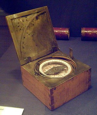
An azimuth compass is a nautical instrument used to measure the magnetic azimuth, the angle of the arc on the horizon between the direction of the Sun or some other celestial object and the magnetic north. This can be compared to the true azimuth obtained by astronomical observation to determine the magnetic declination, the amount by which the reading of a ship's compass must be adjusted to obtain an accurate reading. Azimuth compasses were important in the period before development of the reliable chronometers needed to determine a vessel's exact position from astronomical observations.

The circle of equal altitude, also called circle of position (CoP), is defined as the locus of points on Earth on which an observer sees a celestial object such as the sun or a star, at a given time, with the same observed altitude. It was discovered by the American sea-captain Thomas Hubbard Sumner in 1837, published in 1843 and is the basis of an important method in celestial navigation.
In astronavigation, sight reduction is the process of deriving from a sight the information needed for establishing a line of position, generally by intercept method.


