Meridian altitude

Last updated

Meridian altitude is an astronomical navigation method of calculating an observer's latitude.

Latitude The angle between zenith at a point and the plane of the equator

In geography, latitude is a geographic coordinate that specifies the north–south position of a point on the Earth's surface. Latitude is an angle which ranges from 0° at the Equator to 90° at the poles. Lines of constant latitude, or parallels, run east–west as circles parallel to the equator. Latitude is used together with longitude to specify the precise location of features on the surface of the Earth. On its own, the term latitude should be taken to be the geodetic latitude as defined below. Briefly, geodetic latitude at a point is the angle formed by the vector perpendicular to the ellipsoidal surface from that point, and the equatorial plane. Also defined are six auxiliary latitudes which are used in special applications.

Contents

Principle

This is the simplest calculation of astronomical navigation and is when an observer determines his latitude by measuring the altitude of a heavenly object at the time of its meridian passage. Meridian passage is when the object passes the observer's meridian, i.e. passes through south or north. This is usually done with the sun for a noon latitude but can be done with any heavenly object. Noon is when the sun passes through the meridian.

Meridian (astronomy) great circle passing through the celestial poles, the zenith, and the nadir of a particular location

In astronomy, the meridian is the great circle passing through the celestial poles, as well as the zenith and nadir of an observer's location. Consequently, it contains also the north and south points on the horizon, and it is perpendicular to the celestial equator and horizon. A celestial meridian is coplanar with the analogous terrestrial meridian projected onto the celestial sphere. Hence, the number of celestial meridians is also infinite.

Let us imagine that the sun is overhead (at the zenith) at a point on the equator (latitude 0°) and observer A is standing at this point, the geographical point of the sun. If he were to measure the height of the sun above the horizon with a sextant he would find that the altitude of the sun was 90°. By subtracting this figure from 90° he would find the zenith distance of the sun which is 0°, which is the same as his latitude. Observer B is standing at one of the poles (latitude 90°N or 90°S) he would see the sun on the horizon at an altitude of 0°. By subtracting this from 90° he would find that the zenith distance is 90°, which is his latitude. Observer C at the same time is at latitude 20°N on the same meridian, i.e. on the same longitude as observer A. His measured altitude would be 70° and by subtracting this from 90° gives a 20° zenith distance which in turn is his latitude. In short, the zenith distance of a heavenly object at meridian altitude is the difference in latitude between it and the observer.

Zenith

The zenith is an imaginary point directly "above" a particular location, on the imaginary celestial sphere. "Above" means in the vertical direction opposite to the apparent gravitational force at that location. The opposite direction, i.e. the direction in which gravity pulls, is toward the nadir. The zenith is the "highest" point on the celestial sphere.

Equator Intersection of a spheres surface with the plane perpendicular to the spheres axis of rotation and midway between the poles

An equator of a rotating spheroid is its zeroth circle of latitude (parallel). It is the imaginary line on the spheroid, equidistant from its poles, dividing it into northern and southern hemispheres. In other words, it is the intersection of the spheroid with the plane perpendicular to its axis of rotation and midway between its geographical poles.

Horizon apparent line that separates earth from sky

The horizon or skyline is the apparent line that separates earth from sky, the line that divides all visible directions into two categories: those that intersect the Earth's surface, and those that do not. The true horizon is actually a theoretical line, which can only be observed when it lies on the sea surface. At many locations, this line is obscured by land, trees, buildings, mountains, etc., and the resulting intersection of earth and sky is called the visible horizon. When looking at a sea from a shore, the part of the sea closest to the horizon is called the offing.

Methodology

The estimated time of meridian altitude of the heavenly object is extracted from the nautical almanac. A few minutes before this time the observer starts observing the altitude of the object with a sextant. The altitude of the object will be increasing and the observer will continually adjust the sextant to keep the reflected image of the object on the horizon. As the object passes the meridian a maximum altitude will be observed. The time in UTC of this is observed.

Nautical almanac publication describing the positions of selected celestial bodies for help in navigation

A nautical almanac is a publication describing the positions of a selection of celestial bodies for the purpose of enabling navigators to use celestial navigation to determine the position of their ship while at sea. The Almanac specifies for each whole hour of the year the position on the Earth's surface at which the sun, moon, planets and first point of Aries is directly overhead. The positions of 57 selected stars are specified relative to the first point of Aries.

The altitude obtained is corrected for dip (the error caused by the observers height above the sea) and refraction to obtain the true altitude of the object above the horizon. This is then subtracted from 90° to obtain the angular distance from the position directly above to obtain the zenith distance.

A further correction must then be taken into account to counter the "wobble" of the earth's spin and rotation relative to the sun and planets. This is given in the declination for the body on a particular day in the year (also taken from the nautical almanac). If the declination of the body is in the opposite hemisphere (ie if you are in the northern hemisphere and the declination is in the southern hemisphere) then the declination must be subtracted from your true zenith distance, otherwise the declination is added.

See also

Celestial navigation navigation using astronomical objects to determine position

Celestial navigation, also known as astronavigation, is the ancient and modern practice of position fixing that enables a navigator to transition through a space without having to rely on estimated calculations, or dead reckoning, to know their position. Celestial navigation uses "sights", or angular measurements taken between a celestial body and the visible horizon. The Sun is most commonly used, but navigators can also use the Moon, a planet, Polaris, or one of 57 other navigational stars whose coordinates are tabulated in the nautical almanac and air almanacs.

Navigation The process of monitoring and controlling the movement of a craft or vehicle from one place to another

Navigation is a field of study that focuses on the process of monitoring and controlling the movement of a craft or vehicle from one place to another. The field of navigation includes four general categories: land navigation, marine navigation, aeronautic navigation, and space navigation.

Longitude A geographic coordinate that specifies the east-west position of a point on the Earths surface

Longitude, is a geographic coordinate that specifies the east–west position of a point on the Earth's surface, or the surface of a celestial body. It is an angular measurement, usually expressed in degrees and denoted by the Greek letter lambda (λ). Meridians connect points with the same longitude. By convention, one of these, the Prime Meridian, which passes through the Royal Observatory, Greenwich, England, was allocated the position of 0° longitude. The longitude of other places is measured as the angle east or west from the Prime Meridian, ranging from 0° at the Prime Meridian to +180° eastward and −180° westward. Specifically, it is the angle between a plane through the Prime Meridian and a plane through both poles and the location in question.

Related Research Articles

Declination Astronomical coordinate analogous to latitude

In astronomy, declination is one of the two angles that locate a point on the celestial sphere in the equatorial coordinate system, the other being hour angle. Declination's angle is measured north or south of the celestial equator, along the hour circle passing through the point in question.

Right ascension Astronomical equivalent of longitude

Right ascension is the angular distance of a particular point measured eastward along the celestial equator from the Sun at the March equinox to the point above the earth in question. When paired with declination, these astronomical coordinates specify the direction of a point on the celestial sphere in the equatorial coordinate system.

A solstice is an event occurring when the Sun appears to reach its most northerly or southerly excursion relative to the celestial equator on the celestial sphere. Two solstices occur annually, around June 21 and December 21. The seasons of the year are determined by reference to both the solstices and the equinoxes.

Sextant angle measurement instrument

A sextant is a doubly reflecting navigation instrument that measures the angular distance between two visible objects. The primary use of a sextant is to measure the angle between an astronomical object and the horizon for the purposes of celestial navigation. The estimation of this angle, the altitude, is known as sighting or shooting the object, or taking a sight. The angle, and the time when it was measured, can be used to calculate a position line on a nautical or aeronautical chart—for example, sighting the Sun at noon or Polaris at night to estimate latitude. Sighting the height of a landmark can give a measure of distance off and, held horizontally, a sextant can measure angles between objects for a position on a chart. A sextant can also be used to measure the lunar distance between the moon and another celestial object in order to determine Greenwich Mean Time and hence longitude. The principle of the instrument was first implemented around 1731 by John Hadley (1682–1744) and Thomas Godfrey (1704–1749), but it was also found later in the unpublished writings of Isaac Newton (1643–1727). Additional links can be found to Bartholomew Gosnold (1571–1607) indicating that the use of a sextant for nautical navigation predates Hadley's implementation. In 1922, it was modified for aeronautical navigation by Portuguese navigator and naval officer Gago Coutinho.

Celestial sphere imaginary sphere of arbitrarily large radius, concentric with the observer

In astronomy and navigation, the celestial sphere is an abstract sphere that has an arbitrarily large radius and is concentric to Earth. All objects in the sky can be conceived as being projected upon the inner surface of the celestial sphere, which may be centered on Earth or the observer. If centered on the observer, half of the sphere would resemble a hemispherical screen over the observing location.

Equatorial coordinate system A celestial coordinate system used to specify the positions of celestial objects

The equatorial coordinate system is a celestial coordinate system widely used to specify the positions of celestial objects. It may be implemented in spherical or rectangular coordinates, both defined by an origin at the centre of Earth, a fundamental plane consisting of the projection of Earth's equator onto the celestial sphere, a primary direction towards the vernal equinox, and a right-handed convention.
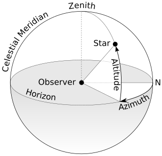
Horizontal coordinate system type of celestial coordinate system that uses the observers local horizon as the fundamental plane

The horizontal coordinate system, also known as topocentric coordinate system, is a celestial coordinate system that uses the observer's local horizon as the fundamental plane. Coordinates of an object in the sky are expressed in terms of altitude angle and azimuth.

Hour angle unit of angle

In astronomy and celestial navigation, the hour angle is one of the coordinates used in the equatorial coordinate system to give the direction of a point on the celestial sphere. The hour angle of a point is the angle between two planes: one containing Earth's axis and the zenith, and the other containing Earth's axis and the given point.

In observational astronomy, culmination is the instant of time of the transit of a celestial object across the observer's local meridian. During each day, every celestial object appears to move along a circular path on the celestial sphere due to the Earth's rotation creating two moments when it crosses the meridian. Except at the geographic poles, any celestial object passing through the meridian has an upper culmination, when it reaches its highest point above the horizon, and nearly twelve hours later, is followed by a lower culmination, when it reaches its lowest point. The time of culmination is often used to mean upper culmination.

In the celestial equatorial coordinate system Σ(α, δ) in astronomy, polar distance (PD) is an angular distance of a celestial object on its meridian measured from the celestial pole, similar to the way declination is measured from the celestial equator.

Navigational instruments refers to the instruments used by nautical navigators and pilots as tools of their trade. The purpose of navigation is to ascertain the present position and to determine the speed, direction etc. to arrive at the port or point of destination.

The intercept method, also known as Marcq St. Hilaire method, is an astronomical navigation method of calculating an observer's position on earth. It was originally called the azimuth intercept method because the process involves drawing a line which intercepts the azimuth line. This name was shortened to intercept method and the intercept distance was shortened to 'intercept'.

Longitude by chronometer is a method, in navigation, of determining longitude using a marine chronometer, which was developed by John Harrison during the first half of the eighteenth century. It is an astronomical method of calculating the longitude at which a position line, drawn from a sight by sextant of any celestial body, crosses the observer's assumed latitude. In order to calculate the position line, the time of the sight must be known so that the celestial position i.e. the Greenwich Hour Angle and Declination, of the observed celestial body is known. All that can be derived from a single sight is a single position line, which can be achieved at any time during daylight when both the sea horizon and the sun are visible. To achieve a fix, more than one celestial body and the sea horizon must be visible. This is usually only possible at dawn and dusk.

Ex-meridian is a celestial navigation method of calculating an observer’s position on Earth. The method gives the observer a position line on which the observer is situated. It is usually used when the Sun is obscured at noon, and as a result, a meridian altitude is not possible. The navigator measures the altitude of the Sun as close to noon as possible and then calculates where the position line lies.

A lunar standstill is the gradually varying range between the northern and the southern limits of the Moon's declination, or the lunistices, over the course of one-half a sidereal month, or 13.66 days. One major, or one minor, lunar standstill occurs every 18.6 years due to the precessional cycle of the lunar nodes at that rate.

The navigational triangle or PZX triangle is a term used in Astro-Navigation, or Celestial Navigation, and its solution can give you your position anywhere on the globe. The sky is described as a Celestial Sphere with a North and South Pole corresponding to our own North and South Pole. Conveniently, the 'Pole Star' lies at the North Pole of the Celestial Sphere.

Sun path

Sun path, sometimes also called day arc, refers to the daily and seasonal arc-like path that the Sun appears to follow across the sky as the Earth rotates and orbits the Sun. The Sun's path affects the length of daytime experienced and amount of daylight received along a certain latitude during a given season.

Circle of equal altitude

The circle of equal altitude also called circle of position, CoP, is the real line of position in celestial navigation. It is defined as the locus of the Earth on which an observer sees a star, at a given time, with the same observed altitude. It was discovered by the American sea-captain Thomas Hubbard Sumner.

References