
The Tamar is a river in south west England that forms most of the border between Devon and Cornwall. A part of the Tamar Valley is a World Heritage Site due to its historic mining activities.
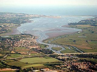
The River Exe in England rises at Exe Head, near the village of Simonsbath, on Exmoor in Somerset, 5.2 miles (8.4 km) from the Bristol Channel coast, but flows more or less directly due south, so that most of its length lies in Devon. It flows for 60 miles (96 km) and reaches the sea at a substantial ria, the Exe Estuary, on the south coast of Devon. Historically, its lowest bridging point was the Old Exe Bridge in Exeter, the largest settlement on the river, but there is now a viaduct for the M5 motorway about 2 miles (3.2 km) south of the city centre.
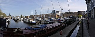
Greenland Dock is the oldest of London's riverside wet docks, located in Rotherhithe in the area of the city now known as Docklands. It used to be part of the Surrey Commercial Docks, most of which have by now been filled in. Greenland Dock is now used purely for recreational purposes; it is one of only two functioning enclosed docks on the south bank of the River Thames, along with the smaller South Dock, to which it is connected by a channel now known as Greenland Cut.

Bristol Harbour is the harbour in the city of Bristol, England. The harbour covers an area of 70 acres. It is the former natural tidal river Avon through the city but was made into its current form in 1809 when the tide was prevented from going out permanently. A tidal by-pass was dug for 2 miles through the fields of Bedminster for the river, known as the "River Avon New Cut", "New Cut", or simply "The Cut". It is often called the Floating Harbour as the water level remains constant and it is not affected by the state of the tide on the river in the Avon Gorge, The New Cut or the natural river southeast of Temple Meads to its source.
The Exeter Ship Canal, also known as the Exeter Canal is a canal leading from the River Exe to Exeter Quay in the city of Exeter, Devon, England. It was first constructed in the 1560s predating the "canal mania" period and is one of the oldest artificial waterways in the UK.

The Avocet Line is the railway line in Devon, England connecting Exeter with Exmouth. It was originally built by the London and South Western Railway, and was historically known as the Exmouth branch railway. The line follows the Exe Estuary for about half of its route, from just outside Topsham to Exmouth, giving views of the estuary. The line is named after the pied avocet, which lives in the estuary.

Exminster is a village situated on the southern edge of the City of Exeter on the western side of the Exeter ship canal and River Exe in the county of Devon, England. It is around 6 km (3.7 mi) south of the centre of Exeter, and has a population of 3,478, increasing to 4,379 at the 2021 census.

The Quayside is an area along the banks (quay) of the River Tyne in Newcastle upon Tyne and Gateshead in Tyne and Wear, North East England, United Kingdom.

Twelve Quays is a ferry terminal and business park which is located between East Float and the River Mersey at Birkenhead, in England. Twelve Quays separates Woodside from Seacombe.
Swansea Docks is the collective name for several docks in Swansea, Wales. The Swansea docks are located immediately south-east of Swansea city centre. In the mid-19th century, the port was exporting 60% of the world's copper from factories situated in the Tawe Valley. The working docks area today is owned and operated by Associated British Ports as the Port of Swansea and the northern part around the Prince of Wales Dock is undergoing re-development into a new urban area branded the SA1 Swansea Waterfront.

The A379 is a road in the English county of Devon. It links points on the edges of that county's two principal cities, Exeter and Plymouth, by an indirect and largely coastal route. The A38 provides a faster and more direct inland route between Exeter and Plymouth, whilst the A380 provides a similarly faster route between Exeter and the Torbay area. However the A379 serves many small coastal communities and ports along the coast. The indented nature of the South Devon coast means that the road is usually out of sight of the sea, but the many rivers and estuaries are crossed by bridges and, in one case, a cable ferry.

Countess Wear is a district within the city of Exeter, Devon, England. It lies about two miles south-east of the city centre, on the north bank of the estuary of the River Exe. Historically an estate known as Weare, part of the manor of Topsham, was in this area. From the late 13th century, the construction of weirs in the River Exe by the Countess, and later, the Earls of Devon damaged the prosperity of Exeter to the benefit of Topsham which was downstream of the obstructions, and was owned by the Earls.

The Butts Ferry is a hand-operated pedestrian cable ferry that crosses the River Exe in the city of Exeter in the English county of Devon. The crossing has been in use since at least 1641, but the name is more recent. The ferry is named after Mr George Butt, who fought to keep the ferry open when the City Council attempted to close it in 1971.

Aberdeen Harbour, rebranded as the Port of Aberdeen in 2022, is a sea port located in the city of Aberdeen on the east coast of Scotland. The port was first established in 1136 and has been continually redeveloped over the centuries to provide a base for significant fishing and ship building industries. Since the 1970s it has provided support to the offshore oil and gas industry operating in the North Sea and it is the main commercial port in the north east of Scotland.

Exeter Power Station is a former coal-fired power station on the River Exe quayside, Exeter, England.

The Port of Southampton is a major passenger and cargo port located in the central part of the south coast of England. It has been an important port since the Roman occupation of Britain nearly two thousand years ago, and has a multifaceted history. From the Middle Ages to the end of the 20th century, it was a centre for naval shipbuilding and a departure point for soldiers going to war. The port also played a role in the development of hovercraft, flying boat services, seaplanes and the Spitfire fighter plane. Before the advent of jet travel, Southampton was Britain's gateway to the world. The port also played a minor role in the history of Britain's canals.
The Port of Bridgwater is a port, originally located in the town of Bridgwater, Somerset, England. Created under the Bridgwater Navigation and Quays Act 1845 it extends from Brean Down to Hinkley Point in Bridgwater Bay, and parts of the rivers Parrett, River Brue and River Axe. Although no ships now dock in the town, in 2001 103,613 (metric) tonnes of cargo were handled within the area of the Port Authority, most of which were stone products through the wharf at Dunball.
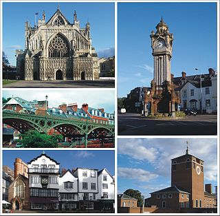
Exeter is a cathedral city and the county town of Devon, South West England. It is situated on the River Exe, approximately 36 mi (58 km) northeast of Plymouth and 65 mi (105 km) southwest of Bristol.

Town Quay is a quay and pier in Southampton, England.

Exeter Valley Parks are six parks around Exeter, England, managed by Devon Wildlife Trust. The management was transferred from Exeter City Council, which owns the parks, in May 2019.

