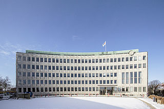
Gentofte Kommune is a municipality in the Capital Region of Denmark on the east coast of the island of Zealand (Sjælland) in eastern Denmark. It covers an area of 25.54 km2 (9.86 sq mi), and has a total population of 74,548. Since 1993, its mayor has been Hans Toft, a member of the Conservative People's Party.

Sorgenfri is a neighbourhood in Lyngby-Taarbæk municipality in Greater Copenhagen lying just north of Kongens Lyngby.

Virum is a mostly residential, suburban neighbourhood in Lyngby-Taarbæk Municipality, located on both sides of Lyngby Kongevej, approximately 15 km north of central Copenhagen, Denmark. The neighbourhood is bounded by Lake Furesø to the west, Holte in Rudersdal Municipality to the north, Brede to the east and Kongens Lyngby and Sorgenfri to the south. Virum station is located on the Hillerød radial of the S-train network and is served by the Btrains.
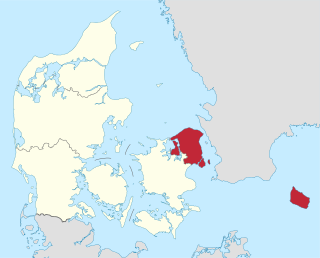
The Capital Region of Denmark is the easternmost administrative region of Denmark, established on January 1, 2007 as part of the 2007 Danish Municipal Reform, which abolished the traditional counties and set up five regions. At the same time, smaller municipalities were merged into larger units, cutting the number of municipalities from 271 before 1 January 2006, when Ærø Municipality was created, to 98. The Capital Region has 29 municipalities. The reform was implemented on January 1, 2007. The main task for the Danish regions are hospitals and healthcare. It is not to be confused with the Copenhagen Metropolitan Area nor with the Øresund Region. Unlike the counties (1970-2006) the regions are not municipalities and are thus not allowed to have coat of arms, but only logotypes, and cannot "shuffle money around" from one area of expenditure to another area of expenditure, that is, use money for any other purpose than has been stated specifically, but must pay money not used back rather like departments or agencies of the central government. The regions do not levy any taxes but are financed only through block grants.

Christianshavn is a neighbourhood in Copenhagen, Denmark. Part of the Indre By District, it is located on several artificial islands between the islands of Zealand and Amager and separated from the rest of the city centre by the Inner Harbour. It was founded in the early 17th century by Christian IV as part of his extension of the fortifications of Copenhagen. Originally, it was laid out as an independent privileged merchant's town with inspiration from Dutch cities but it was soon incorporated into Copenhagen proper. Dominated by canals, it is the part of Copenhagen with the most nautical atmosphere.

The fortifications of Copenhagen is the broad name for the rings of fortifications surrounding the city of Copenhagen. They can be classified historically as follows:

Sorgenfri Palace is a royal residence of the Danish monarch, located in Lyngby-Taarbæk Municipality, on the east side of Lyngby Kongevej, in the northern suburbs of Copenhagen. The surrounding neighbourhood is called Sorgenfri after it. Only the cellar and foundations survive of the first Sorgenfri House, which was built in 1705 to design by François Dieussart. The current house was built in 1756 by Lauritz de Thurah and later adapted and extended by Peter Meyn in the 1790s. Lauritz de Thurah has also designed buildings which flank the driveway closer to the road.

The fortifications of Copenhagen underwent a comprehensive modernization and expansion in the 17th century. The project was commenced and was largely the masterplan of Christian IV in the early 17th century but was continued and completed by his successors. The new fortifications relied on the existing, medieval fortifications of the city but the fortified area was extended and a defensive ring around the city completed particularly with new edifices facing the sea. The ring fortification consisted of four bastioned ramparts and an annexed citadel as well as various outworks.
Gammelholm is a predominantly residential neighbourhood in the city centre of Copenhagen, Denmark. It is bounded by the Nyhavn canal, Kongens Nytorv, Holmens Kanal, Niels Juels Gade and the waterfront along Havnegade. For centuries, the area was the site of the Royal Naval Shipyard, known as Bremerholm, but after the naval activities relocated to Nyholm, it came under residential redevelopment in the 1860s and 1870s. The new neighbourhood was planned by Ferdinand Meldahl and has also been referred to as "Meldahl's Nine Streets". Apart from the buildings which face Kongens Nytorv, which include the Royal Danish Theatre and Charlottenborg Palace, the area is characterized by homogeneous Historicist architecture consisting of perimeter blocks with richly decorated house fronts.
Gothersgade is a major street in the City Centre of Copenhagen, Denmark. It extends from Kongens Nytorv to Sortedam Lake, passing Rosenborg Castle and Gardens, Nørreport Station and Copenhagen Botanic Gardens on the way.
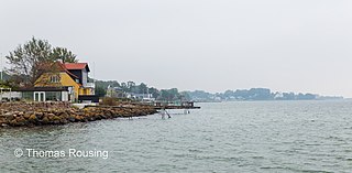
Taarbæk is a Copenhagen suburb. The village covers approximately 0.5 km2, located between Jægersborg Dyrehave and Øresund in the Lyngby-Taarbæk Municipality. The population is estimated to 1700 residents. Traditionally, Taarbæk was a fishing village but, nowadays, the village is inhabited by people from the middle or upper class. Taarbæk is named after a former village called Torsbæk, which was located just north of where Taarbæk is today. Despite its small size, Taarbæk has its own school, church, port, tennis club, water skiing club and football club. The water skiing club is among the best in Denmark. The football club Taarbæk IF, is one of the oldest football clubs in Denmark, founded on August 23, 1908.

Frieboeshvile is a Baroque-style country house in Kongens Lyngby north of Copenhagen, Denmark. It is located across the street from Sorgenfri Palace, where Lyngby Main Street meets Lyngby Kongevej. The house takes its name after Frederik Casper Conrad Frieboe who is buried in the grounds together with his wife and a few other family members. Its most notable former resident is Georg Ferdinand Duckwitz who played an important part in the Rescue of the Danish Jews during World War II.
Super Bikeways in metropolitan Copenhagen are a network of high quality bikeways under development to promote commuting by bicycle in metropolitan Copenhagen, Denmark. A collaboration between Copenhagen Municipality and 18 surrounding municipalities in Greater Copenhagen. The objective is to facilitate and increase commuting by bicycle.

Torvegade is the central thorughfare of Christianshavn in Copenhagen, Denmark, linking the city centre by way of Knippel Vridge with Amagerside Copenhagen at Christmas Møllers Plads. The street crosses Christianshavn Canal at Christianshavns Torv, the central square of the neighbourhood. The last section of the street runs on the embankment that across Stadsgraven.

Mølleåen, also Mølleå, sometimes translated as the Millstream, is a small river in North Zealand, Denmark, which runs 36 kilometres (22 mi) from the west of Bastrup Sø near Lynge to the Øresund between Taarbæk and Skodsborg. The valley contains several country houses and a series of mills which initiated Denmark's industrial development.

Fuglevad is a locality on the Mølleåen river in Lyngby-Taarbæk Municipality in the northern suburbs of Copenhagen, Denmark. Fuglevad Watermill, located approximately one kilometer downstream from Lyndby Nordre Mølle, has a history that dates back to the 15th century but the current buildings are from the 1870s. Fuglevad Windmill, a smock mill from 1832, is now located inside the grounds of the Frilandsmuseet open-air museu which opened at the site in 1901. Fuglevad Station is located on the Nærum Line and is served by the railway company Lokaltog.

Ørholm is a locality on the Mølleåen river in Lyngby-Taarbæk Municipality in the northern suburbs of Copenhagen9, Denmark. Ørholm Watermill has a history that dates back to at least the 15th century but the current industrial buildings were constructed after fires in 1886 and 1913. Ørholm House, a residence dating from the mid-18th century, is privately owned and heritage listed. Ørholm Station is located on the Nærum Railway and is served by the railway company Lokaltog.

Lundtofte Flyveplads is a former airport for both military and civilian use. Currently, the Technical University of Denmark is built on the site. The airport opened in 1917 and the last flight was in 1959.

Lyngby Søndre Mølle, literally Lyngby Southern Mill, is a defunct watermill on Mølleåen located at Lyngby Hovedgade, Kongens Lyngby, in the northern suburbs of Copenhagen, Denmark. The current building is from 1902. The name distinguishes it from nearby Lyngby Nordre Mølle.

Lyngby Lake is a lake located on the border between Lyngby-Taarbæk and Gladsaxe municipalities in the northern suburbs of Copenhagen, Denmark. It is the smallest of the four lakes that are located on Mølleåen. At the east end of the lake is an embankment with a lake promenade, S-train line and Lyngby Bypass. A small portion of the lake, known as Lille Ltngby Sø is located on the east side of the embankment.