In the United States, a metropolitan statistical area (MSA) is a geographical region with a relatively high population density at its core and close economic ties throughout the region. Such regions are not legally incorporated as a city or town would be and are not legal administrative divisions like counties or separate entities such as states. As a result, sometimes the precise definition of a given metropolitan area will vary between sources. The statistical criteria for a standard metropolitan area were defined in 1949 and redefined as a metropolitan statistical area in 1983.

The Blacksburg-Christiansburg Metropolitan Statistical Area, formerly the Blacksburg-Christiansburg-Radford Metropolitan Statistical Area, is a Metropolitan Statistical Area (MSA) as defined by the United States Office of Management and Budget (OMB) located in the New River Valley of Southwest Virginia. As of the 2020 census, the MSA had a population of 181,863.
Combined statistical area (CSA) is a United States Office of Management and Budget (OMB) term for a combination of adjacent metropolitan (MSA) and micropolitan statistical areas (μSA) across the 50 U.S. states and the territory of Puerto Rico that can demonstrate economic or social linkage. CSAs were first designated in 2003. OMB defines a CSA by various combinations of adjacent metropolitan and micropolitan areas with economic ties measured by commuting patterns. CSAs retain their own designations as metropolitan or micropolitan statistical areas in their respective larger combined statistical areas.

The Sarasota metropolitan area is a metropolitan area located in Southwest Florida. The metropolitan area is defined by the Office of Management and Budget (OMB) as the North Port–Bradenton–Sarasota Metropolitan Statistical Area, a metropolitan statistical area (MSA) consisting of Manatee County and Sarasota County. The principal cities listed by the OMB for the MSA are North Port, Bradenton, Sarasota, Lakewood Ranch, and Venice. At the 2020 census, the MSA had a population of 833,716. The Census Bureau estimates that its population was 910,108 in 2023.
The Commonwealth of Puerto Rico currently has 13 statistical areas that have been delineated by the United States Office of Management and Budget (OMB). On July 21, 2023, the OMB delineated three combined statistical areas, six metropolitan statistical areas, and four micropolitan statistical areas in Puerto Rico. As of 2023, the largest of these is the San Juan-Bayamón, PR CSA, comprising the area around the municipality of San Juan, the capital and largest city of Puerto Rico.

The Salisbury, MD Metropolitan Statistical Area is a United States Census Bureau–designated metropolitan area centered in and around Salisbury, Maryland, including two counties in Maryland: Somerset and Wicomico. Until 2023, the Salisbury MSA also included Worcester County.

The Manhattan–Junction City Combined Statistical Area, as defined by the United States Census Bureau, is an area consisting of three counties in northeastern Kansas, anchored by the city of Manhattan. It was upgraded from a Micropolitan Statistical Area (μSA) to a Metropolitan Statistical Area (MSA) by the Office of Management and Budget on November 20, 2008. It was changed from a Metropolitan Statistical Area (MSA) to a Combined Statistical Area (CSA) by the Office of Management and Budget on February 28, 2013.

The Cape Girardeau–Jackson Metropolitan Statistical Area, as defined by the United States Census Bureau, is an area consisting of two counties in southeastern Missouri and one in southern Illinois with its core in both states. Its largest cities are the cities of Cape Girardeau and Jackson. It was upgraded from a Micropolitan Statistical Area (μSA) to a Metropolitan Statistical Area (MSA) by the Office of Management and Budget on November 20, 2008.

The Paducah, KY–IL Metropolitan Statistical Area, as defined by the United States Census Bureau, is an area consisting of five counties – three in the Jackson Purchase region of Kentucky, a fourth Kentucky county bordering the Purchase, and one in Southern Illinois – anchored by the city of Paducah, Kentucky. The Paducah KY-IL Micropolitan Statistical Area was upgraded to Metropolitan Statistical Area (MSA) status on July 21, 2023, by the Office of Management and Budget.. Carlisle County, Kentucky, was added to the area following the 2020 Census of the Population. The total MSA population from the 2020 United States Census was 103,486.

The Dothan–Enterprise–Ozark Combined Statistical Area was a CSA made up of five counties in the southeastern corner of the U.S. state of Alabama. The once statistical area includes one metropolitan area and originally one micropolitan area which then was split off as two. As of the 2010 census, the CSA had a population of 245,838. Currently an updated area called the Dothan-Ozark Combined Statistical area is used instead and Enterprise micropolitan area is now split as its own statistical area.

The Aguadilla metropolitan area, is the third largest metropolitan statistical area (MSA) in Puerto Rico, comprising the municipalities of Aguadilla, Isabela, San Sebastián, Aguada, Moca, Añasco, and Rincón between the coastal plains, the Northern Karst Belt, and the Cordillera Central mountain subrange in the northwestern region of the main island. One of 6 metropolitan statistical areas in Puerto Rico, it lies within the Mayagüez–Aguadilla combined statistical area (CSA), which is one of 3 primary statistical areas in the main island as defined by the United States Census Bureau. As of 2023, census estimates place the population of the Aguadilla metropolitan area at 250,435.

The Guayama metropolitan area, is the smallest metropolitan statistical area (MSA) in Puerto Rico, comprising the municipalities of Guayama, Patillas, and Arroyo between the coastal plain and the Sierra de Cayey mountain subrange in the southeastern region of the main island. One of 6 metropolitan statistical areas in Puerto Rico, it lies within the San Juan–Bayamón combined statistical area (CSA), which is one of 3 primary statistical areas in the main island as defined by the United States Census Bureau. As of 2023, census estimates place the population of the Guayama metropolitan area at 65,190.
The Mayagüez metropolitan area, is the fourth largest metropolitan statistical area (MSA) in Puerto Rico, comprising the municipalities of Mayagüez, Cabo Rojo, San Germán, Lajas, Sabana Grande, and Hormigueros between the coastal plains and the Cordillera Central mountain subrange in the southwestern region of the main island. One of 6 metropolitan statistical areas in Puerto Rico, it lies within the Mayagüez–Aguadilla combined statistical area (CSA), which is one of 3 primary statistical areas in the main island as defined by the United States Census Bureau. As of 2023, census estimates place the population of the Mayagüez metropolitan area at 207,877.
The San Juan–Bayamón–Caguas metropolitan area, most commonly known as the San Juan metropolitan area, is the largest and most populous metropolitan statistical area (MSA) in Puerto Rico, concentrated in the capital municipality of San Juan and surrounding municipalities, including Bayamón, Caguas, and Carolina, on the northeastern coastal plain of the main island. One of 6 metropolitan statistical areas in Puerto Rico, it lies within the San Juan–Bayamón combined statistical area (CSA), which is one of 3 primary statistical areas in the main island as defined by the United States Census Bureau. As of 2023, census estimates place the population of the San Juan–Bayamón–Caguas metropolitan area at 2,035,733.
The Yauco Metropolitan Statistical Area was a United States Census Bureau defined metropolitan statistical area (MSA) in southwestern Puerto Rico. In 2023, this area was formally dissolved and three of its municipalities were added to the Ponce Metropolitan Statistical Area.
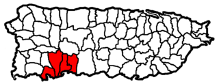
The San Germán–Cabo Rojo Metropolitan Statistical Area was a United States Census Bureau defined Metropolitan Statistical Area (MSA) in southwestern Puerto Rico. A July 1, 2009 Census Bureau estimate placed the population at 148,559, a 9.06% increase over the 2000 census figure of 136,212.
The Ponce metropolitan area, is the second largest metropolitan statistical area (MSA) in Puerto Rico, comprising the municipalities of Ponce, Juana Díaz, Yauco, Villalba, Peñuelas, Adjuntas, and Guayanilla between the coastal plain and the Cordillera Central mountain subrange in the south central region of the main island. One of 6 metropolitan statistical areas in Puerto Rico, it lies within the Ponce–Coamo combined statistical area (CSA), which is one of 3 primary statistical areas in the main island as defined by the United States Census Bureau. As of 2023, census estimates place the population of the Ponce metropolitan area at 266,237.
The Kokomo Metropolitan Statistical Area, as defined by the United States Census Bureau, is an area consisting of Howard County in Indiana. Howard County had a population estimate of 83,831 in 2023. Kokomo is also the principal city of the area known as North Central Indiana, the area around Kokomo with economic ties. The six county area including Cass, Clinton, Fulton, Howard, Miami, and Tipton counties had population of 228,331 people in 2010.
The United States federal government defines and delineates the nation's metropolitan areas for statistical purposes, using a set of standard statistical area definitions. As of 2023, the U.S. Office of Management and Budget (OMB) defined and delineated 393 metropolitan statistical areas (MSAs) and 542 micropolitan statistical areas (μSAs) in the United States and Puerto Rico. Many of these 935 MSAs and μSAs are, in turn, components of larger combined statistical areas (CSAs) consisting of adjacent MSAs and μSAs that are linked by commuting ties; as of 2023, 582 metropolitan and micropolitan areas are components of the 184 defined CSAs.
