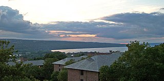
Cayuga Lake is the longest of central New York's glacial Finger Lakes, and is the second largest in surface area and second largest in volume. It is just under 39 miles (63 km) long. Its average width is 1.7 miles (2.8 km), and it is 3.5 mi wide (5.6 km) at its widest point, near Aurora. It is approximately 435 ft deep (133 m) at its deepest point, and has over 95 miles (153 km) of shoreline.

The Finger Lakes are a group of eleven long, narrow, roughly north–south lakes located directly south of Lake Ontario in an area called the Finger Lakes region in New York, in the United States. This region straddles the northern and transitional edge of the Northern Allegheny Plateau, known as the Finger Lakes Uplands and Gorges ecoregion, and the Ontario Lowlands ecoregion of the Great Lakes Lowlands.
Ithaca is a city in and the county seat of Tompkins County, New York, United States. Situated on the southern shore of Cayuga Lake in the Finger Lakes region of New York, Ithaca is the largest community in the Ithaca metropolitan statistical area. It is named after the Greek island of Ithaca. As of 2020, the city's population was 32,108.

Trumansburg is a village in Tompkins County, New York, United States. The population was 1,797 at the 2010 census. The name incorporates a misspelling of the surname of the founder, Abner Treman. The Tremans spelled their surname several different ways; "Truman," however, was not one of them. The village's application for a post office established the present spelling. The Village of Trumansburg is located within the Town of Ulysses and is northwest of Ithaca, New York.
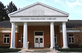
Ulysses is a town located in northwest Tompkins County, New York, U.S. The population was 4,940 at the 2020 census. The town was named after the hero of the Odyssey.
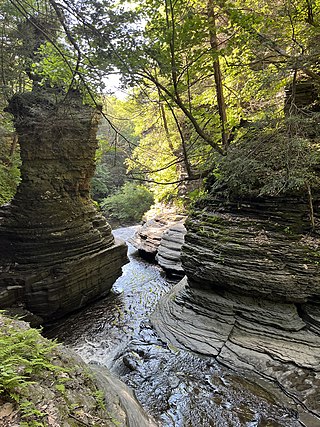
Buttermilk Falls State Park is a 811-acre (3.28 km2) state park located southwest of Ithaca, New York, United States. Like Robert H. Treman State Park, a portion of the land that was to become the state park came from Robert and Laura Treman in 1924.

The Seneca River flows 61.6 miles (99.1 km) through the Finger Lakes region of Upstate New York in the United States. The main tributary of the Oswego River – the second-largest river flowing into Lake Ontario – the Seneca drains 3,468 square miles (8,980 km2) in parts of fourteen New York counties. The Seneca flows generally east, and is wide and deep with a gentle gradient. Much of the river has been channelized to form part of the Erie Canal.

Taughannock Falls State Park is a 750-acre (3.0 km2) state park located in the town of Ulysses in Tompkins County, New York in the United States. The park is northwest of Ithaca near Trumansburg.

Robert H. Treman State Park is a 1,110-acre (4.5 km2) state park located in Tompkins County, in the Finger Lakes region of New York in the United States. The park is situated in the towns of Ithaca, Enfield and Newfield.
New York State Route 13 (NY 13) is a state highway that runs mainly north–south for 152.30 miles (245.10 km) between NY 14 in Horseheads and NY 3 west of Pulaski in Central New York in the United States. In between, NY 13 intersects with Interstate 81 (I-81) in Cortland and Pulaski and meets the New York State Thruway (I-90) in Canastota. NY 13 is co-signed with several routes along its routing, most notably NY 34 and NY 96 between Newfield and Ithaca; NY 80 between DeRuyter and Cazenovia; and NY 5 between Chittenango and Canastota.

Stewart Park is a municipal park operated by the City of Ithaca, New York on the southern end of Cayuga Lake, the largest of New York's Finger Lakes.
New York State Route 34 (NY 34) is a north–south New York state route located in Central New York. Its southern terminus is at the Pennsylvania state line in the village of Waverly, where it connects to Pennsylvania Route 199 and meets Interstate 86 (I-86). Its northern terminus is at NY 104, outside the village of Hannibal.
This is a list of trails in Ithaca, New York.

New York State Route 89 (NY 89) is a north–south state highway in central New York in the United States. It extends for 62.35 miles (100.34 km) from an intersection with NY 13, NY 34, and NY 96 in the Tompkins County city of Ithaca to an interchange with NY 104 in the Wayne County town of Wolcott. The route spans a total of three counties, connecting the heart of the Finger Lakes Region to a point 6 miles (10 km) south of Lake Ontario. Along the way, NY 89 intersects two regionally important highways: the conjoined routes of U.S. Route 20 (US 20) and NY 5 in Seneca Falls and NY 31 in Savannah. NY 89 runs along the western edge of Cayuga Lake from Ithaca to Seneca Falls.

Ithaca Falls is a waterfall located within the city of Ithaca, New York. It is the last of a series of waterfalls along the hanging valley formed where Fall Creek intersects the glacial trough of Cayuga Lake. The falls are in an amphitheater formed by freezing and thawing of the weak shale which makes up most of the gorge walls. The splash pool, and the creek just below the falls, are a popular spot for fly fishing.
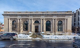
Ithaca is a town in Tompkins County, New York, United States. The town's population was 22,283 at the 2020 census. The town is in the central part of the county, in the Finger Lakes–Southern Tier region of New York, and is part of the Ithaca Metropolitan Statistical Area. The Town of Ithaca is a horseshoe-shaped portion of the metropolitan area of Ithaca, New York, surrounding the City of Ithaca and being the city's only border. Ithaca College is located in the South Hill section of the town.
Six Mile Creek is a 20-mile-long (32 km) creek in Tompkins County, New York. It originates in the Town of Dryden near the intersection of Irish Settlement Road and Card Road and drains into Cayuga Inlet, which flows into Cayuga Lake. Its watershed is the principal source of drinking water for the City of Ithaca, New York, and the surrounding communities.
Cayuga Medical Center, officially referred to as Cayuga Medical Center at Ithaca and abbreviated as CMC, is a not-for-profit general hospital in Ithaca, New York, serving the residents of Broome, Cayuga, Chemung, Cortland, Schuyler, Seneca, Tioga, and Tompkins counties. The hospital has 204 beds in total, and is one of the largest hospitals in the Finger Lakes region and the Southern Tier.
Indian Creek is a river located in Tompkins County, New York. It flows into Cayuga Lake northwest of Ithaca, New York.
Danby is the primary hamlet and a census-designated place (CDP) in the town of Danby, Tompkins County, New York, United States. It was first listed as a CDP prior to the 2020 census.


