Dover is a town and major ferry port in Kent, South East England. It faces France across the Strait of Dover, the narrowest part of the English Channel at 33 kilometres (21 mi) from Cap Gris Nez in France. It lies south-east of Canterbury and east of Maidstone. The town is the administrative centre of the Dover District and home of the Port of Dover.

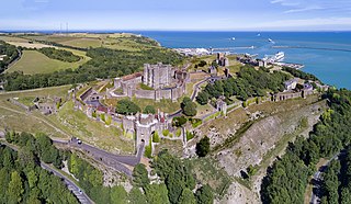
Dover Castle is a medieval castle in Dover, Kent, England and is Grade I listed. It was founded in the 11th century and has been described as the "Key to England" due to its defensive significance throughout history. Some writers say it is the largest castle in England, a title also claimed by Windsor Castle.

Down Street, also known as Down Street (Mayfair), is a disused station on the London Underground, located in Mayfair, west London. The Great Northern, Piccadilly and Brompton Railway opened it in 1907. It was latterly served by the Piccadilly line and was situated between Dover Street (now named Green Park) and Hyde Park Corner stations.

Kingsway telephone exchange was a Cold War-era hardened telephone exchange underneath High Holborn in London. Initially built as a deep-level air-raid shelter in the early 1940s, it was instead used as a government communications centre. In 1949 the General Post Office (GPO) took over the building, and in 1956 it became the UK termination point for TAT-1, the first transatlantic telephone cable. Closure of the facility began in the 1980s. It was built together with underground exchanges in Birmingham and Manchester, and was originally covered by a D notice

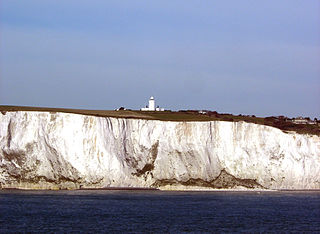
The White Cliffs of Dover are the region of English coastline facing the Strait of Dover and France. The cliff face, which reaches a height of 350 feet (110 m), owes its striking appearance to its composition of chalk accented by streaks of black flint, deposited during the Late Cretaceous. The cliffs, on both sides of the town of Dover in Kent, stretch for eight miles (13 km). The White Cliffs of Dover form part of the North Downs. A section of coastline encompassing the cliffs was purchased by the National Trust in 2016.

The Western Heights of Dover are one of the most impressive fortifications in Britain. They comprise a series of forts, strong points and ditches, designed to protect the country from invasion. They were created in the 18th and 19th centuries to augment the existing defences and protect the key port of Dover from both seaward and landward attack; by the start of the 20th century Dover Western Heights was collectively reputed to be the 'strongest and most elaborate' fortification in the country. The Army finally withdrew from the Heights in 1956–61; they are now a local nature reserve.

Fort Burgoyne, originally known as Castle Hill Fort, was built in the 1860s as one of the Palmerston forts around Dover in southeast England. It was built to a polygonal system with detached eastern and western redoubts, to guard the high ground northeast of the strategic port of Dover, just north of Dover Castle. The fort is named after the 19th century Field Marshal Sir John Fox Burgoyne, Inspector-General of Fortifications and son of the John Burgoyne who fought in the American Revolutionary War.

Hougham Battery is a World War II coastal defence battery built in 1941 between Dover and Folkestone in southeast England. It is on the cliff-edge between Abbot's Cliff and Shakespeare Cliff.

The Needles Batteries are two military batteries built above the Needles stacks to guard the West end of the Solent. The field of fire was from approximately West South West clockwise to Northeast and they were designed to defend against enemy ships.

Martin Mill railway station serves the small village of Martin Mill in East Kent. The station and all trains serving it are operated by Southeastern. The booking office is open only on weekday mornings however a ticket machine on the Dover-bound platform caters for out-of-hours ticketing. For many years the ticket office acted as a Post Office for the local community.

South Foreland is a chalk headland on the Kent coast of southeast England. It presents a bold cliff to the sea, and commands views over the Strait of Dover. It is centred 3 miles (4.8 km) northeast of Dover and 15 miles south of North Foreland. It includes the closest point on the Island of Britain to the European mainland at a distance of 20.6 miles (33.2 km).

Capel-le-Ferne is a village on the White Cliffs of Dover, near Folkestone in Kent, England. Its name derives from a medieval French term meaning "chapel in the ferns". In 2011 the village had a population of 1,884. It is perched on top of the White Cliffs of Dover.

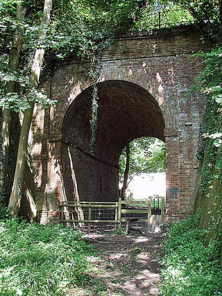
The Elham Valley Railway was a line connecting Folkestone and Canterbury in Kent, England. It opened between 1887 and 1889 and closed in 1947.

Langdon Bay is a bay in east Kent, England. It is two miles east of the town of Dover, and is named after the nearby villages of Langdon, East Langdon and West Langdon. The cliffs around it are known as the Langdon Cliffs. A prominent zig-zag path down the cliff-face is visible from the sea and connects with the National Trust path by means of a step ladder. An additional means of exit from the beach being a return on foot to St Margaret's Bay. At the far western end is a restricted area of the Port of Dover, and occasionally walkers will be escorted out by the Dover Port Police.

The Dover Strait coastal guns were long-range coastal artillery batteries that were sited on both sides of the English Channel during the Second World War. The British built several gun positions along the coast of Kent, England while the Germans fortified the Pas-de-Calais in occupied France. The Strait of Dover was strategically important because it is the narrowest part of the English channel. Batteries on both sides attacked shipping as well as bombarding the coastal towns and military installations. The German fortifications would be incorporated into the Atlantic Wall which was built between 1942 and 1944.

The BL 18-inch railway howitzer was a British railway gun developed during World War I. Part of the progression of ever-larger howitzers on the Western Front, it did not enter service until 1920.

The Tunnel Railway was a 2 ft narrow-gauge underground railway in Ramsgate, Kent, England. Following the restructuring of railway lines in Ramsgate in 1926, the section of line between Broadstairs and Ramsgate Harbour including a tunnel to the seafront at Ramsgate was abandoned. The narrow-gauge Tunnel Railway was opened within the disused tunnel in 1936 to connect tourist attractions and shops near Ramsgate harbour with the new railway main line at Dumpton Park.

Shakespeare Cliff Halt is a private halt station on the South Eastern Main Line. It is located to the western end of the dual-bore Shakespeare Cliff tunnel on the South Eastern Main Line to Folkestone, England. It never appeared in any public timetable and has been used successively by railway staff, coal miners, the military and Channel Tunnel workers.

Parson's Lodge Battery is a coastal battery and fort in the British Overseas Territory of Gibraltar.

Lord Airey's Battery is an artillery battery in the British Overseas Territory of Gibraltar. It is located near the southern end of the Upper Rock Nature Reserve, just north of O'Hara's Battery. It was named after the Governor of Gibraltar, General Sir Richard Airey. Construction of the battery was completed in 1891. The first gun mounted on the battery was a 6-inch breech loading gun, which was replaced with a 9.2-inch Mark X BL gun by 1900. The gun at the battery was last fired in the 1970s. In 1997, it was discovered that Lord Airey's Shelter, adjacent to Lord Airey's Battery, was the site chosen for a covert World War II operation that entailed construction of a cave complex in the Rock of Gibraltar, to serve as an observation post. The battery is listed with the Gibraltar Heritage Trust.


