
Rice County is a county located in the south central portion of the U.S. state of Minnesota. As of the 2020 census, the population was 67,097. Its county seat is Faribault.

Faribault County is a county in the U.S. state of Minnesota. As of the 2020 census, the population was 13,921. Its county seat is Blue Earth.

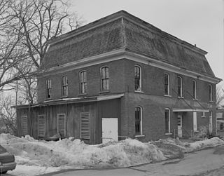
Faribault is a city in, and the county seat of, Rice County, Minnesota, United States. The population was 23,352 at the 2010 census. Faribault is approximately 50 miles (80 km) south of Minneapolis–Saint Paul.

Nerstrand is a city in Rice County, Minnesota, United States.

Route 139 is a state highway in Jersey City, New Jersey in the United States that heads east from the Pulaski Skyway over Tonnele Circle to the state line with New Jersey and New York in the Holland Tunnel, which is under the Hudson River, to New York City. The western portion of the route is a two level highway that is charted by the New Jersey Department of Transportation (NJDOT) as two separate roadways: The 1.45-mile (2.33 km) lower roadway (Route 139) between U.S. Route 1/9 (US 1/9) over Tonnele Circle and Interstate 78 (I-78) at Jersey Avenue, and the 0.83-mile (1.34 km) upper roadway running from County Route 501 and ending where it joins the lower highway as part of the 12th Street Viaduct, which ends at Jersey Avenue. The lower roadway is listed on the federal and NJ state registers of historic places since 2005. The eastern 1.32 miles (2.12 km) of the route includes the Holland Tunnel approach that runs concurrent with Interstate 78 on the one-way pair of 12th Street eastbound and 14th Street westbound. Including the concurrency, the total length of Route 139 is 2.77 miles (4.46 km).

The Historic Columbia River Highway is an approximately 75-mile-long (121 km) scenic highway in the U.S. state of Oregon between Troutdale and The Dalles, built through the Columbia River Gorge between 1913 and 1922. As the first planned scenic roadway in the United States, it has been recognized in numerous ways, including being listed on the National Register of Historic Places, being designated as a National Historic Landmark by the U.S. Secretary of the Interior, being designated as a National Historic Civil Engineering Landmark by the American Society of Civil Engineers, and being considered a "destination unto itself" as an All-American Road by the U.S. Secretary of Transportation. The historic roadway was bypassed by the present Columbia River Highway No. 2 from the 1930s to the 1950s, leaving behind the old two-lane road. The road is now mostly owned and maintained by the state through the Oregon Department of Transportation as the Historic Columbia River Highway No. 100 or the Oregon Parks and Recreation Department as the Historic Columbia River Highway State Trail.

The Thomas Viaduct spans the Patapsco River and Patapsco Valley between Relay, Maryland and Elkridge, Maryland, USA. It was commissioned by the Baltimore and Ohio Railroad (B&O); built between July 4, 1833, and July 4, 1835; and named for Philip E. Thomas, the company's first president. Some claim it to be the world's oldest multiple arched stone railroad bridge. However, the Sankey Viaduct on the Liverpool and Manchester Railway was opened in 1830, and finally completed in 1833.
The Nebraska Department of Transportation (NDOT) is the state government agency charged with building and maintaining the state highways in the U.S. state of Nebraska, as well as the state's airports. The main headquarters of the agency is located in Lincoln, the capital city. There are currently eight NDOT district offices located across the state.

The Walnut Street Bridge is a historic Pratt through truss bridge over the North Fork of the Zumbro River in Mazeppa, Minnesota, United States. It was built as a highway bridge in 1904 but has been restricted to pedestrian use since 1980. It was listed on the National Register of Historic Places in 2003 for having local significance in the theme of engineering. It was nominated for being the work of noted Minnesota engineer William S. Hewett and his bridge building firm the W. S. Hewett Co., an example further recognized for its exceptional ornamentation.

The Zumbro Parkway Bridge is a historic arch bridge with two 25-foot (7.6 m) spans over a tributary of the Zumbro River just outside the city of Zumbro Falls in Hyde Park Township, Minnesota, United States. It was constructed in 1937 by the Works Progress Administration using a modular corrugated iron product known as Multi Plate, and given a masonry veneer with Gothic Revival details. The bridge was listed on the National Register of Historic Places in 1989 for having state-level significance in the theme of engineering. It was nominated for being one of Minnesota's finest examples of a stone-faced Multi Plate arch highway bridge, a style used in many of the state's New Deal bridge projects.

Bridge 5827 is a historic arch bridge in Zumbro Falls, Minnesota, United States, built in 1938 by the Works Progress Administration using a modular corrugated iron product called Multi Plate. It was listed on the National Register of Historic Places as the Bridge No. 5827–Zumbro Falls in 1998 for having state-level significance in the theme of engineering. It was nominated as an example of Minnesota's stone-faced Multi Plate bridges with particularly fine masonry.

The Alexander Faribault House is a historic house museum in Faribault, Minnesota, United States. Built in 1853, it was the first wood-frame house constructed in Rice County, Minnesota. It was built by fur trader Alexander Faribault in the Greek Revival style. Besides serving as a house, it also served as a civic center, polling place, and a church. The local address of the house is 12 First Avenue, Faribault, MN. The house was listed on the National Register of Historic Places in 1970.
Blind Department Building and Dow Hall, State School for the Blind were two buildings that were part of the Minnesota State Academy for the Blind, a public school administered by the state in Faribault, Minnesota, United States. The two structures, Dow Hall and the Blind Department Building, were significant components of a system of state-administered special education for the physically and mentally disabled segments of the population. Both buildings have been demolished, and their listing was removed from the National Register of Historic Places in 2016.
This is a list of the National Register of Historic Places listings in Rice County, Minnesota. It is intended to be a complete list of the properties and districts on the National Register of Historic Places in Rice County, Minnesota, United States. The locations of National Register properties and districts for which the latitude and longitude coordinates are included below, may be seen in an online map.

The Fort Street–Pleasant Street and Norfolk & Western Railroad Viaduct is a bridge carrying six lanes of Fort Street over both Pleasant Street and multiple tracks comprising the Norfolk Southern Railway Detroit District and Conrail Shared Assets Lincoln Secondary and Junction Yard Secondary lines on the border of the Boynton and Oakwood Heights neighborhoods in Detroit, Michigan, just west of the Rouge River. It was listed on the National Register of Historic Places in 2000. The bridge underwent massive repairs and other construction in late 2010 and throughout much of 2011, which included narrowing the Fort Street boulevard north of the viaduct into a six-lane undivided road with a left-turns-only lane. The bridge was removed from the NRHP in 2022.

The Gateway Trail Iron Bridge is a historic camelback truss bridge on the Gateway State Trail in Grant, Minnesota, United States. The bridge has stood in three locations in Minnesota. Its main span was built of wrought iron in 1873—before steel became the preferred material for metal bridges—and erected in Sauk Centre in Central Minnesota. Designated Bridge No. 5721, it was refurbished and moved in 1937 to rural Koochiching County in northern Minnesota, where it became known as the Silverdale Bridge. It was relocated to its present site in east-central Minnesota in 2011 and renamed Bridge No. 82524. It was listed on the National Register of Historic Places in 1998 for its state-level significance in engineering. It was nominated as a rare example of a wrought iron truss bridge with ornamental detailing.

The Straight Street Bridge is a vehicular bridge over the Passaic River in Paterson, New Jersey, that is listed on the National Register of Historic Places.

Arch Street Bridge is Parker truss bridge over the Passaic River in Paterson, New Jersey. It was built in 1907 and rehabilitated in 1997. It was the third structure built at the location within a few years, the other having been destroyed by floods in 1902 and 1903. The bridge was once a crossing for the Public Service trolley lines.

Camp Ripley Bridge, also known as Bridge 4969, is the only remaining unified road–rail bridge over the Mississippi River. It carries both a railroad spur line and Minnesota State Highway 115 at Camp Ripley in Morrison County.


