Faro Point

Last updated
Capo Peloro with its lighthouse and its fort Torre Faro lighthouse - Capo Peloro - Messina, Italy - 20 Oct. 2010.jpg
Capo Peloro with its lighthouse and its fort

Faro Point (Italian : Punta del Faro) or Peloro Cape (Italian: Capo Peloro; Sicilian : Capu Piloru) [lower-alpha 1] is the northeastern promontory of Sicily situated in Messina district at northeast of the city.

Contents

The village is connected to the city center by two ATM bus lines: line 32 (Ponte Gallo–Mortelle–Terminal Museo) and shuttle line 1 (Giampilieri SuperioreTorre Faro). [1]

Historical significance

As the ancient Pelorus, Punta del Faro is one of the most celebrated promontories of Sicily, forming the northeastern extremity of the whole island, and one of the three promontories which were considered to give to it the triangular form from which it derived the name of Trinacria. [2] It was at the same time the point which projected farthest towards the opposite coast of Italy; so that the narrowest part of the Sicilian straits was that which lay between Cape Pelorus and the coast adjoining the headland of Caenys (It. Cenide, modern Punta del Pezzo) on the coast of Bruttium (modern Calabria), therefore the nearest points of the Strait of Messina. [3]

A strange story is told by some Roman writers that it derived its ancient name from the pilot of Hannibal, who was put to death by that general from a suspicion of treachery; thus overlooking the fact that it was known by that name to the Greeks for centuries before the time of Hannibal. [4] The actual headland of Pelorus, now called the Capo del Faro, is a low, sandy point; but about 3 km from its extremity there begins a ridge of hills which quickly rises into a range of mountains, of no great elevation, but steep and strongly marked. These continue in an unbroken range at the back of Messina, near which they attain a height of about 1000 m, and flank the east coast of the island as far as the neighborhood of Taormina, where they turn abruptly to the west and stretch across in that direction without any real interruption, until they join the more lofty group of the Monte Madonia. It is to this range of mountains that the name of "Mons Neptunius" is applied by Solinus called today mounts Peloritani, [5] and which that author describes as separating the Tyrrhenian and Adriatic (i. e. Sicilian) seas. But there is no real geographical line of separation between these mountains and those farther west, which were known to the ancients as the "Mons Nebrodes".

The headland of Pelorus may thus be looked upon as the extremity of a great mountain promontory, formed by the range of the Mons Neptunius, and extending from the neighbourhood of Messina to that of Milazzo (ancient Mylae), or, in a still wider sense, from Taormina (ancient Tauromenium) on the east coast to Tindari (ancient Tyndaris) on the north. Diodorus calls it 100 stadia from the promontory to Messana, and the distance is still commonly reckoned near 20 km, though it does not really exceed 13 km. (Diod. xiv. 56.)

From its proximity to Messana and its position commanding the passage of the straits, Pelorus was an important naval station, and as such its name is frequently mentioned in history. Thus, in 425 BCE, when the Athenian fleet under Laches was established at Rhegium (modern Reggio di Calabria), the Syracusans and their allies took post with their fleet at Pelorus, where they were supported also by a land force. [6] In 396 BCE the Carthaginian general Himilco took post at Pelorus with his fleet and army, and, when the Messanians sallied out to attack him, by taking advantage of a north wind, sent his fleet down suddenly to Messana, which was surprised and taken before the troops could return to its defence. [7] Again, during the siege of Messana by the Carthaginians: at the commencement of the First Punic War; it was at Pelorus that their fleet was stationed, with the view both of threatening the city and preventing the Romans from crossing the straits. [8] And at a later period, during the contest between Octavian and Sextus Pompey in the neighborhood of Messana, the headland of Pelorus once more became an important post, being one of the points sedulously guarded by Pompey in order to prevent his adversary from effecting a landing. [9]

The actual promontory of Pelorus, as already mentioned, is a low spit or point of sand, about 3 km in length, which has evidently been thrown up by the currents, which flow with great rapidity through the straits. [10] A tradition, reported by Diodorus, but as ancient as the time of Hesiod, represented it as an artificial work constructed by the giant Orion. [11] Within this sandy point, between the beach and the hills, are enclosed two small lakes or pools which are famous for producing the best eels and cockles in Sicily, [12] a reputation they already enjoyed in ancient times, as the cockles of Pelorus are repeatedly noticed by Athenaeus; and Solinus, who mentions the lakes in question, speaks of them as abounding in fish. There appear to have been three of them in his day, but the marvels which he relates of one of them are purely fabulous. [13] A temple of Neptune stood in ancient times upon the promontory, as well as a lighthouse or Pharos, the memory of which is retained in the modern name of Punta del Faro, by which the cape is still known. This appellation seems to have indeed come into use before the close of the Roman Empire, as Servius, in describing the width of the Sicilian strait, measures it a Columna usque ad Pharon. [14] But no remains of either building are now visible.

Capo Peloro 2021 Capu Piloru.jpg
Capo Peloro 2021

See also

Notes

  1. Ancient Greek: Πέλωρος ἄκρα, romanized: Pélōros ákrā (Ptolemy), ΠελωρίςPelōrís (Thucydides, Dion. Per.), or ΠελωριάςPelōriás (Polybius, Strabo); Latin: Pelorus, Peloris, or Pelorias.

Related Research Articles

<span class="mw-page-title-main">Sicily</span> Island in the Mediterranean, region of Italy

Sicily is the largest and most populous island in the Mediterranean Sea and one of the 20 regions of Italy. The Strait of Messina divides it from the region of Calabria in Southern Italy. It is one of the five Italian autonomous regions and is officially referred to as Regione Siciliana. The region has 5 million inhabitants. Its capital city is Palermo.

<span class="mw-page-title-main">Tindari</span> Frazione of Italy

Tindari, ancient Tyndaris or Tyndarion, is a small town, frazione in the comune of Patti and a Latin Catholic titular see.

<span class="mw-page-title-main">Messina</span> Comune in Sicily, Italy

Messina is a harbour city and the capital of the Italian Metropolitan City of Messina. It is the third largest city on the island of Sicily, and the 13th largest city in Italy, with a population of more than 219,000 inhabitants in the city proper and about 650,000 in the Metropolitan City. It is located near the northeast corner of Sicily, at the Strait of Messina and it is an important access terminal to Calabria region, Villa San Giovanni, Reggio Calabria on the mainland. According to Eurostat the FUA of the metropolitan area of Messina has, in 2014, 277,584 inhabitants.

<span class="mw-page-title-main">Taormina</span> Comune in Sicily, Italy

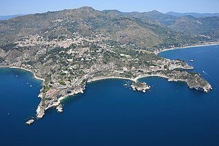
Taormina is a comune (municipality) in the Metropolitan City of Messina, on the east coast of the island of Sicily, Italy. Taormina has been a tourist destination since the 19th century. Its beaches on the Ionian sea, including that of Isola Bella, are accessible via an aerial tramway built in 1992, and via highways from Messina in the north and Catania in the south. On 26–27 May 2017 Taormina hosted the 43rd G7 summit.

<span class="mw-page-title-main">Strait of Messina Bridge</span> Proposed suspension bridge in Italy

The Strait of Messina Bridge was a proposal to build a suspension bridge across the Strait of Messina in Italy to connect the cities of Torre Faro and Villa San Giovanni.

<span class="mw-page-title-main">Battle of Malta</span> 1283 battle part of the War of the Sicilian Vespers

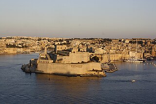
The Battle of Malta took place on 8 July 1283 in the entrance to the Grand Harbour, the principal harbour of Malta, as part of the War of the Sicilian Vespers. An Aragonese fleet of galleys, commanded by Roger of Lauria, attacked and defeated a fleet of Angevin galleys commanded by Guillaume Cornut and Bartholomé Bonvin.

<span class="mw-page-title-main">Halaesa</span>

Halaesa, also known as Halaesa Archonidea and also spelled Alaesa or Halesa was an ancient city of Sicily, situated near the north coast of the island, between Cephaloedium and Calacte.

<span class="mw-page-title-main">Naxos (Sicily)</span> Ancient Greek city state in Sicily

Naxos or Naxus was an ancient Greek city, presently situated in modern Giardini Naxos near Taormina on the east coast of Sicily.

<span class="mw-page-title-main">Flag of Sicily</span> Flag of the Italian region of Sicily

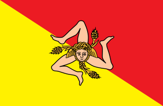
The flag of Sicily shows a triskeles symbol, and at its center a Gorgoneion and a pair of wings and three wheat ears.

<span class="mw-page-title-main">Salso</span> River in Sicily

The Salso, also known as the Imera Meridionale, is a river of Sicily. It rises in the Madonie Mountains and, traversing the provinces of Enna and Caltanissetta, flows into the Mediterranean at the western end of the Gulf of Gela at the seaport of Licata, in the Province of Agrigento. Its small deltaic system there is dominated by marine processes rather than fluvial ones. It is a seasonal torrent, with brief but violent floods during the winter rains, and all but dry in summer droughts. In November 1915 the iron bridge across the river's mouth collapsed during floods, and 119 people were swept away in the flood and lost. The Salso, which is the longest river of Sicily at 132 kilometres (82 mi), has a drainage basin area of 2,022 square kilometres (781 sq mi).

Scyllaeum was a promontory, and ancient town or fortress, on the west coast of Bruttium, about 25 km north of Rhegium, and almost exactly at the entrance of the Sicilian strait.

<span class="mw-page-title-main">Eryx (Sicily)</span>

Eryx was an ancient city and a mountain in the west of Sicily, about 10 km from Drepana, and 3 km from the sea-coast. It was located at the site of modern Erice.

<span class="mw-page-title-main">Naulochus</span> Ancient city in Sicily

Naulochus, Naulochos, Naulochoi, or Naulocha, was an ancient city on the north coast of Sicily, between Mylae and Cape Pelorus. It is known primarily from the great sea-fight in which Sextus Pompeius was defeated by Marcus Vipsanius Agrippa, 36 BCE, and which was fought between Mylae and Naulochus. Pompeius himself during the battle had been encamped with his land forces at Naulochus, and after his victory, Octavian, in his turn, took up his station there, while Agrippa and Lepidus advanced to attack Messana. It is clear from its name that Naulochus was a place where there was a good roadstead or anchorage for shipping. Some have doubted its existence as a populated place, but Silius Italicus includes it in his list of Sicilian cities. From the description in Appian it is clear that it was situated between Mylae and Cape Rasoculmo, and probably not very far from the latter point; but there is nothing to fix its site more definitely. The editors of the Barrington Atlas of the Greek and Roman World place it near the modern comune of Spadafora.

<span class="mw-page-title-main">Capo Passero</span> Place

Capo Passero or Cape Passaro is a celebrated promontory of Sicily, forming the extreme southeastern point of the whole island, and one of the three promontories which were supposed to have given to it the name of "Trinacria."

The Battle of Messene took place in 397 BC in Sicily. Carthage, in retaliation for the attack on Motya by Dionysius, had sent an army under Himilco, to Sicily to regain lost territory. Himilco sailed to Panormus, and from there again sailed and marched along the northern coast of Sicily to Cape Pelorum, 12 miles (19 km) north of Messene. While the Messenian army marched out to offer battle, Himilco sent 200 ships filled with soldiers to the city itself, which was stormed and the citizens were forced to disperse to forts in the countryside. Himilco later sacked and leveled the city, which was again rebuilt after the war.

<span class="mw-page-title-main">Battle of Catana (397 BC)</span> Naval battle of the Sicilian War

The Battle of Catana took place in the summer of 397 BC. The Greek fleet under Leptines, the brother of Dionysius I of Syracuse, engaged the Carthaginian fleet under Mago near the city of Catana in Sicily. While the Greek army under Dionysius was present near the city of Catana during the battle, the Carthaginian army under Himilco was away in the interior of Sicily, making a detour around the erupting Mount Etna. The Carthaginian fleet crushed the Greek fleet in the battle, leading to the Carthaginian siege of Syracuse later in 397 BC.

The Battle of Abacaenum took place between the Carthaginian forces under Mago and the Greek army under Dionysius in 393 BC near the Sicilian town on Abacaenum in north-eastern Sicily. Dionysius, tyrant of Syracuse, had been expanding his influence over Sicels' territories in Sicily. After Dionysius' unsuccessful siege in 394 BC of Tauromenium, a Carthaginian ally, Mago decided to attack Messana. However, the Carthaginian army was defeated by the Greeks near the town of Abacaenum and had to retire to the Carthaginian territories in Western Sicily. Dionysius did not attack the Carthaginians but continued to expand his influence in eastern Sicily.

<span class="mw-page-title-main">Capo Peloro Lighthouse</span> Lighthouse

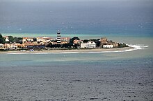
Capo Peloro Lighthouse is an active lighthouse located in Punta del Faro on the Strait of Messina, the most north-eastern promontory of Sicily, settled in the Province of Messina, the place closest to Calabria.

<span class="mw-page-title-main">History of Taormina</span>

Taormina dates to around 396 BC after Dionysius I of Syracuse destroyed nearby Naxos in 403 BC and the Siculi formed a new settlement on the nearby Mount Taurus which gradually grew up into the city of Tauromenium.

<span class="mw-page-title-main">Torre Faro</span> Italian seaside village

Torre Faro is a frazione of the comune of Messina in the Province of Messina, Sicily, southern Italy. It is a seaside village near the Ganzirri Lake and on its territory it hosts the Pylons of Messina.

References

  1. "Linea 32 Ponte Gallo-Mortelle-Terminal Museo". atmmessinaspa.it (in Italian). 2 November 2020.
  2. Pol. i. 42; Strab. vi. pp. 265-66; Diod. v. 2; Plin. iii. 8. s. 14; Dion. Per. 467-72; Ovid Met. xiii. 727.
  3. "Faropoint" . Retrieved 2021-09-14.
  4. Mela ii. 7. § 17; Valerius Maximus ix. 8. § 1; Sallust, ap. Serv. ad Aen. iii. 411.
  5. 5 . § 12.
  6. Thucydides iv. 25.
  7. Diod. xiv. 56, 57.
  8. Pol. i. 11.
  9. Appian, B.C. v. 105, 116.
  10. Symth's Sicily, p. 109.
  11. Diod. iv. 85.
  12. William Henry Smyth, l. c. p. 106.
  13. Athen. i. p. 4. c., iii. p. 92. f.; Gaius Julius Solinus 5. §§ 2-4.
  14. Servius ad Aeneidos iii. 411.