Harstad (Norwegian) or Hárstták (Northern Sami) is the second-most populated municipality in Troms county, Norway. It is mostly located on the large island of Hinnøya. The municipal center is the town of Harstad, the most populous town in Central Hålogaland, and the third-largest in all of Northern Norway. The town was incorporated in 1904. Villages in the municipality include Elgsnes, Fauskevåg, Gausvik, Grøtavær, Kasfjord, Lundenes, Nergården and Sørvika.

Skånland is a municipality in Troms county, Norway. It is part of the Central Hålogaland region, just southeast of the city of Harstad. The administrative centre of the municipality is the village of Evenskjer. Other villages include Grovfjord, Renså, Sandstrand, and Tovik.

Stonglandseidet is a village in Tranøy Municipality in Troms county, Norway. The village has a population (2001) of 225. The village is home to a grocery store, bank, nursing home, Stonglandet Church, and a public school.
Kasfjord is a village in Harstad Municipality in Troms county, Norway. The village is located at the end of the Kasfjorden on the north side of Hinnøya island, about 10 kilometres (6.2 mi) west of the town of Harstad and about 12 kilometres (7.5 mi) south of the village of Elgsnes. The Kasfjordvannet lake is located along the east side of the village. The 0.34-square-kilometre (84-acre) village has a population (2011) of 252. The population density is 741 inhabitants per square kilometre (1,920/sq mi).
Tovik is a village in Skånland Municipality in Troms county, Norway. The village is located on the mainland at the entrance of the two fjords; Astafjorden and Vågsfjorden, and at a distance of about 35 kilometres (22 mi) from Harstad/Narvik Airport, Evenes. Tovik's population (2001) is 151.
Kilbotn is a village in Harstad Municipality in Troms county, Norway. The village is located about 12 km (7.5 mi) south of the center of the town of Harstad, along the Vågsfjorden on the east side of Hinnøya island. The villages of Fauskevåg and Sørvika are just a few kilometres to the south of Kilbotn. The population (2001) of the village is 332, but since 2002 it has been considered a part of the Harstad urban area.
Å is a village in Ibestad Municipality in Troms county, Norway. It is located about 26 kilometres (16 mi) east of the town of Harstad on the southwest side of the island of Andørja, along the Bygda strait which goes between the Vågsfjorden and the Astafjorden. The village of Å and the neighboring villages of Laupstad and Ånstad altogether have a total population (2001) of 205 residents.

Å is a village in Lavangen Municipality in Troms county, Norway. The village is located along the northern shore of the Lavangen fjord, about 4 kilometres (2.5 mi) north of the administrative centre of Tennevoll and about 52 kilometres (32 mi) east of the town of Harstad.
Å is a village in Tranøy Municipality in Troms county, Norway. The village is home to 132 residents (2001). The village is about 36 kilometres (22 mi) across the Vågsfjorden from the city of Harstad. There is a daycare in Å, but the school, church, and stores are located 8 km (5.0 mi) to the east in the neighboring village of Stonglandseidet.
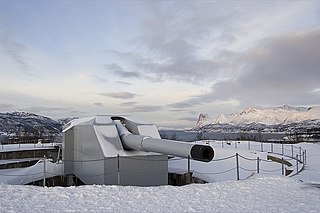
Trondenes Fort is a fort situated on the Trondenes peninsula in the municipality of Harstad in Troms county, Norway. It is located about 2.5 kilometres (1.6 mi) north of the town of Harstad. The fort has been the main base for the Norwegian Coastal Ranger Command since 2002. The fort was built in 1943 by the Nazis occupying Norway during World War II as a part of the Atlantic Wall.

Sandtorg is a village in Harstad Municipality in Troms county, Norway. It is located on the eastern shore of the large island of Hinnøya, on the shore of the Tjeldsundet. The village is located along the European route E10 highway in the southern part of the municipality. There are about 300 residents in the village area. The 1,095-metre (3,593 ft) tall mountain Sætertinden is located northwest of the village of Sandtorg, along the border with Tjeldsund municipality.

Sørvik or Sørvika is a village in Harstad Municipality in Troms county, Norway. It is located along the Vågsfjorden on the island of Hinnøya about 17 kilometres (11 mi) south of the town of Harstad
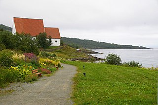
Trondenes is an old parish and former municipality in Troms county in Norway. The 186-square-kilometre (72 sq mi) municipality existed from 1838 until its dissolution in 1964. It was located along the western shore of the Vågsfjorden in what is now Harstad Municipality. Trondenes included the majority of the island of Grytøya and part of the eastern coast of the island of Hinnøya as well as some smaller islands. Located just north of the town of Harstad, the village of Trondenes was the administrative centre of the municipality. That village is also the site of the historic Trondenes Church, the northernmost medieval stone church in Norway. The Trondenes Historical Center was built in 1997 near the church to teach about the history of the area. Trondenes Fort is also located on the Trondenes peninsula.
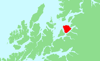
Harstad is a town in Harstad Municipality in Troms county, Norway. The town is also the administrative centre of the municipality of Harstad. The 11.15-square-kilometre (2,760-acre) town has a population (2017) of 20,953 which gives the town a population density of 1,879 inhabitants per square kilometre (4,870/sq mi). It is the second-largest town in Troms county, after the city of Tromsø, and it is the largest town in Central Hålogaland.
Lundenes is a village in Harstad Municipality in Troms county, Norway. It is located on the eastern part of the island of Grytøya, along the Vågsfjorden, about 10 kilometres (6.2 mi) north of the town of Harstad. Lundenes Church is located in the village.
Grøtavær is a coastal fishing village in Harstad Municipality in Troms county, Norway. It is located on the western part of the island of Grytøya, along the Andfjorden, about 16 kilometres (9.9 mi) northwest of the village of Lundenes. Grøtavær Church is located in the village and the Grøtavær islands are located just off shore.
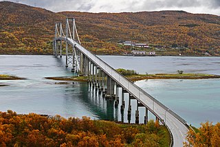
Gausvik or Gausvika is a village in Harstad Municipality in Troms county, Norway. It is located on the northeastern part of the large island of Hinnøya, along the Tjeldsundet strait, about 25 kilometres (16 mi) south of the town of Harstad. The European route E10 highway passes through the village, about 3 kilometres (1.9 mi) south of the Tjeldsund Bridge. Gausvik Church is located in this village.
Andørja (Norwegian) or Áttir (Northern Sami) is an island in Ibestad Municipality in Troms county, Norway. The 135-square-kilometre (52 sq mi) island lies about 25 kilometres (16 mi) east of the town of Harstad. The island is located entirely within the present-day municipality of Ibestad, although the island itself was a separate municipality (Andørja) from 1926 until 1964. The largest population area on Andørja island is the Å - Ånstad - Laupstad area on the west coast with 205 residents (2001). Andørja Church is located in Engenes on the northwestern tip of the island.
Sandtorg is a former municipality in Troms county, Norway. The 177-square-kilometre (68 sq mi) municipality existed from 1926 until its dissolution in 1964. The municipality included the southern part of what is now Harstad Municipality on the eastern coast of the island of Hinnøya as well as some smaller islands in the Vågsfjorden. The administrative centre was actually located in the town of Harstad, immediately north of Sandtorg. Sandtorg Church, the main church for the municipality was in the village of Sørvika.