The Cherokee People are one of the Indigenous peoples of the Southeastern Woodlands of the United States. Prior to the 18th century, they were concentrated in their homelands, in towns along river valleys of what is now southwestern North Carolina, southeastern Tennessee, southwestern Virginia, edges of western South Carolina, northern Georgia and northeastern Alabama consisting of around 40,000 square miles
The Trail of Tears was the forced displacement of approximately 60,000 people of the "Five Civilized Tribes" between 1830 and 1850, and the additional thousands of Native Americans within that were ethnically cleansed by the United States government.
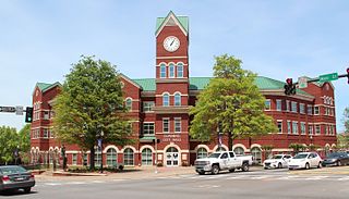
Cumming is a city in Forsyth County, Georgia, United States, and the sole incorporated area in the county. It is a suburban city, and part of the Atlanta metropolitan area. In the 2020 census, the population is 7,318, up from 5,430 in 2010. Surrounding unincorporated areas with a Cumming mailing address have a population of approximately 100,000. Cumming is the county seat of Forsyth County.

Major Ridge, The Ridge was a Cherokee leader, a member of the tribal council, and a lawmaker. As a warrior, he fought in the Cherokee–American wars against American frontiersmen. Later, Major Ridge led the Cherokee in alliances with General Andrew Jackson and the United States in the Creek and Seminole wars of the early 19th century.

The Treaty of New Echota was a treaty signed on December 29, 1835, in New Echota, Georgia, by officials of the United States government and representatives of a minority Cherokee political faction, the Treaty Party.
Historic ferries operated on rivers around Atlanta, Georgia area, and became namesakes for numerous current-day roads in north Georgia. Most of the ferries date to the early years of European-American settlement in the 1820s and 1830s, when parts of the region were still occupied by cherokee and other Native American communities.

New Echota was the capital of the Cherokee Nation in the Southeastern United States from 1825 until their forced removal in the late 1830s. New Echota is located in present-day Gordon County, in northwest Georgia, north of Calhoun. It is south of Resaca, next to present day New Town, known to the Cherokee as Ꭴꮝꮤꮎꮅ, Ustanali. The site has been preserved as a state park and a historic site. It was designated in 1973 as a National Historic Landmark District.

John Ridge, born Skah-tle-loh-skee, was from a prominent family of the Cherokee Nation that had a lot of status, then located in present-day Georgia. He went to Cornwall, Connecticut, to study at the Foreign Mission School And was very educated. He met Sarah Bird Northup, of a New England Yankee family, and they married in 1824. Soon after their return to New Echota in 1825, Ridge was chosen for the Cherokee National Council and became a leader in the tribe.

The Chief Vann House is the first brick residence in the Cherokee Nation, and has been called the "Showplace of the Cherokee Nation". Owned by the Cherokee Chief James Vann, the Vann House is a Georgia Historic Site on the National Register of Historic Places and one of the oldest remaining structures in the northern third of the state of Georgia. It is located in Murray County, on the outskirts of Chatsworth in northwest Georgia, which has a commanding view of the land around it and of the Cohutta Mountains, about 10 miles (16 km) to the east.
James Vann was an influential Cherokee leader, one of the triumvirate with Major Ridge and Charles R. Hicks, who led the Upper Towns of East Tennessee and North Georgia as part of the ᎤᏪᏘ ᏣᎳᎩ ᎠᏰᎵ. He was the son of ᏩᎵ (Wali) Vann and Indian trader Joseph John Vann. He was born into his mother's Clan, ᎠᏂᎪᏓᎨᏫ.

The Georgia land lotteries were an early nineteenth century system of land redistribution in Georgia. Under this system, various categories of persons could register for a chance to win lots of land that had been appropriated by the State of Georgia or the Federal government from the Muscogee and the Cherokee Nation. The lottery system was utilized by the State of Georgia between the years 1805 and 1833 “to strengthen the state and increase the population in order to increase Georgia's power in the House of Representatives.” Although some other states used land lotteries, none were implemented at the scale of the Georgia contests.

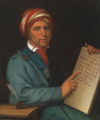
Samuel Austin Worcester, was an American missionary to the Cherokee, translator of the Bible, printer, and defender of the Cherokee sovereignty. He collaborated with Elias Boudinot (Cherokee) in Georgia to establish the Cherokee Phoenix, the first Native American newspaper, which was printed in both English and the Cherokee syllabary. The Cherokee gave Worcester the honorary name A-tse-nu-sti, which translates to "messenger" in English.

Red Clay State Historic Park is a state park located in southern Bradley County, Tennessee, United States. The park preserves the Red Clay Council Grounds, which were the site of the last capital of the Cherokee Nation in the eastern United States from 1832 to 1838 before the enforcement of the Indian Removal Act of 1830. This act resulted in a forced migration of most of the Cherokee people to present-day Oklahoma known as the Cherokee removal. At the council grounds, the Cherokee made multiple unsuccessful pleas to the U.S. government to be allowed to remain in their ancestral homeland. The site is considered sacred to the Cherokees, and includes the Blue Hole Spring, a large hydrological spring. It is also listed as an interpretive center along the Trail of Tears National Historic Trail.
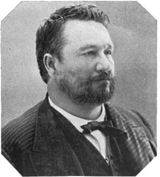
Joel Bryan Mayes was Principal Chief of the Cherokee Nation.

Joseph H. Vann was a Cherokee leader of mixed-race ancestry, a businessman and planter in Georgia, Tennessee and Indian Territory. He owned plantations, many slaves, taverns, and steamboats. In 1837, he moved with several hundred Cherokee to Indian Territory, as he realized they had no choice under the government's Indian Removal policy. He built up his businesses along the major waterways, operating his steamboats on the Tennessee, Ohio, Mississippi, and Arkansas rivers.
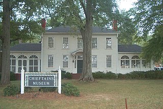
Chieftains Museum, also known as the Major Ridge Home, is a two-story white frame house built around a log house of 1819 in Cherokee country. It was the home of the Cherokee leader Major Ridge. He was notable for his role in negotiating and signing the Treaty of New Echota of 1835, which ceded the remainder of Cherokee lands in the Southeast to the United States. He was part of a minority group known as the Treaty Party, who believed that relocation was inevitable and wanted to negotiate the best deal with the United States for their people.

Cherokee history is the written and oral lore, traditions, and historical record maintained by the living Cherokee people and their ancestors. In the 21st century, leaders of the Cherokee people define themselves as those persons enrolled in one of the three federally recognized Cherokee tribes: The Eastern Band of Cherokee Indians, The Cherokee Nation, and The United Keetoowah Band of Cherokee Indians.

The Cherokee Nation was a legal, autonomous, tribal government in North America recognized from 1794 to 1907. It was often referred to simply as "The Nation" by its inhabitants. The government was effectively disbanded in 1907, after its land rights had been extinguished, prior to the admission of Oklahoma as a state. During the late 20th century, the Cherokee people reorganized, instituting a government with sovereign jurisdiction known as the Cherokee Nation. On July 9, 2020, the United States Supreme Court ruled that the Muscogee (Creek) Nation had never been disestablished in the years before allotment and Oklahoma Statehood.
The Cherokee removal, part of the Indian removal, refers to the removal of an estimated 15,500 Cherokees and 1,500 African-American slaves from the U.S. states of Georgia, North Carolina, Tennessee and Alabama to the West according to the terms of the 1835 Treaty of New Echota. It is estimated that 3,500 Cherokees and African-American slaves died en route.
The Echota Cherokee Tribe of Alabama is a state-recognized tribe in Alabama and Cherokee heritage group. It is based in northern Alabama and gained state-recognition under the Davis-Strong Act in 1984.
