This article may be expanded with text translated from the corresponding article in German. (October 2011)Click [show] for important translation instructions.
View a machine-translated version of the German article.
Machine translation like DeepL or Google Translate is a useful starting point for translations, but translators must revise errors as necessary and confirm that the translation is accurate, rather than simply copy-pasting machine-translated text into the English Wikipedia.
Do not translate text that appears unreliable or low-quality. If possible, verify the text with references provided in the foreign-language article.
You must provide copyright attribution in the edit summary accompanying your translation by providing an interlanguage link to the source of your translation. A model attribution edit summary is Content in this edit is translated from the existing German Wikipedia article at [[:de:Felda (Werra)]]; see its history for attribution.
You should also add the template {{Translated|de|Felda (Werra)}} to the talk page.
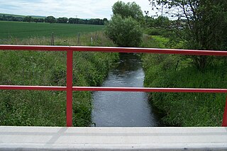
Felda is a river of Thuringia, Germany. It flows into the Werra in Dorndorf. The main source of the Felda is located immediately south of Erbenhausen am Bergsattel between the Stellberg (662.3 m) in the south and the Alten Mark (675.7 m) in the north at an altitude of about 510 m; The Herpf rises in the eastern neighborhood. A left source stream, called Rodgraben, rises at about 676 m altitude on the eastern slope of the Ellenbogen (813 m) and passes the place Reichenhausen immediately above the confluence.
After a route along the federal road 285 through Kaltensundheim, Kaltennordheim, Fischbach / Rhön, Diedorf, Neidhartshausen and Dermbach to Hartschimmern and further along the state road 1022 via Weilar, Stadtlengsfeld, Menzengraben and Dietlas, the Felda flows into the Dorndorf at an altitude of 225.1 m there from the east coming Weser source river Werra.
The route of the former Feldabahn follows its eponymous river between Kaltennordheim and Dorndorf and crosses it several times.
Thuringia, officially the Free State of Thuringia, is a state of Germany. Located in central Germany, it covers 16,171 square kilometres (6,244 sq mi), being the sixth smallest of the sixteen German States. It has a population of about 2.1 million.
The Weser is a river of Lower Saxony in north-west Germany. It begins at Hannoversch Münden through the confluence of the Werra and Fulda. It passes through the Hanseatic city of Bremen. Its mouth is 50 km (31 mi) further north against the ports of Bremerhaven and Nordenham. The latter is on the Butjadingen Peninsula. It then merges into the North Sea via two highly saline, estuarine mouths.
Malawi is a landlocked country in southeast Africa. It is wholly within the tropics; from about 9°30S at its northernmost point to about 17°S at the southernmost tip. The country occupies a thin strip of land between Zambia and Mozambique, extending southwards into Mozambique along the valley of the Shire River. In the north and north east it also shares a border with Tanzania. Malawi is connected by rail to the Mozambican ports of Nacala and Beira. It lies between latitudes 9° and 18°S, and longitudes 32° and 36°E.
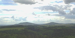
The Thuringian Forest, is a mountain range in the southern parts of the German state of Thuringia, running northwest to southeast. Skirting from its southerly source in foothills to a gorge on its north-west side is the Werra valley. On the other side of the Forest is an upper outcrop of the North German Plain, the Thuringian Basin, which includes the city Erfurt. The south and south-east continuation of the range is the highland often called the Thuringian-Vogtlandian Slate Mountains.
Schmalkalden-Meiningen is a Landkreis in the southwest of Thuringia, Germany. Its neighboring districts are the districts Wartburgkreis, Gotha, Ilm-Kreis, the district-free city Suhl, the district Hildburghausen, the Bavarian district Rhön-Grabfeld, and the district Fulda in Hesse.
The Rhön Mountains are a group of low mountains in central Germany, located around the border area where the states of Hesse, Bavaria and Thuringia come together. These mountains, which are at the extreme southeast end of the East Hesse Highlands, are partly a result of ancient volcanic activity. They are separated from the Vogelsberg Mountains by the river Fulda and its valley. The highest mountain in the Rhön is the Wasserkuppe which is in Hesse. The Rhön Mountains are a popular tourist destination and walking area.
The Little Cacapon River is a 25.1-mile-long (40.4 km) free-flowing tributary of the Potomac River in the center of Hampshire County, West Virginia. Via the Potomac River, its waters are part of the Chesapeake Bay watershed, leading to the Atlantic Ocean. The Little Cacapon enters the Potomac at an elevation of 499 feet (152 m) near the community of Little Cacapon. For the majority of its course the Little Cacapon is a shallow non-navigable stream. It has been historically referred to as both Little Cacapehon and Little Capecaphon. The name is pronounced kə-KAY-pən or KAY-pən.
Mill Branch is a 9.1-mile-long (14.6 km) tributary stream of the Cacapon River, belonging to the Potomac River and Chesapeake Bay watersheds. The stream is located in eastern Hampshire County in West Virginia's Eastern Panhandle.
The geographical region of Ladakh union territory is the highest altitude plateau region in India, incorporating parts of the Himalayan and Karakoram mountain ranges and the upper Indus River valley.
Philippsthal (Werra) is a market community in Hersfeld-Rotenburg district in eastern Hesse, Germany, right at the boundary with Thuringia.
The River Lavant is a winterbourne that rises at East Dean and flows west to Singleton, then south past West Dean and Lavant to Chichester. From east of Chichester its natural course was south to the sea at Pagham, but the Romans diverted it to flow around the southern walls of Chichester and then west into Chichester Harbour.
The Batten Kill, Battenkill, or Battenkill River is a 59.4-mile-long (95.6 km) river rising in Vermont that flows into New York and is a tributary of the Hudson River. As "kill" means a creek, the name "Battenkill River" is pleonastic.
The Hörsel is a 56 km (35 mi) long river in Thuringia, Germany, right tributary of the Werra. It is formed by the confluence of two smaller rivers in Leinatal, at the northern edge of the Thuringian Forest. The Hörsel flows generally northwest through the towns Hörselgau, Wutha-Farnroda and Eisenach. It flows into the Werra in Hörschel, a village near Eisenach.
The East Hesse Highlands describes a heavily wooded range of hills lying mainly in the German state of Hesse, but also extending a little way into Lower Saxony to the north, Thuringia to the east and Bavaria to the southeast. The region is sandwiched between the West Hesse Depression to the west, the Weser Uplands to the north, the Thuringian Basin to the northeast, the northwestern edge of the Thuringian Forest to the east, the Spessart to the south and the Wetterau to the southwest.
The Rennsteig is a ridge walk as well as an historical boundary path in the Thuringian Forest, Thuringian Highland and Franconian Forest in Central Germany. The long-distance trail runs for about 170 km from Eisenach and the Werra valley in the northwest to Blankenstein and the Selbitz river in the southeast.
Suhl is a river of Thuringia, Germany. It flows into the Werra near Berka/Werra.
The Gleichberge, which mainly comprise the Großer and Kleiner Gleichberg, are a small, inselberg-like mountain range, up to 679 m above sea level (NHN), in the southwestern part of the German state of Thuringia. They rise just east of the little ancient town of Römhild in the county of Hildburghausen.
Bad Salzungen station is the railway station of the town of Bad Salzungen in the German state of Thuringia. It is located on the Werra Railway and on the Werra Valley Railway.
The Salzungen Werra Upland is a natural region in Germany that forms part of the East Hesse Highlands in the German states of Hesse and Thuringia.
The Rhön Cycleway is a cycle path in Germany that runs for 180 kilometres from Bad Salzungen to Hammelburg. Its route takes it through 3 states: from Thuringia via Hesse to Bavaria.
This page is based on this Wikipedia article Text is available under the CC BY-SA 4.0 license; additional terms may apply. Images, videos and audio are available under their respective licenses.