
Pasig, officially the City of Pasig, is a highly urbanized city in the National Capital Region of the Philippines. According to the 2020 census, it has a population of 803,159 people.

Marikina, officially the City of Marikina, is a 1st class highly urbanized city in the National Capital Region of the Philippines. According to the 2020 census, it has a population of 456,159 people.

Antipolo, officially the City of Antipolo, is a 1st class component city and capital of the province of Rizal, Philippines. According to the 2020 census, it has a population of 887,399 people. It is the most populous city in the Calabarzon region, and the seventh most-populous city in the Philippines. It is also the most populated city under the component city status.

Cainta, officially the Municipality of Cainta, is a 1st class urban municipality in the province of Rizal, Philippines. According to the 2020 census, it has a population of 376,933 people.

Taytay, officially the Municipality of Taytay, is a 1st class urban municipality in the province of Rizal, Philippines. It is also known as the Garments Capital of the Philippines.

The Metropolitan Manila Development Authority is a government agency of the Philippines responsible for constituting the regional government of Metro Manila, comprising the capital city of Manila, the cities of Quezon City, Caloocan, Pasay, Mandaluyong, Makati, Pasig, Marikina, Muntinlupa, Las Piñas, Parañaque, Valenzuela, Malabon, Taguig, Navotas and San Juan, and the municipality of Pateros.
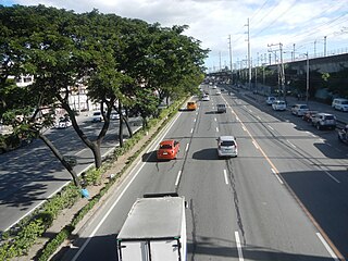
The Marikina–Infanta Highway, also known as Marcos Highway, Marilaque Highway, Marilaque Road or Marikina-Infanta Road, is a scenic mountain 117.5-kilometer (73.0 mi) highway that connects Metro Manila with Infanta, Quezon in the Philippines. Motorists colloquially refer to the road as Marilaque Highway.

Sta. Lucia Mall is a shopping mall owned by Sta. Lucia Realty & Development Inc. It is situated at the intersection of Marcos Highway, and Felix Avenue, located at Barangay San Isidro, Cainta, Rizal, Philippines, beside Robinsons Metro East.
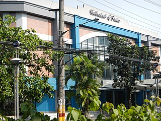
The Cathedral of Praise (COP) is a Full Gospel, Christ-centered megachurch based in Manila, Philippines. COP is headed by Pastors David and Beverley Sumrall.
Radial Road 6 is the sixth radial road in Metro Manila, the Philippines. It passes through the cities of Manila, Quezon City, San Juan, Pasig, and Marikina, as well as Cainta, and Antipolo in the province of Rizal up to Santa Maria, Laguna and Infanta, Quezon

Ortigas Avenue is a 12.1 km (7.5 mi) highway running from eastern Metro Manila to western Rizal in the Philippines. It is one of the busiest highways in Metro Manila, serving as the main thoroughfare of the metro's east–west corridor, catering mainly to the traffic to and from Rizal.

Marikina–Pasig station is an elevated Light Rail Transit (LRT) station located on the LRT Line 2 (LRT-2) system in San Roque, Marikina, near the tripoint boundary of Pasig, Metro Manila and Cainta, Rizal. The station is situated on the stretch of Marikina–Infanta Highway near the intersection of Gil Fernando Avenue–Felix Avenue and is named after the cities of Marikina and Pasig which the station straddles between.

The Manila East Road, also known as National Road and National Highway, is a two-to-four lane primary and secondary highway connecting Metro Manila to the provinces of Rizal and Laguna in the Philippines.

The Diocesan Shrine and Parish of Our Lady of Light, popularly known as Cainta Church, is a Roman Catholic parish church located along Andres Bonifacio Avenue in Barangay San Andres, Cainta, Rizal, in the Philippines. The church also operates a neighboring school, Cainta Catholic College. From its time of erection as a parish in 1760 until 1983, it belonged to the Archdiocese of Manila. It was placed under the newly created Diocese of Antipolo in 1983, which is now headed by Ruperto C. Santos. It belongs to the Vicariate of Our Lady of Light.

Kalayaan Avenue is a major east–west route in Makati and Taguig, Metro Manila, Philippines. For most of its length, it runs parallel to Jose P. Rizal Avenue to the north from East Rembo near Fort Bonifacio to Barangay Singkamas by the border with Santa Ana, Manila. It is interrupted by Bel-Air Village between Rockwell Drive and Epifanio de los Santos Avenue (EDSA). The avenue east of EDSA is designated as a component of National Route 190 of the Philippine highway network.
The Metro Rail Transit Line 4 (MRT-4) is an upcoming rapid transit line serving the Greater Manila Area of the Philippines. The 12.7 km (7.9 mi), 10-station elevated railway will connect Ortigas Center in Metro Manila and the suburban municipality of Taytay, Rizal. It will traverse along Ortigas Avenue and Manila East Road, starting at the former's junction with EDSA in Quezon City to the west until it terminates near the New Taytay Public Market to the east.

Radial Road 5, more commonly referred to as R-5, is a network of roads and bridges that all together form the fifth radial road of Manila in the Philippines. The road links the City of Manila with Mandaluyong and Pasig in the east, leading out of Metro Manila into the province of Rizal and south towards Laguna. It is the only arterial road traversing the east side of Laguna de Bay.

The following is an alphabetical list of articles related to the Philippine capital region of Metro Manila.

National Route 59 (N59) is a primary national route that forms part of the Philippine highway network, running from Antipolo, Rizal to Cubao, Quezon City, Metro Manila.