
Spurr Township is a civil township of Baraga County in the U.S. state of Michigan. The population was 276 at the 2010 census.

The Red Cedar River is a tributary of the Grand River in central Michigan in the United States. The river is approximately 51.1 miles (82.2 km) long and drains a watershed of approximately 461 square miles (1,190 km2) in the Lansing–East Lansing metropolitan area and suburban and rural areas to the east.
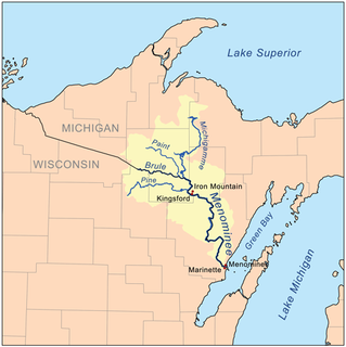
The Menominee River is a river in northwestern Michigan and northeastern Wisconsin in the United States. It is approximately 116 miles (187 km) long, draining a rural forested area of northern Wisconsin and the Upper Peninsula of Michigan into Lake Michigan. Its entire course, with that of its tributary, the Brule River, forms part of the boundary between the two states.

The Chippewa River is a stream in the U.S. state of Michigan that runs 91.8 miles (147.7 km) through the central Lower Peninsula. The Chippewa is a tributary of the Tittabawassee River and is thus part of the Saginaw River drainage basin. The river is named after the Chippewa people.

Van Riper State Park is a 1,055-acre (4.27 km2) park located in the Upper Peninsula of the U.S. state of Michigan, 17 miles (27 km) west of Ishpeming on US Highway 41. It lies partly in Michigamme Township and partly in Champion Township, both in Marquette County. The park has about 1.5 miles (2.4 km) of frontage along the eastern shores of Lake Michigamme, and 1.5 miles (2.4 km) of frontage along the shores of the Peshekee River.
Carp River is a 40.2-mile-long (64.7 km) river in Chippewa and Mackinac counties in the U.S. state of Michigan. 21.7 miles (34.9 km) of the river were added to the National Wild and Scenic Rivers System in 1992.
The Black River is a 41.1-mile-long (66.1 km) river on the Upper Peninsula of the U.S. state of Michigan, flowing mostly in Gogebic County into Lake Superior at 46°40′03″N90°02′57″W. Its source at 46°18′54″N90°01′15″W is a boreal wetland on the border with Iron County, Wisconsin. The northern section of the river, 14 miles (23 km) within the boundaries of the Ottawa National Forest, was designated a National Wild and Scenic River in 1992.
Black River is a 29.8-mile-long (48.0 km) river on the Upper Peninsula of the U.S. state of Michigan. The river flows into the Middle Branch Escanaba River in Ely Township of Marquette County at 46°23′53″N87°46′15″W and on into Lake Michigan.
Cedar River is a 67.1-mile-long (108.0 km) river in the U.S. state of Michigan. It rises in the northern part of Menominee County at 45°53′18″N87°35′15″W and flows mostly south and east to empty into Green Bay of Lake Michigan at 45°24′35″N87°21′05″W in the community of Cedar River.

The Ontonagon River is a river flowing to Lake Superior on the western Upper Peninsula of Michigan in the United States. The main stem of the river is 25 miles (40 km) long and is formed by a confluence of several longer branches, portions of which have been collectively designated as a National Wild and Scenic River. Several waterfalls occur on the river including Agate Falls and Bond Falls.
The Mitchigan River is a 14.9-mile-long (24.0 km) stream in the Upper Peninsula of the U.S. state of Michigan. It flows into the Fence River at 46°17′27″N88°09′58″W in northeast Iron County in Mansfield Township. The Fence River is a tributary of the Michigamme River, which is itself a tributary the Menominee River, flowing to Lake Michigan. The Mitchigan River has its source in the southeast corner of Baraga County at 46°24′58″N88°08′05″W. It flows mostly southward along the boundary between Iron and Marquette counties, crossing briefly into western Marquette County.
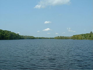
Lake Michigamme, one of Michigan's largest lakes, reaches a depth of over 70 feet (21 m). It covers 4,292 acres (17.37 km2) in Marquette and Baraga County, Michigan. Van Riper State Park provides public access. The vast majority of the lake lies in Marquette County, with only its westernmost part extending into Baraga County.
The Michigamme River is a 67.0-mile-long (107.8 km) tributary of the Menominee River on the Upper Peninsula of Michigan in the United States. Via the Menominee River, its water flows to Lake Michigan.

The Ocqueoc River is stream in Presque Isle County in the northeastern part of the lower peninsula in the U.S. state of Michigan. It is 34.2 miles (55.0 km) long and encompasses a watershed of approximately 94,394 acres (382.00 km2).
The Peshekee River is a 31.1-mile-long (50.1 km) river on the Upper Peninsula of Michigan in the United States. It is a tributary of Lake Michigamme, and its waters flow via the Michigamme River and the Menominee River to Lake Michigan.
The Spruce River is a 9.9-mile-long (15.9 km) tributary of the Michigamme River on the Upper Peninsula of Michigan in the United States. Via the Michigamme River and the Menominee River, it is a tributary of Lake Michigan.

Indian River is a 59.1-mile-long (95.1 km) tributary of the Manistique River on the Upper Peninsula of Michigan in the United States. It rises out of Hovey Lake at 46°17′36″N86°42′20″W on Hiawatha National Forest land in Alger County and flows south and east through a lake district and on through Schoolcraft County. The river flows into the 8,659 acre (35 km²) Indian Lake at 46°17′36″N86°42′20″W and flows out at 45°59′30″N86°17′15″W. It then flows east and south about 2.5 miles where it merges with the Manistique River, which then flows through Manistique and into Lake Michigan at 45°56′56″N86°14′45″W.
Carp River is a 10.3-mile-long (16.6 km) river in Gogebic and Ontonagon counties in the U.S. state of Michigan. The Carp River is formed by the outflow of the Lake of the Clouds at 46°48′04″N89°45′38″W in the Porcupine Mountains of the Upper Peninsula.
Little Carp River is a 15-mile-long (24 km) river in Gogebic and Ontonagon counties in the U.S. state of Michigan. The Carp River rises at 46°45′54″N89°44′44″W in the Porcupine Mountains of the Upper Peninsula.


