
The Township of Langley is a district municipality immediately east of the City of Surrey in southwestern British Columbia, Canada. It extends south from the Fraser River to the U.S. border, and west of the City of Abbotsford. Langley Township is not to be confused with the City of Langley, which is adjacent to the township but politically is a separate entity. Langley is located in the eastern part of Metro Vancouver.

Pitt Meadows is a municipality of Metro Vancouver in southwestern British Columbia, Canada. Incorporated in 1914, it has a land area of 85.38 square kilometres (32.97 sq mi) and a population of 18,573. The municipality receivied its name from the Pitt River and Pitt Lake. Pitt Meadows is one of 21 municipalities plus Electoral Area A that comprises the Metro Vancouver Regional District.

The City of Langley, commonly referred to as Langley City, or just Langley, is a municipality in the Metro Vancouver Regional District in British Columbia, Canada. It lies directly east of Surrey, adjacent to the Cloverdale area, and is surrounded elsewhere by the Township of Langley, bordered by its neighbourhoods of Willowbrook to the north, Murrayville to the east, and Brookswood and Fern Ridge to the south.

Fort Langley is a village community in Township of Langley, British Columbia, Canada. It has a population of approximately 3,400 people. It is the home of Fort Langley National Historic Site, a former fur trade post of the Hudson's Bay Company. Lying on the Fraser River, Fort Langley is at the northern edge of the Township of Langley.
Walnut Grove is a town centre located within the Township of Langley, British Columbia.
Aberdeen is a neighbourhood in the southern area of Kamloops, British Columbia. It is bordered by Highway 5A to the east and the Trans Canada Highway to the north. Located on the slope of the southern hills overlooking Kamloops, Aberdeen overlooks the city and surrounding Thompson River valley from the south. The neighbourhood gets its name John Campbell Gordon, seventh Earl of Aberdeen, Governor General of Canada from 1893 to 1898. He visited Kamloops in November 1894.
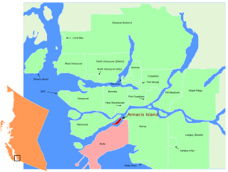
Annacis Island is a narrow island under the jurisdiction of City of Delta in Lower Mainland, British Columbia, located just downstream of the south arm of the Fraser River bifurcation between Lulu Island to the north and the Delta peninsula to the south. The island is now mostly an industrial zone, and contains one of Metro Vancouver's secondary wastewater treatment plants, the Annacis Island Wastewater Treatment Plant. The island is also home to the British Columbia Institute of Technology's Annacis Island campus.

Brookswood is a community in the Township of Langley, British Columbia, Canada, located on the west side of that municipality to the south of the Nicomekl River. It is largely a residential area with several commercial areas, a Recreation Centre with a hockey area and curling rink.
Aldergrove is a community in the Township of Langley within British Columbia, Canada, approximately 59 km (37 mi) east of Vancouver. The community is urban in nature and, although not incorporated as a town, is often referred to as one. Aldergrove is located at the southeastern edge of both the Township of Langley and the Greater Vancouver metropolitan area, near the western edge of the Abbotsford metropolitan area. It is home to one of the Lower Mainland's five land border crossings, connecting Aldergrove and Lynden, Washington.

Willowbrook Shopping Centre is a shopping centre in the Fraser Valley area of Metro Vancouver, Canada. Situated on Fraser Highway at Highway 10, Willowbrook is located between the City of Langley and Langley Township in British Columbia. The mall is 40 minutes southeast of Vancouver. As of January 2021, Willowbrook Shopping Centre has over 60,064 square metres (646,520 sq ft) of retail space.
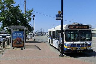
Langley Centre is the major public transit exchange serving the City of Langley and the Township of Langley in British Columbia, Canada. Opened on October 31, 1975, it is home to Langley's bus routes and community shuttle routes; some of Langley's bus routes connect to the SkyTrain system at Surrey Central station.

Ocean Park is a neighbourhood of South Surrey, a region of Surrey, British Columbia.
Albion, British Columbia is a neighbourhood in Maple Ridge, British Columbia and is one of several small towns incorporated within the municipality at its creation. It is the oldest non-indigenous community of the district's settlements, and is only slightly younger than Fort Langley, adjacent across the Fraser River, and Kanaka Creek, which is just to the west and lies along the creek of the same name. Its official definition is the area bounded by the Fraser River, Kanaka Way, and 240th Street, but in its historic sense it means the community centred on and flanking 240th Street and adjoining areas along the Fraser River waterfront and around the Maple Ridge Fairgrounds, while along Kanaka Way and also on the near bank of Kanaka Creek, the creek, is historically the community of Kanaka Creek. Burgeoning newer home construction east of 240th Street near the Lougheed Highway is also often referred to as part of Albion.

Murrayville is a small community in the Township of Langley in the Lower Mainland region of British Columbia, Canada.
Mount Lehman or Mt. Lehman is a small rural community located in the Fraser Valley of south western British Columbia, Canada. The community was established in 1874 and became part of the District of Matsqui in 1892. The District of Matsqui was incorporated into the present day City of Abbotsford, British Columbia in 1995.
Willoughby, British Columbia is a community located within the Township of Langley. It is also home to the Township of Langley's municipal hall.
The Katzie First Nation or Katzie Nation is the band government of the Katzie people of the Lower Fraser Valley region of British Columbia, Canada.
Port Hammond, commonly known as Hammond, is a community on the Fraser River within the city of Maple Ridge, British Columbia, Canada, near its border with the City of Pitt Meadows and just east of the Golden Ears Bridge.
The Leqʼ a꞉ mel First Nation, formerly known as the Lakahahmen First Nation, is a First Nations band government whose community and offices are located in the area near Deroche, British Columbia, Canada, about 12 kilometres east of the District of Mission. They are a member government of the Sto:lo Nation Chiefs Council, which is one of two tribal councils of the Sto:lo.

Carvolth Exchange is a major bus loop and park and ride facility serving the northern portion of the Township of Langley. Opened on December 1, 2012, Carvolth Exchange's primary connections are to Vancouver, Surrey and Langley City all operated by TransLink.
