
Westphalia is a region of northwestern Germany and one of the three historic parts of the state of North Rhine-Westphalia. It has an area of 20,210 square kilometres (7,800 sq mi) and 7.9 million inhabitants.

North Rhine-Westphalia or North-Rhine/Westphalia, commonly shortened to NRW, is a state (Land) in Western Germany. With more than 18 million inhabitants, it is the most populous state in Germany. Apart from the city-states, it is also the most densely populated state in Germany. Covering an area of 34,084 km2 (13,160 sq mi), it is the fourth-largest German state by size.
Siegen-Wittgenstein is a Kreis (district) in the southeast of North Rhine-Westphalia, Germany. Neighboring districts are Olpe, Hochsauerlandkreis, Waldeck-Frankenberg, Marburg-Biedenkopf, Lahn-Dill, Westerwaldkreis, and Altenkirchen.

The Sieg is a river in North Rhine-Westphalia and Rhineland-Palatinate, Germany. It is a right tributary of the Rhine.

The Siegerland is a region of Germany covering the old district of Siegen and the upper part of the district of Altenkirchen, belonging to the Rhineland-Palatinate adjoining it to the west.

The Inde is a small river in Belgium and in North Rhine-Westphalia, Germany

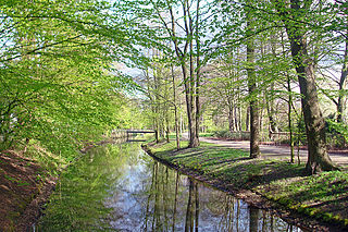
The Düssel is a small right tributary of the river Rhine in North Rhine Westphalia, Germany. Its source is east of Wülfrath. It flows westward through the Neander Valley where the fossils of the first known to be Neanderthal man were found in August 1856. At Düsseldorf it forms a river delta by splitting into four streams, which all join the Rhine after a few kilometres. The Nördliche Düssel flows through the Hofgarten and passes under the Golden Bridge.

The Kyll, noted by the Roman poet Ausonius as Celbis, is a 128-kilometre-long (80 mi) river in western Germany, left tributary of the Moselle. It rises in the Eifel mountains, near the border with Belgium and flows generally south through the towns Stadtkyll, Gerolstein, Kyllburg and east of Bitburg. It flows into the Moselle in Ehrang, a suburb of Trier.

Hilchenbach is a town in the Siegen-Wittgenstein Kreis (district) of North Rhine-Westphalia, Germany.

Kreuztal is a town in the Siegen-Wittgenstein district, in North Rhine-Westphalia, Germany.

The Itter is a river of Hesse and of North Rhine-Westphalia, Germany. It is a left tributary of the Diemel in the Waldeck-Frankenberg district in Hesse and in the Hochsauerland district in North Rhine-Westphalia. It flows through Willingen.
Dalke is a river of North Rhine-Westphalia, Germany. It flows into the Ems near Gütersloh.
Heesbach is a small river of North Rhine-Westphalia, Germany. It flows into the Littfe in Kreuztal.

The Littfe is a river of North Rhine-Westphalia, Germany in the township of Kreuztal (Westphalia). Its length is 12.7 kilometres (7.9 mi). The well is southeast of Welschen-Ennest in the village of Burgholdinghausen. Littfe flows through Littfeld, the village that has got its name by the river, Krombach and Eichen. In the centre of Kreuztal it flows into the river Ferndorfbach.
Kredenbach is a constituent community of Kreuztal, Siegen-Wittgenstein, North Rhine-Westphalia, Germany.

Junkernhees is a constituent community of Kreuztal, Siegen-Wittgenstein, North Rhine-Westphalia, Germany.
Fellinghausen is a constituent community of Kreuztal, Siegen-Wittgenstein, North Rhine-Westphalia, Germany.
Osthelden is a constituent community of Kreuztal, Siegen-Wittgenstein, North Rhine-Westphalia, Germany and has its name from the stream Osthelde. It is located on the road from Wenden to Kreuztal, where the road descends into the valley with a sharp bend and has 710 inhabitants.

The Kreuztal–Cölbe railway is a 88-kilometre-long main line in Hesse and North Rhine-Westphalia, Germany. It branches off the Ruhr–Sieg railway at Kreuztal and runs via Erndtebrück, Bad Laasphe and Biedenkopf to Cölbe. Operationally, the line is now divided into two parts. The Kreuztal–Erndtebrück section is operated together with the Erndtebrück–Bad Berleburg railway as the Rothaar-Bahn and the subsequent section to Cölbe, now operated by the Kurhessenbahn, is called the Obere Lahntalbahn. Trains at the eastern end of the line run to/from Marburg (Lahn).

Siegerland-Höhenring(Siegerland mountain ridge circular route) is an approximately 142-kilometre-long (88-mile-long) hiking trail in Germany that circles most parts of Siegerland in the districts of Siegen-Wittgenstein and Altenkirchen.

