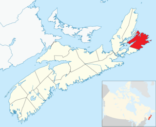
Cape Breton County is one of eighteen counties in the Canadian province of Nova Scotia. It is located on Cape Breton Island.

Sierra National Forest is a U.S. National Forest located on the western slope of central Sierra Nevada in Central California and bounded on the northwest by Yosemite National Park and the south by Kings Canyon National Park. The forest is known for its mountain scenery and natural resources. Forest headquarters are located in Clovis, California. There are local ranger district offices in North Fork and Prather.

Strathcona County is a specialized municipality in central Alberta, Canada between Edmonton and Elk Island National Park.

Oakleigh East is a suburb of Melbourne, Victoria, Australia 16 km south-east of Melbourne's central business district. Its local government area is the City of Monash. The suburb is mostly residential with some commercial lots. The suburb is bordered by Ferntree Gully Road to the north, Clayton Road to the east, North Road to the south, and Princes Hwy and Franklyn St to the west. At the 2016 Census, Oakleigh East had a population of 6,444.

Rocky View County is a municipal district in southern Alberta, Canada that is named for its views of the nearby Rocky Mountains to the west. It surrounds most of Calgary, forming the city's northern boundary and most of the city's western and eastern boundaries. At a population of 39,407 in 2016, Rocky View County is the most populous municipal district in Alberta. Though predominantly rural in nature, Rocky View County is home to 14 hamlets, including Langdon, one of Alberta's most populous hamlets. Its rural areas are home to numerous country residential subdivisions.
Poundmaker Trail is a 361-kilometre (224 mi) interprovincial highway in Western Canada that runs from Edmonton, Alberta to North Battleford, Saskatchewan, following Alberta Highway 14 and Saskatchewan Highway 40. The highway is named after Pitikwahanapiwiyin, commonly known as Poundmaker, a Plains Cree chief known as a peacemaker and defender of his people.

The Northern Woods and Water Route is a 2,400-kilometre (1,500 mi) route through northern British Columbia, Alberta, Saskatchewan and Manitoba in Western Canada. As early as the 1950s community groups came together to establish a northern travel route; this was proposed as the Northern Yellowhead Transportation Route. The Northern Woods and Water Route Association was established in 1974, and encouraged promotion of the route with the promise of an increase in tourist travel. The route was designated in 1974 and is well signed throughout the connector highways. The route starts at Dawson Creek at the British Columbia Spirit River Highway 49 and ends at Winnipeg, Manitoba, running through the northern region of the western provinces. The Northern Woods and Water Route (NWWR) includes connector routes from west to east including British Columbia Highway 49, Alberta Highway 49, AB Hwy 2A, AB Hwy 2, AB Hwy 55, Saskatchewan Highway 55, SK Hwy 9, Manitoba Provincial Road 283, Manitoba Highway 10, MB PTH 5, MB PTH 68, MB PTH 6. The halfway point of the NWWR is approximately at Goodsoil, Saskatchewan.
Highway 14 is a highway in the Canadian province of Saskatchewan. It runs from the Alberta border where it becomes Highway 13 to intersection of Circle Drive and 22nd Street in Saskatoon. It is approximately 250 km (160 mi) long.
Highway 6 is a paved undivided major provincial highway in the Canadian province of Saskatchewan. It runs from Montana Highway 16 at the Canada–US border near the Canada customs port of Regway to Highway 55 near Choiceland. Highway 6 is about 523 km (325 mi) long. The CanAm Highway comprises Saskatchewan Highways from south to north: SK 35, Sk 39, Sk 6, Sk 3, as well as Sk 2. 330 kilometres (210 mi) of Saskatchewan Highway 6 contribute to the CanAm Highway between Corinne and Melfort.
Highway 3 is a major provincial paved undivided highway in the Canadian province of Saskatchewan. It runs from the Alberta border, where it continues west as Alberta Highway 45, to the Manitoba border, and then continues east as Highway 77. Highway 3 is about 615 km (382 mi.) long. The CanAm Highway comprises Saskatchewan Highways 35, 39, 6, 2, as well as 2. 59.7 miles (96.1 km) of Saskatchewan Highway 3 contribute to the CanAm Highway between Melfort and Prince Albert.
Highway 56 is a highway in the Canadian province of Saskatchewan. It runs from Highway 1 near Indian Head to Highway 210 within the Echo Valley Provincial Park. Highway 56 is about 55 km (34 mi) long.
Highway 210 is a highway in the Canadian province of Saskatchewan. It runs from Highway 10 to Highway 35 in Fort Qu'Appelle. Highway 210 is about 21 km (13 mi) long.

Highway 35 is a paved undivided provincial highway in the Canadian province of Saskatchewan. It runs from the US Border near Port of Oungre to a dead end near the north shore of Tobin Lake. Saskatchewan Highway 35 (SK Hwy 35) is about 569 kilometres (354 mi) long. The CanAm Highway comprises Saskatchewan Highways 35, SK Hwy 39, SK Hwy 6, SK Hwy 3, SK Hwy 2 and U.S. Route 85. 74.6 kilometres (46.4 mi) of SK Hwy 35 contribute to the CanAm Highway between Port of Oungre on the Canada – United States border and Weyburn. Mudslides, and spring flooding were huge road building and maintenance problems around Nipawin as well as along the southern portion of the route named the Greater Yellow Grass Marsh. Over 20 early dams were built until the problem was addressed with the Rafferty-Alameda Project on the Souris River and the construction of the Qu'Appelle River Dam which have helped to eliminate washed out roads and flooded communities. The highway through the homesteading community followed the Dominion Land Survey on the square until reaching the Saskatchewan River at Nipawin. The completion of the combined railway and traffic bridge over the Saskatchewan River at Nipawin in the late 1920s retired the ferry and basket crossing for traffic north of Nipawin. The E.B. Campbell Dam built in 1963 northeast of Nipawin created Tobin Lake, and Codette Lake was formed with the construction of the Francois-Finlay Hydroelectric dam at Nipawin. The railway/traffic bridge that formed part of Highway 35 was the only crossing utilized at Nipawin until a new traffic bridge was constructed in 1974. The new bridge then became part of the combined Highway 35 and 55 until the highway parts just east of White Fox. Highway 35 then continued north along the west side of Tobin Lake. The railway/traffic bridge continues to be utilized for one lane vehicle traffic controlled by traffic lights, and continues as the "old highway 35" on the west side of the river until it joins with the current Highway 35/55.

Cruzville is a census-designated place in Catron County, New Mexico, United States, 9 miles (14 km) northeast of Reserve. It is located in the Apache National Forest. As of the 2010 census it had a population of 72.
Mecatepe Lagoon Natural Reserve is a nature reserve in Nicaragua. It is one of the 78 reserves that are under official protection in the country. It is located in southern Granada Department, east of hwy 1.

Airport Business Area is an industrial park located in the North Industrial SDA Suburban Development Area of Saskatoon, Saskatchewan. Industrial parks are usually located close to transport facilities, especially where more than one transport modalities coincide. The Idylwyld Drive North, Sk Hwy 11 Louis Riel Trail, and Sk Hwy 12 concurrency are all accessed directly from the Airport Business Area. The Saskatoon John G. Diefenbaker International Airport is north of the Airport Business Area. Circle Drive marks the southern boundary, with access to SK Hwy 14 and Sk Hwy 16, the Yellowhead Trans Canada.
Saskatchewan Highway 658 connects Saskatchewan Highway 4 near Red Pheasant Indian Reserve 108 to SK Hwy 4 near Battleford. Highway 658 travels around Mosquito Indian Reserve 109, whereas Highway 4 travels north through the Indian Reserve. To the north of Mosquito Indian Reserve 109 is Grizzly Bear's Head and Lean Man Indian Reserve. The centre of Battleford is 1.5 kilometres (0.93 mi) from the Highway 658 Highway 4 junction. The length of Highway 658 is 41.2 kilometres (25.6 mi).

Hwy 55 Burgers Shakes & Fries is a fast casual restaurant chain that operates primarily on the East Coast of the United States. Formerly known as Andy's Cheesesteaks and Cheeseburgers, the first location opened in Goldsboro, North Carolina, in 1991. It now has 135 restaurants in the United States, the United Arab Emirates, and Denmark.

Laura Bay Conservation Park is a protected area located in the Australian state of South Australia on the west coast of Eyre Peninsula adjoining the headland of Laura Bay Point in the gazetted locality of Laura Bay about 20 kilometres south east of the town of Ceduna.
Highway 622 is a highway in the Canadian province of Saskatchewan. It runs from the Hwy 306 at Riceton, across Hwy 33, through Kronau, to the Hwy 1/Hwy 46 intersection near Balgonie. Hwy 622 is about 44 kilometres (27 mi) long.

