Chiltepe Peninsula Natural Reserve

Last updated
Chiltepe Peninsula Natural Reserve
Reserva Natural Península de Chiltepe
Nicaragua location map.svg
Red pog.svg
Coordinates 12°15′00″N86°21′00″W / 12.25000°N 86.35000°W / 12.25000; -86.35000 Coordinates: 12°15′00″N86°21′00″W / 12.25000°N 86.35000°W / 12.25000; -86.35000

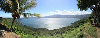
Chiltepe Peninsula Natural Reserve (Spanish: Reserva Natural Península de Chiltepe) is a nature reserve in Nicaragua. It is one of the 78 reserves which are officially under protection in the country.

Spanish language Romance language

Spanish or Castilian is a Western Romance language that originated in the Castile region of Spain and today has hundreds of millions of native speakers in the Americas and Spain. It is a global language and the world's second-most spoken native language, after Mandarin Chinese.

Nature reserve protected area for flora, fauna or features of geological interest

A nature reserve is a protected area of importance for flora, fauna or features of geological or other special interest, which is reserved and managed for conservation and to provide special opportunities for study or research. Nature reserves may be designated by government institutions in some countries, or by private landowners, such as charities and research institutions, regardless of nationality. Nature reserves fall into different IUCN categories depending on the level of protection afforded by local laws. Normally it is more strictly protected than a nature park.

Nicaragua Country in Central America

Nicaragua, officially the Republic of Nicaragua, is the largest country in the Central American isthmus, bordered by Honduras to the northwest, the Caribbean to the east, Costa Rica to the south, and the Pacific Ocean to the southwest. Managua is the country's capital and largest city and is also the third-largest city in Central America, behind Tegucigalpa and Guatemala City. The multi-ethnic population of six million includes people of indigenous, European, African, and Asian heritage. The main language is Spanish. Indigenous tribes on the Mosquito Coast speak their own languages and English.

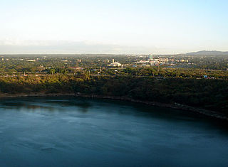
Located on the South shore of Lake Managua, it is 15 kilometers Northwest of Managua, the capital, and consequently a popular destination for visitors from the city.

Lake Managua lake in Nicaragua

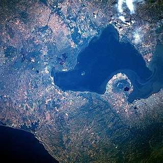
Lake Managua is a lake in Nicaragua. The Spanish name is Lago de Managua or Lago Xolotlán. At 1,042 km², it is approximately 65 kilometres (40 mi) long and 25 kilometres (16 mi) wide. Similarly to the name of Lake Nicaragua, its name was coined by the Spanish conquerors from "Mangue" and agua ("water"). The city of Managua, the capital of Nicaragua, lies on its southwestern shore.

Managua Place in Nicaragua

Managua is the capital and largest city of Nicaragua, and the center of an eponymous department. Located on the southwestern shore of Lake Managua, it had an estimated population 1,042,641 in 2016 within the city's administrative limits and a population of 1,401,687 in the metropolitan area, which additionally includes the municipalities of Ciudad Sandino, El Crucero, Nindirí, Ticuantepe and Tipitapa.

The peninsula was formed by Apoyeque stratovolcano, [1] one of whose domes is Chiltepe volcano (Volcán Chiltepe). [2]

Local fauna includes coyotes, deer, raccoons, rabbits and other small mammals, as well as iguanas and lizards, which have been disappearing under pressure from hunting. At its coasts live ducks, herons, cormorants, and such birds as sargentillos (Agelaius), cowbirds (Molothrus Tangavius), Clariona (Cassidix mexicanus), and zanatillo (Cassidis nicaraguensis). The latter species is endemic to the coasts of lakes in Nicaragua.

Among the threats affecting the conservation of the protected area are frequent forest fires and expansion of agricultural areas at the expense of the nature reserve. [3]

Related Research Articles

Geography of Nicaragua

Nicaragua is a country in Central America, bordering both the Caribbean Sea and the North Pacific Ocean, between Costa Rica and Honduras. Nicaragua is the largest country in Central America.

Jinotega Department Department of Nicaragua

Jinotega is a department of Nicaragua. Its departmental head is Jinotega. It is located in the north of the country, on the border with Honduras.

Ometepe island

Ometepe is an island formed by two volcanoes rising out of Lake Nicaragua in the Republic of Nicaragua. Its name derives from the Nahuatl words ome (two) and tepetl (mountain), meaning "two mountains". It is the largest island in Lake Nicaragua.

Masaya Volcano Volcán Masaya

Masaya is a caldera located in Masaya, Nicaragua, 20 km south of the capital Managua. It is Nicaragua's first and largest national park, and one of 78 protected areas of Nicaragua. The complex volcano is composed of a nested set of calderas and craters, the largest of which is Las Sierras shield volcano and caldera. Within this caldera lies a sub-vent, which is Masaya Volcano sensu stricto. The vent is a shield type composing of basaltic lavas and tephras and includes a summit crater. This hosts Masaya caldera, formed 2,500 years ago by an 8-km³ basaltic ignimbrite eruption. Inside this caldera a new basaltic complex has grown from eruptions mainly on a semi-circular set of vents that include the Masaya and Nindiri cones. The latter host the pit craters of Masaya, Santiago, Nindiri and San Pedro. Observations in the walls of the pit craters indicate that there have been several episodes of cone and pit crater formation.

Mombacho mountain

Mombacho is a stratovolcano in Nicaragua, near the city of Granada. It is 1344 metres high. The Mombacho Volcano Nature Reserve is one of 78 protected areas of Nicaragua. Mombacho is not an extinct volcano but the last eruption occurred in 1570. There is no historical knowledge of earlier eruptions.

Ticuantepe Municipality in Managua, Nicaragua

Ticuantepe is a municipality in the Managua department of Nicaragua with an estimated population of 34,000.

Masaya Municipality in Masaya Department, Nicaragua

Masaya is the capital city of Masaya department in Nicaragua. It is situated approximately 14 km west of Granada and 31 km southeast from Managua.

Azufral mountain in Colombia

Azufral is a stratovolcano located in the department of Nariño in southern Colombia, 12 km (7 mi) west of the town of Túquerres. It is the only volcano of the Western Ranges of the Colombian Andes. Its name derives from the Spanish word for sulfur, azufre. The volcano is considered semi-dormant but there are numerous fumaroles in the summit crater. The summit of the volcano has an altitude of 4,070 metres (13,350 ft), and the north-western side of the crater contains a crescent-shaped lake named Laguna Verde at 3,970 m (13,025 ft). The lake is 1,100 m (0.68 mi) long and 600 metres (2,000 ft) wide. and its bright green color is a result of the sulfur and iron-based deposits in the crater. There are also two other much smaller lakes in the crater, Laguna Negra and Laguna Cristal.

Apoyeque

Apoyeque is a pyroclastic shield, located in the Chiltepe Peninsula Natural Reserve in Nicaragua. It has a 2.8-km wide, 400-m-deep, lake-filled caldera.

Tourism in Nicaragua

Tourism in Nicaragua has grown considerably recently, and it is now the second largest industry in the nation. Nicaraguan President Daniel Ortega has stated his intention to use tourism to combat poverty throughout the country.

Protected areas of Nicaragua

The protected areas of Nicaragua are areas that have natural beauty or significance and are protected by Nicaragua. Nicaragua has 78 protected areas that cover 22,422 km², about 17.3% of the nations landmass. The National System of Protected Areas (SINAP) is administered by the Ministry of the Environment and Natural Resources (MARENA).

Chocoyero-El Brujo Natural Reserve protected area

Chocoyero-El Brujo Natural Reserve is located in the municipality of Ticuantepe in the Managua department of Nicaragua. Chocoyero-El Brujo is one of 78 protected areas in Nicaragua, and at just 455 acres (1.8 km2) this tropical forest is one of the smallest in size. Chocoyero-El Brujo was declared a natural reserve in 1993 is managed by the Ministry of the Environment and Natural Resources (MARENA).

Apoyo Lagoon Natural Reserve

Laguna de Apoyo Nature Reserve is a nature reserve located between the departments of Masaya and Granada in Nicaragua. Lake Apoyo was declared a nature reserve in 1991 and is managed by the Ministry of the Environment and Natural Resources (MARENA) and comprises one of 78 protected areas of Nicaragua. Geological data suggests that Lake Apoyo originated about 23,000 years ago.

Tiscapa Lagoon Natural Reserve

Tiscapa Lagoon is a lagoon of volcanic origin that formed over 10,000 years ago. It is located in the capital city of Managua in Nicaragua, and covers an area of 0.13 km2. Tiscapa Lagoon was protected as a natural reserve on October 31, 1991. The reserve is managed by the Ministry of the Environment and Natural Resources (MARENA) and comprises one of the 78 protected areas of Nicaragua.

Tepesomoto-La Pataste Natural Reserve

Tepesomoto-Pataste Natural Reserve is a nature reserve in Nicaragua. It is one of the 78 reserves that are under official protection in the country.

The Protected areas of Portugal are classified under a legal protection statue that allows for the adequate protection and maintenance of biodiversity, while providing services for ecosystem that maintains the natural and geological patrimony.

References

  1. "Apoyeque Volcano, Global Volcanism Program, Smithsonian National Museum of Natural History" . Retrieved 2010-06-25..
  2. "Volcán Chiltepe, in geographic.org" . Retrieved 2010-06-25..
  3. "Reserva Natural Península de Chiltepe (in Spanish), Ministry of the Environment and Natural Resources, Government of Nicaragua" . Retrieved 2010-06-25..