Finik | |
---|---|
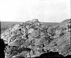
View of the ruins at Finik (the ancient Pinaca) | |
Coordinates: 37°25′N42°05′E / 37.417°N 42.083°E Coordinates: 37°25′N42°05′E / 37.417°N 42.083°E [1] | |
Country | Turkey |
Province | Şırnak |
Finik is an archaeological site in southeastern Turkey. It is located on the rocky cliffs overlooking the eastern bank of the Tigris, 14 kilometers upstream from the city of Cizre. [1] It has been identified with the ancient Pinaka, mentioned by Strabo as one of the principal cities of the region of Gordyene. [2] The medieval Islamic medieval writers al-Ya'qubi and Abu'l-Fida, who called the site Fenek or Fanak, described it as the site of an impregnable fortress, the ruins of which still stand. [1]
It gained the attention of some scholars in the late 19th and early 20th centuries, but was not studied thereafter, perhaps in part due to the difficulty of accessing it, with only trails leading along the bottom of the cliffs allowing access. The site is primarily characterized by a prominent rocky outcrop overlooking the Tigris valley, upon which there are the scattered ruins of Islamic-era fortifications. These appear to correspond to the fortress mentioned by al-Ya'qubi and Abu'l-Fida. Some of these ruins also appear to be quite recent. [1]
There is also a Parthian rock relief carved into the face of a cliff rising perpendicular to the Tigris, facing northeast, towards the rocky spur that supported the old fortress. It depicts two people, in what appears to be a scene of homage or investiture, with the figure on the left appears to be nobility or royalty, bearing a sword and finely dressed. The relief was probably created in the second half of the second century CE or the beginning of the third, and resembles those found at the sites of Hatra, Palmyra, and Dura-Europos. The sculptor at Finik was probably familiar with the style and techniques used at those places. This relief was first noted by A.H. Layard in 1849. [1]
A second Parthian rock relief is also present, located on a concave wall cut into the rock of the north face of the main rock outcrop, although it is rudimentary and nothing but the outline can be discerned. It was probably carved hastily or by a less skilled sculptor. [1]
Harran, ancient Carrhae, was a major ancient city in Upper Mesopotamia whose site is in the modern city Harran, Turkey, 44 kilometers southeast of Şanlıurfa. The location is in the Harran district of Şanlıurfa Province.
Nimrud is an ancient Assyrian city located 30 kilometres (20 mi) south of the city of Mosul, and 5 kilometres (3 mi) south of the village of Selamiyah, in the Nineveh plains in Upper Mesopotamia. It was a major Assyrian city between approximately 1350 BC and 610 BC. The city is located in a strategic position 10 kilometres (6 mi) north of the point that the river Tigris meets its tributary the Great Zab. The city covered an area of 360 hectares. The ruins of the city were found within one kilometre (1,100 yd) of the modern-day Assyrian village of Noomanea in Nineveh Governorate, Iraq.
Pāpak Fort or Babak Castle, ″Ghal’eh-e Baz″ is a large citadel on the top of a mountain in the Arasbaran forests, 50 km from Ahar, one parasang from Ardabil, 6 km southwest of Kalibar City in northwestern Iran. According to Ibn al- Nadim, it was the stronghold of Javidhan and Babak Khorramdin, the leaders of the Khurramites in Iranian Azerbaijan who fought the Islamic caliphate of Abbassids. The fort was conquered and ruined by Afshin′s army on 837.
Masyaf is a city in northwestern Syria. It is the center of the Masyaf District in the Hama Governorate. As of 2004, Masyaf had a religiously diverse population of 22,000 Ismailis, Alawites and Christians. The city is well known for its large medieval castle, particularly its role as the headquarters of the Nizari Ismailis and their elite Assassins unit.
Shaizar or Shayzar is a town in northern Syria, administratively part of the Hama Governorate, located northwest of Hama. Nearby localities include, Mahardah, Tremseh, Kafr Hud, Khunayzir and Halfaya. According to the Syria Central Bureau of Statistics (CBS), Shaizar had a population of 5,953 in the 2004 census.
Istakhr was an ancient city in Fars province, five kilometres north of Persepolis in southwestern Iran. It flourished as the capital of the Persian Frataraka governors and Kings of Persis from the third century BC to the early 3rd century AD. It reached its apex under the Sasanian Empire, and was the hometown of the Sasanian dynasty. Istakhr briefly served as the first capital of the Sasanian Empire from 224 to 226 AD and then as principal city, region, and religious centre of the Sasanian province of Pars. During the Arab conquest of Iran, Istakhr was noted for its stiff resistance, which resulted in the death of many of its inhabitants. Istakhr remained a stronghold of Zoroastrianism long after the conquests, and remained relatively important in the early Islamic era. It went into gradual decline after the founding of nearby Shiraz, before being destroyed and abandoned under the Buyids. Cursorily explored by Ernst Herzfeld and a team from the University of Chicago in the first half of the 20th century, much of Sasanian Istakhr remains unexcavated.
Beaufort or Belfort Castle, known locally as Qal'at al-Shaqif or Shaqif Arnun, is a Crusader fortress in Nabatieh Governorate, Southern Lebanon, about 1 kilometre (0.62 mi) to the south-south-east of the village of Arnoun. There was a fortification on the site before it was captured by Fulk, King of Jerusalem, in 1139 and construction of the Crusader castle probably began soon after. Saladin captured Beaufort in 1190, but 60 years later Crusaders re-took it. In 1268 Sultan Baibars finally captured the castle for the Islamic forces.
The Fortress of Van is a massive stone fortification built by the ancient kingdom of Urartu during the 9th to 7th centuries BC, and is the largest example of its kind. It overlooks the ruins of Tushpa the ancient Urartian capital during the 9th century which was centered upon the steep-sided bluff where the fortress now sits. A number of similar fortifications were built throughout the Urartian kingdom, usually cut into hillsides and outcrops in places where modern-day Armenia, Turkey and Iran meet. Successive groups such as the Medes, Achaemenids, Armenians, Parthians, Romans, Sassanid Persians, Byzantines, Arabs, Seljuks, Safavids, Afsharids, Ottomans and Russians each controlled the fortress at one time or another. The ancient fortress is located just west of Van and east of Lake Van in the Van Province of Turkey.
Mount Khwaja or Mount Khwajeh is a flat-topped black basalt hill rising up as an island in the middle of Lake Hamun, in the Iranian province of Sistan and Baluchestan.
Odzaberd is located upon a hill east of the town of Tsovinar and at the south-east corner of Lake Sevan in the Gegharkunik Province of Armenia. Odzaberd is situated at a height of 1,921 metres (6,302 ft).
Sarpol-e Zahab is a town and capital of Sarpol-e Zahab County, Kermanshah Province, Iran, close to the Iraqi border. At the 2006 census, its population was 34,632.
Qalaat al-Madiq is a town and medieval fortress in northwestern Syria, administratively part of the Hama Governorate, located northeast of Hama. It is situated in the al-Ghab plain, on the eastern bank of the Orontes River. Nearby localities include the district center al-Suqaylabiyah to the south, Bureij and Karnaz to the southeast, Kafr Nabudah to the east, al-Huwash to the north, Huwayjah al-Sallah and Shathah to the northwest and Al-Tuwayni and Ennab to the west. According to the Syria Central Bureau of Statistics (CBS), Qalaat al-Madiq had a population of 12,925 in the 2004 census. It is the administrative center and second largest locality in the Qalaat al-Madiq nahiyah ("subdistrict") which consisted of 40 localities with a collective population of 85,597 in 2004. The town's inhabitants are predominantly Sunni Muslims.
Parthian art was Iranian art made during the Parthian Empire from 247 BC to 224 AD, based in the Near East. It has a mixture of Persian and Hellenistic influences. For some time after the period of the Parthian Empire, art in its styles continued for some time. A typical feature of Parthian art is the frontality of the people shown. Even in narrative representations, the actors do not look at the object of their action, but at the viewer. These are features that anticipate the art of medieval Europe and Byzantium.
The Nizari state was a Shia Nizari Ismaili state founded by Hassan-i Sabbah after he took control of the Alamut Castle in 1090 AD, which marked the beginning of an era of Ismailism known as the Alamut period. Their people were also known as the Assassins.
Kafartab was a town and fortress in northwestern Syria that existed during the medieval period between the fortress cities of Maarat al-Numan in the north and Shaizar to the south. It was situated along the southeastern slopes of Jabal al-Zawiya. According to French geographer Robert Boulanger, writing in the early 1940s, Kafartab was "an abandoned ancient site" located 2.5 mi (4.0 km) northwest of Khan Shaykhun.
Samarra is a city in central Iraq, which served as the capital of the Abbasid Caliphate from 836 to 892. Founded by the caliph al-Mu'tasim, Samarra was briefly a major metropolis that stretched dozens of kilometers along the east bank of the Tigris, but was largely abandoned in the latter half of the 9th century, especially following the return of the caliphs to Baghdad.
A rock relief or rock-cut relief is a relief sculpture carved on solid or "living rock" such as a cliff, rather than a detached piece of stone. They are a category of rock art, and sometimes found as part of, or in conjunction with, rock-cut architecture. However, they tend to be omitted in most works on rock art, which concentrate on engravings and paintings by prehistoric peoples. A few such works exploit the natural contours of the rock and use them to define an image, but they do not amount to man-made reliefs. Rock reliefs have been made in many cultures throughout human history, and were especially important in the art of the ancient Near East. Rock reliefs are generally fairly large, as they need to be in order to have an impact in the open air. Most of those discussed here have figures that are over life-size, and in many the figures are multiples of life-size.
The Hevsel Gardens, are the seven hundred hectares of cultivated, fertile lands near the Tigris in eastern Turkey, between the Diyarbakır Fortress and the river. The fortified city was enclosed by a two-part system of defensive walls, and the gardens, fed by springs on the steep slope below, played a vital role in keeping the city provisioned and watered. The gardens were added to the UNESCO tentative list in 2013, and they became a World Heritage Site in 2015, along with the walls of Diyarbakır Fortress.
Al-Rahba, also known as Qal'at ar-Rahba, which translates as the "Citadel of al-Rahba", is a medieval Arab–Islamic fortress in Syria. It is located off the western banks of the Euphrates River, adjacent to the city of Mayadin and 42 kilometers (26 mi) southeast of Dayr az-Zawr. Situated atop a mound with an elevation of 244 meters (801 ft), al-Rahba oversees the Syrian Desert steppe and historically guarded the Euphrates valley. It has been described as "a fortress within a fortress"; it consists of an inner keep measuring 60 by 30 meters, protected by an enclosure measuring 270 by 95 meters. Al-Rahba is largely in ruins today as a result of erosion.
Heidenberg Castle is a ruined castle in the municipality of Obersaxen Mundaun of the Canton of Graubünden in Switzerland.