Finn Bridge

Last updated

Finn Bridge, also known as Annaghmullin Bridge, is a bridge built in 1856 that connects County Monaghan in the Republic of Ireland to County Fermanagh in Northern Ireland. [1] It spans the Finn River (a tributary of the River Erne which is not to be confused with the River Finn in County Donegal). The bridge is close to Laurel Hill, a crossroads in the west of County Monaghan that is near the villages of Scotshouse (in County Monaghan) and Redhills (in County Cavan).

Annaghraw (railway) Bridge is a disused bridge on the former Clones and Cavan Extension Railway, visible just to the east of Finn (road) Bridge Annaghraw Bridge (geograph 2047867).jpg
Annaghraw (railway) Bridge is a disused bridge on the former Clones and Cavan Extension Railway, visible just to the east of Finn (road) Bridge

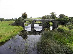
Finn Bridge is a border crossing between the Republic and the North. [3] It was used by Gardaí, RUC and also the Irish and British armies during "The Troubles". The bridge was closed to vehicles in the 1970s, when the British Army fixed concrete pillars onto the middle of it. [4] This was intended to prevent the IRA from moving easily between the two areas. The only way across was by walking through the gaps between the pillars. Since the Northern Ireland peace process, the bridge has been reopened to vehicular traffic. [4] The bridge is on one of a small number of road routes used to access Drummully (also known as Coleman's Island or 'the Sixteen Townlands'), a pene-enclave of County Monaghan in the Republic of Ireland which is accessible by road only via County Fermanagh in Northern Ireland. [5]

Related Research Articles

<span class="mw-page-title-main">County Monaghan</span> County in Ireland

County Monaghan is a county in Ireland. It is in the province of Ulster and is part of Border strategic planning area of the Northern and Western Region. It is named after the town of Monaghan. Monaghan County Council is the local authority for the county. The population of the county was 61,386 according to the 2016 census.

<span class="mw-page-title-main">Clones, County Monaghan</span> Town in County Monaghan, Ireland

Clones is a small town in western County Monaghan, Ireland. The area is part of the Border Region, earmarked for economic development by the Irish Government due to its currently below-average economic situation. The town was badly hit economically by the Partition of Ireland in 1921 because of its location on the border with County Fermanagh in Northern Ireland. The creation of the Irish border deprived it of access to a large part of its economic hinterland for many years. The town had a population of 1,680 at the 2016 census.

<span class="mw-page-title-main">Carrickmacross</span> Town in County Monaghan, Ireland

Carrickmacross is a town in County Monaghan, Ireland. The town and environs had a population of 5,032 according to the 2016 census, making it the second-largest town in the county. Carrickmacross is a market town which developed around a castle built by the Earl of Essex in 1630. The town won the European Entente Florale Silver Medal Award in 1998. The local Gaelic football and hurling club is Carrickmacross Emmets. The local soccer team is Carrick Rovers.

<span class="mw-page-title-main">Ballintra</span> Village in County Donegal, Ireland

Ballintra is a village in the parish of Drumholm in the south of County Donegal, Ireland, just off the N15 road between Donegal town and Ballyshannon. Ballintra lies on the northern bank of the Blackwater river. The river rises in the hills that lie inland from the town, and flows through a number of small lakes before spilling over a small waterfall in a gorge behind the village.

<span class="mw-page-title-main">Riverstown</span> Village in County Sligo, Ireland

Riverstown, historically called Ballyederdaowen, is a village in County Sligo, Ireland. Known for its musical tradition it is located at a bridging point of the River Unshin (Arrow), 17.2 km south of Sligo town and 4 km east of the N4 road.

<span class="mw-page-title-main">Stradone, County Cavan</span> Village in County Cavan, Ireland

Stradone is a village located in County Cavan, Ireland. It is situated in the civil parish of Laragh six miles from Cavan, near the N3 road between Cavan and Virginia. Stradone is classified as a 'small village' in the Cavan County Council Development Plan 2014-2020.

<span class="mw-page-title-main">Scotshouse</span> Village in County Monaghan, Ireland

Scotshouse is a small agricultural village in the parish of Currin in County Monaghan, Ireland. It is roughly three miles east of where the counties of Cavan, Fermanagh and Monaghan meet. Scotshouse is about 7 kilometres (4 mi) from Clones, 18 km (11 mi) from Cavan town and 27 km (17 mi) away from Monaghan town.

<span class="mw-page-title-main">Ballyhaise</span> Village in Ulster, Ireland

Ballyhaise is a village in County Cavan, Ireland. It is situated some 7 km (4.3 mi) north-northeast of Cavan Town. It is approximately a 15-minute drive or 11 km via the N54 to the border with County Fermanagh in Northern Ireland. The River Annalee flows near the village.

<span class="mw-page-title-main">Slieve Beagh</span> Mountain on the border of Monaghan (R. Ireland), Fermanagh and Tyrone (N. Ireland)

Slieve Beagh is a mountainous area straddling the border between County Monaghan in the Republic of Ireland and County Fermanagh and County Tyrone in Northern Ireland. A point just east of its summit is the highest point in Monaghan; however the true summit is on the Fermanagh-Tyrone border. The point where the three counties meet, is referred to as the "Three County Hollow".

<span class="mw-page-title-main">Kilcolgan</span> Village in County Galway, Ireland

Kilcolgan, is a village on the mouth of the Kilcolgan River at Dunkellin Bay in County Galway, Ireland. The settlement is at the junction of the N67 and R458 roads, which lies between Gort and Clarinbridge. The village is near the site of the Galway Bay drowning tragedy. Kilcolgan was designated as a census town by the Central Statistics Office for the first time in the 2016 census, at which time it had a population of 141 people.

<span class="mw-page-title-main">Nenagh River</span> Tributary of the Shannon in County Tipperary, Ireland

The Nenagh River rises in the Silvermine Mountains in County Tipperary, Ireland. It flows east of Nenagh and into Lough Derg just north of Dromineer.

Sharavogue is a townland in the historical Barony of Clonlisk, County Offaly, Ireland. It is a rural area located near the junction of the N52 road and the R492 between Roscrea and Birr. The Little Brosna River flows under Sharavogue bridge.

<span class="mw-page-title-main">Figile River</span> River in Ireland

The Figile River is a river in eastern Ireland.

The Yellow River is a river in central Ireland, a tributary of the River Boyne.

<span class="mw-page-title-main">Drummully</span> Electoral district and pene-enclave in County Monaghan, Ireland

Drummully or Drumully is an electoral division (ED) in the west of County Monaghan in Ireland. Known as the Sixteen Townlands to locals and as Coleman's Island or the Clonoony salient to the security forces, it is a pene-enclave almost completely surrounded by County Fermanagh in Northern Ireland. Since the Partition of Ireland in the 1920s, the Monaghan–Fermanagh border has formed part of the international border between the Republic of Ireland and the United Kingdom, leaving Drummully as a practical enclave, connected to the rest of what is now the Republic of Ireland only by an unbridged 110 metres (360 ft) length of the Finn River. The area is accessed via the Clones–Butlersbridge road, numbered N54 in the Republic and A3 in Northern Ireland.

<span class="mw-page-title-main">Drum, County Monaghan</span> Village in County Monaghan, Ulster, Ireland

Drum is a village and townland in the west of County Monaghan in the Republic of Ireland. It is notable for being one of the only Protestant-majority settlements in the Republic of Ireland.

29 Martello towers and battery installations were constructed or partially constructed in the Greater Dublin Area between 1803 and 1808. The towers were intended to act as a deterrent against a foreign invasion by Napoleon and his French Armies as well as being used as general lookout posts. In later years, towers were also used as coast guard stations, lookout stations to prevent smuggling and as other general purpose military installations by various British and Irish defence forces.

<span class="mw-page-title-main">Finn River (County Fermanagh and County Monaghan)</span> Small river in Ulster, Ireland

The Finn River, also known as the River Finn, is a small river that flows through parts of County Fermanagh and parts of County Monaghan in the south of Ulster, the northern province in Ireland. In certain places, the river forms part of the boundary between County Fermanagh, which is part of Northern Ireland, and County Monaghan, which is part of the Republic of Ireland. Two very short stretches of the river, just north of Redhills and at Castle Saunderson, near Belturbet, also form part of the boundary between County Fermanagh and County Cavan. This means that some stretches of the river form part of the border between Northern Ireland and the Republic of Ireland, these short stretches also forming part of the external border of the European Union.

Wattlebridge, sometimes written as Wattle Bridge, is a small hamlet in the south-south-east of County Fermanagh in Northern Ireland. The hamlet is located almost 3½ miles south of the village of Newtownbutler. The hamlet is in a region known unofficially as South Ulster.

References

  1. "Annaghmullin Bridge, Tullyhumphry, County Monaghan". buildingsofireland.ie. National Inventory of Architectural Heritage. Retrieved 21 August 2020.
  2. "Railway bridge, Tullyhumphry, County Monaghan". buildingsofireland.ie. National Inventory of Architectural Heritage. Retrieved 21 August 2020.
  3. "The 310 Miles Breaking Brexit". bloomberg.com. Bloomberg Publishing. 15 March 2019. Retrieved 21 August 2020.
  4. 1 2 "Annaghmullin (Or Finn) Bridge". borderroadmemories.com. Retrieved 21 August 2020.
  5. "Enclave with no way out of the Irish hard border dilemma". thetimes.co.uk. The Times. 5 August 2017. Retrieved 21 August 2020.

Coordinates: 54°06′54″N7°18′56″W / 54.1151°N 7.3155°W / 54.1151; -7.3155